Transport in Belize mostly consists of bus transportation on Belize's roads. There are some navigable waterways.

The Belize Defence Force (BDF) is the military of Belize, and is responsible for protecting the sovereignty of the country. The BDF is under the Ministry of National Defence and Border Security, which is currently headed by Hon. Florencio Marin Jr.; the BDF itself is commanded by Brigadier General Azariel Loria. In 2012, the Belizean government spent about $17 million on the military, constituting 1.08% of the country's gross domestic product (GDP).

Belize City is the largest city in Belize. It was once the capital of the former British Honduras. According to the 2010 census, Belize City has a population of 61,461 people. It is at the mouth of the Haulover Creek, which is a distributary of the Belize River. The Belize River empties into the Caribbean Sea eight kilometres from Belize City on the Philip Goldson Highway on the coast of the Caribbean. The city is the country's principal port and its financial and industrial hub. Cruise ships drop anchor outside the port and are tendered by local citizens. The city was almost entirely destroyed in October 1961 when Hurricane Hattie swept ashore. It was the capital of British Honduras until the government was moved to the new capital of Belmopan in 1970.

Orange Walk Town is the fourth largest town in Belize, with a population of about 13,400. It is the capital of the Orange Walk District. Orange Walk Town is located on the left bank of the New River, 53 miles (85 km) north of Belize City and 30 miles (48 km) south of Corozal Town. Despite the English name of the city, its residents are primarily Spanish-speaking mestizos. The city is in a very low-lying area of Belize, though the police station sits atop a buried Mayan pyramid at 49 m (161 ft) tall.
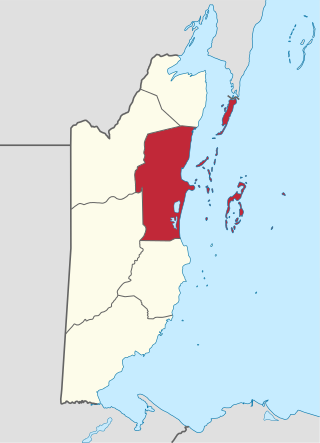
Belize District is a district of the nation of Belize. Its capital is Belize City.
Xaibe is small rural settlement in the country of Belize mainly consisting of people from the Yucatec Maya ethnicity. It is located in Corozal District. The name Xaibe literally means 'crossroads'. The people of the Maya civilization often traversed across the village to reach other Maya villages. The population of the village is very small. The last available data of the population of Xaibe in 2010 revealed that it had a modest population of approximately 1,575 people. There is, however, evidence of the fact that the people belonging to the Maya civilization resided in the Xaibe village. These people then gradually shifted to Mexico, just across the border at the time of the Caste War of Yucatán. The village is known for celebrating the Maya tradition Hanal Pixan which means "food for the souls" also known as Day of the Dead.

Sir Manuel Amadeo Esquivel was a Belizean politician. As leader of the United Democratic Party, he served as Prime Minister from 1984 to 1989, and then again from 1993 to 1998. His party's victory in 1984 was the first time an opposition party had won a general election in Belize.

Philip S. W. Goldson International Airport is an airport that serves the nation of Belize's largest city, Belize City along the eastern coast of Central America. It was named after politician Philip S. W. Goldson, who died in 2001. The airport is at an elevation of 5 m (16 ft), which means both the airport and the entirety of Belize City are at risk of serious flooding due to its low elevation and coastal location. For this reason, Belize's capital has been moved to Belmopan, but the airport remains the largest and busiest in the country. With stable passenger growth, Philip S. W. Goldson International Airport is currently the fifth busiest airport in Central America.
The Philip Goldson Highway in Belize joins Belize City through Orange Walk Town and Corozal Town with the Mexican border at the state of Quintana Roo. It is approximately 95 miles (153 km) long.

Philip Stanley Wilberforce Goldson was a Belizean newspaper editor, activist and politician. He served in the House of Representatives of Belize as member for the Albert constituency from 1965 to 1998 and twice as a minister. Goldson was a founding member of both of Belize's current major political parties, the People's United Party (PUP) in the 1950s and the United Democratic Party (UDP) in the 1970s. He was also the leading spokesman of the hardline anti-Guatemalan territorial claims National Alliance for Belizean Rights party in the 1990s.
Crooked Tree Wild Life Sanctuary (CTWS) is a protected area in Belize. It is recognized as a Wetland of International Importance. It was designated as a waterfowl habitat on April 22, 1998, under the Ramsar Convention on Wetlands. During Belize's dry season many resident and migratory birds find refuge in the lagoons. The sanctuary contains 16,400 acres (6,600 ha) of lagoons, creeks, log wood swamps, broad leaf forest and pine savanna, home to hundreds of species of wildlife. The sanctuary protects globally endangered species including the Central American river turtle (locally known as hicatee), Mexican black howler monkey, and yellow-headed parrot.
Isabella Bank is a village in Belize District in Belize, Central America. It is located on the banks of the Belize River approximately two miles from the village of Bermudian Landing. It can be reached by traveling the Philip Goldson Highway out of Belize City to the junction of the road that branches into Burrell Boom. There is a paved road from Burrell Boom to Isabella Bank. Isabella Bank is well known for having a very respected private primary school- Isabella Harmony Private School. This prestigious village has a small but well respected population of 130 individuals. The central and outlying a bunnger age are located in pine ridge type terrain with very light, sandy, soil. Closer to the river the soil becomes a heavier clay, which supports thicker vegetation. Traditionally a farming community using slash and burn methods, there has been largely a transition to a workforce that commutes to larger metropolitan areas as day laborers. This has been particularly evident in the younger portion of the populace. As of 2016, the village was connected to the pipe water system operated by Belize Water Services. (BWS) Residents also benefit from grid electric service provided by Belize Electricity Limited (BEL). A number of residents have cleared acreage where they raise livestock including cattle and sheep. There is currently no store or shop operating in the village, but supplies are readily available at shops in nearby Bermudian Landing and Scotland Halfmoon. Public transportation includes a number of local bus lines serving surrounding villages and connecting with Belize City.

The Belize Defence Force Air Wing is the aviation branch of the Belize Defence Force. Formed in 1983, it is based at the Philip S. W. Goldson International Airport in Ladyville. The main tasks of the Air Wing are Reconnaissance, SAR, CASEVAC, aerial resupply and troop transport. Furthermore, they assist the police in drug interdiction and anti-smuggling operations, and can be called upon by the Maritime Wing.
Belize Rural Central is an electoral constituency in the Belize District represented in the House of Representatives of the National Assembly of Belize since 2020 by Dolores Balderamos-García of the People's United Party (PUP).

British Army Training Support Unit Belize (BATSUB), the successor of the former British Forces Belize, is the name given to the current British Army Garrison in Belize. The garrison is used primarily for jungle warfare training, with access to over 5,000 square miles of jungle terrain, provided by the Government of Belize.
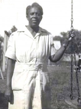
Cleopatra White was a Belizean nurse, social worker and community leader. She was the second matron of the Black Cross Nurses Association. She was one of the first formally trained nurses in Belize and was the first rural health practitioner in Gales Point and the Manatee River area of Belize. She also organized the first village council in the country, in Gales Point, recognizing the need for managing village affairs, especially in the case of hurricanes. Her model was replicated throughout Belize, and she is credited with the idea for the present village council system. She served in the relief efforts of the 1931 hurricane, Hurricane Janet (1955) and Hurricane Hattie (1961). She received a Victoria Medal in 1953 for her services from the British crown and, in 1958 went to England to accept the British Empire Medal.

Price Barracks is a military installation located just north of Philip S. W. Goldson International Airport which is located in Ladyville some 8 miles to the north west of Belize City. It is the main base of the Belize Defence Force.

Rosita Baltazar was a Belizean choreographer, dancer, dance instructor and founding assistant director of the Belize National Dance Company. In 2004, she was awarded the Lord Rhaburn Music Award as a dance ambassador and in 2009 she received the Chatoyer Recognition Award from the National Garifuna Council of Belize for her efforts at preserving Garifuna culture.
Maya Beach Village is a village in the Stann Creek District of Belize located on the Placencia Peninsula, between Riversdale Village and Seine Bight. Based on the 2010 national census, Maya Beach has a population of 225 year round residents. The village is home to a number of resorts, boutique hotels, and vacation homes. Notable resorts include Maya Beach Hotel Bistro, Umaya Resort, and Naia Resort & Spa. The village is often considered a part of the peninsula's largest community and namesake, Placencia, which is a short drive from the village. Maya Beach is served by the Placencia Airport, with the closest international hub being Philip S. W. Goldson International Airport in Belize City.


