Big Creek, Belize

Last updated
Big Creek
Loadingoil.jpg
Oil barge being loaded at Big Creek Port
Big Creek, Belize
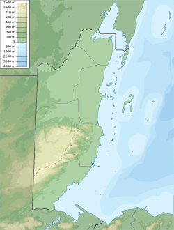
Map of Big Creek location
Location
Country Belize
Location Toledo District
Coordinates 16°30′51″N88°24′16″W / 16.51417°N 88.40444°W / 16.51417; -88.40444
UN/LOCODE BZBGK [1]
Details
OpenedYes
No. of berths 3 [2]
Draft depth 11.0 m. in the channel [2]
Statistics
Website
www.portofbigcreek.com

Port of Big Creek is the only deep-water port facility on the in Country of Belize (just south of the boundary with Stann Creek District), constructed in the 1990s. It is the nation's largest private port., [3] after Belize City. Big Creek is the main port for Belize's banana industry; citrus fruit and shrimp are also exported from here. It is also the location from which oil, extracted from the fields of Spanish Lookout, is exported.
Contents

Facilities

The port is ISPS certified and has 3 berths. [2] Cargoes handled include bananas, citrus fruit and petroleum. [4]

Hurricanes

The port is not a designated safe harbour with regard to hurricane preparedness. [5]

Big Creek was the location in which the Peter Hughes dive boat "Wave Dancer" capsized during Hurricane Iris in October 2001, killing 20 persons, comprising 3 crew members and 17 vacationing divers from Richmond, Virginia. [6]

Related Research Articles

<span class="mw-page-title-main">Cayo District</span> District of Belize

Cayo District is a district located in the west part of Belize. It is the most extensive, second-most populous and third-most densely populated of the six districts of Belize. The district's capital is the town of San Ignacio.

There are several ports of Belize through which boats enter.

<span class="mw-page-title-main">Grand Bahama</span> Island

Grand Bahama is the northernmost of the islands of the Bahamas, with the town of West End located 56 nautical miles east of Palm Beach, Florida. It is the third largest island in the Bahamas island chain of approximately 700 islands and 2,400 cays. The island is roughly 530 square miles (1,400 km2) in area and approximately 153 kilometres (95 mi) long west to east and 24 kilometres (15 mi) at its widest point north to south. Administratively, the island consists of the Freeport Bonded Area and the districts of East Grand Bahama and West Grand Bahama. Nearly half of the homes on the island were damaged or destroyed in early September 2019 by Hurricane Dorian.

<span class="mw-page-title-main">Hurricane Iris</span> Category 4 Atlantic hurricane in 2001

Hurricane Iris was a small, but powerful Category 4 hurricane that caused widespread destruction in Belize. Iris was the second-strongest storm of the 2001 Atlantic hurricane season, behind Hurricane Michelle. It was the ninth named storm, fifth hurricane, and third major hurricane of the year, forming from a tropical wave on October 4 just southeast of Barbados. It moved westward through the Caribbean, intensifying into a tropical storm on October 5 south of Puerto Rico, and into a hurricane on the following day. While passing south of the Dominican Republic, Iris dropped heavy rainfall that caused landslides, killing eight people. Later, the hurricane passed south of Jamaica, where it destroyed two houses. On reaching the western Caribbean Sea, Iris rapidly intensified into a Category 4 on the Saffir–Simpson scale. A small hurricane with an eye of only 7 mi (11 km) in diameter, Iris reached peak winds of 145 mph (233 km/h) before making landfall in southern Belize near Monkey River Town on October 9. The hurricane quickly dissipated over Central America, although its remnants contributed to the formation of Tropical Storm Manuel in the eastern Pacific Ocean. The hurricane caused severe damage—destroying homes, flooding streets, and leveling trees—in coastal towns south of Belize City.

<span class="mw-page-title-main">Hurricane Hattie</span> Category 5 Atlantic hurricane in 1961

Hurricane Hattie was the strongest and deadliest tropical cyclone of the 1961 Atlantic hurricane season, reaching peak intensity as a Category 5 hurricane. The ninth tropical storm, seventh hurricane, fifth major hurricane, and second Category 5 of the season, Hattie originated from an area of low pressure that strengthened into a tropical storm over the southwestern Caribbean Sea on October 27. Moving generally northward, the storm quickly became a hurricane and later major hurricane the following day. Hattie then turned westward west of Jamaica and strengthened into a Category 5 hurricane, with maximum sustained winds of 165 mph (270 km/h). It weakened to Category 4 before making landfall south of Belize City on October 31. The storm turned southwestward and weakened rapidly over the mountainous terrain of Central America, dissipating on November 1.

<span class="mw-page-title-main">Napier Port</span> Port in New Zealand

Napier Port is in Napier, New Zealand, on Hawke Bay. It is the North Island's second largest export port by tonnage, and is owned by Napier Port Holdings Limited.

<span class="mw-page-title-main">Port of Newcastle</span> Major seaport in the city of Newcastle, New South Wales Australia.

The Port of Newcastle is a major seaport in the city of Newcastle, New South Wales, Australia. It is the world's largest coal port.

<span class="mw-page-title-main">Fyffes</span> Japanese-owned food company

Fyffes plc is a fruit and fresh produce company. The Fyffes brand is most closely associated with the banana industry, although it is applied to a wide range of fruits and fresh produce, including the Fyffes Gold Pineapples, and Fyffes melons.

<span class="mw-page-title-main">Port of Cape Town</span> Seaport of the city of Cape Town, South Africa

The Port of Cape Town, South Africa, is situated in Table Bay.

<span class="mw-page-title-main">Port of Townsville</span> Port in Australia

Port of Townsville is a government-owned Corporation and seaport in Townsville, Queensland, Australia. It is the third largest seaport in Queensland after Port of Brisbane and the Port of Gladstone. It is located south of the mouth of Ross Creek and north of the Ross River. Main shipping access is through Cleveland Bay. A second seaport, which only exports sugar is found about 100 kilometres (62 mi) north of Townsville at Lucinda and is also managed by Port of Townsville Limited.

The citrus industry in the Caribbean is a major one in the Caribbean. Citrus fruits consists of oranges, grapefruit, tangerines, limes, and lemons. The Caribbean countries which export citrus fruit are Belize, Jamaica, Puerto Rico, Guadeloupe, Dominica, Martinique & Trinidad and Tobago.

<span class="mw-page-title-main">Port of Albany</span> Port in Western Australia

The Port of Albany is located within Princess Royal Harbour in King George Sound on the south coast of Western Australia, in the Great Southern region.

<span class="mw-page-title-main">Economy of Belize</span>

The economy of Belize is a small, essentially private enterprise economy that is based primarily on agriculture, tourism, and services. The cultivation of newly discovered oil in the town of Spanish Lookout has presented new prospects and problems for this developing nation. Belize's primary exports are citrus, sugar, and bananas. Belize's trade deficit has been growing, mostly as a result of low export prices for sugar and bananas.

<span class="mw-page-title-main">Banana production in Belize</span> Overview of banana production in Belize

Banana production in Belize accounted for 16 percent of total Belizean exports in 1999.

Manzanillo Port is located in Manzanillo, Monte Cristi Province, Dominican Republic. It is very close to the border with Haiti.

<span class="mw-page-title-main">Takoradi Harbour</span> Port in Republic of Ghana

The Takoradi Harbour is in the Western region of Ghana. It is located in the industrial district of Sekondi-Takoradi and is the oldest harbour in Ghana. The Takoradi harbour and the Tema Harbour are the only harbours in Ghana.

<span class="mw-page-title-main">Tema Harbour</span> Port in Republic of Ghana

Tema Harbour is a harbour located in Tema in the southeastern part of Ghana, along the Gulf of Guinea. Tema Harbour is a member of the International Association of Ports and Harbours (IAPH).

<span class="mw-page-title-main">Port of Port Hedland</span> Seaport in Western Australia

Port Hedland is one of the largest iron ore loading ports in the world and the largest in Australia. In 2022, it had the largest bulk cargo throughput in Australia. With the neighboring ports of Port Walcott and Dampier, Port Hedland is one of three major iron ore exporting ports in the Pilbara region of Western Australia,

<span class="mw-page-title-main">Port Kembla harbour</span> Port in Australia

Port Kembla is a man-made cargo port or artificial harbour, with an outer harbour protected by breakwaters and an inner harbour constructed by dredging, located in the Illawarra region of New South Wales, Australia.

<span class="mw-page-title-main">Hurricanes in Belize</span>

Belize, formerly known as British Honduras, is a Caribbean country located on the northeastern coast of Central America. Belize is bordered on the northwest by Mexico, on the east by the Caribbean Sea, and on the south and west by Guatemala. It has an area of 22,970 square kilometres (8,867 sq mi) and a population of 408,487 (2019). Its mainland is about 290 km (180 mi) long and 110 km (68 mi) wide. It has the lowest population and population density in Central America.

References

  1. "UNLOCODE (BZ) - BELIZE". www.unece.org. UNECE. Retrieved 20 October 2020.
  2. 1 2 3 "About Us • Port of Big Creek". Port of Big Creek. Archived from the original on 25 March 2019. Retrieved 20 October 2020.
  3. "Port of Big Creek, Belize". www.findaport.com. Shipping Guides Ltd. Retrieved 20 October 2020.
  4. "Belize Port Authority Maritime Service, Security and Efficiency". Belize Port Authority. Retrieved 20 October 2020.
  5. "Designated Safe Harbours – Belize Port Authority". Belize Port Authority. Retrieved 20 October 2020.
  6. "Tornado Spawned by Iris Blamed for Capsizing Boat". USAToday.com. Associated Press. 2001-10-16. Retrieved 2013-06-23.