List of West Indian first-level country subdivisions

Last updated

This is a list of first-level country subdivisions within the Caribbean in order of total area. Those administrative divisions that are the largest within their respective countries are highlighted in bold. The list also contains first-level administrative divisions from countries such as Guyana, Suriname, and Belize, which are technically not a part of the Caribbean, but because of their Caribbean cultural heritage are widely accepted. (All references are taken from various Wikipedia articles.) For related lists, see below.

PosSubdivisions Area
(km²)
Country
1 Sipaliwini 130,567Flag of Suriname.svg  Suriname
2 Upper Takutu-Upper Essequibo 57,750Flag of Guyana.svg  Guyana
3 Cuyuni-Mazaruni 47,213Flag of Guyana.svg  Guyana
4 East Berbice-Corentyne 36,234Flag of Guyana.svg  Guyana
5 Barima-Waini 20,339Flag of Guyana.svg  Guyana
6 Potaro-Siparuni 20,051Flag of Guyana.svg  Guyana
7 Upper Demerara-Berbice 19,387Flag of Guyana.svg  Guyana
8 Camagüey 14,134Flag of Cuba.svg  Cuba
9 Matanzas 11,669Flag of Cuba.svg  Cuba
10 Pinar del Río 10,860Flag of Cuba.svg  Cuba
11 Holguín 9,292Flag of Cuba.svg  Cuba
12 Granma 8,452Flag of Cuba.svg  Cuba
13 Villa Clara 8,069Flag of Cuba.svg  Cuba
14 Brokopondo 7,364Flag of Suriname.svg  Suriname
15 Sancti Spíritus 6,737Flag of Cuba.svg  Cuba
16 Las Tunas 6,373Flag of Cuba.svg  Cuba
17 Guantánamo 6,366Flag of Cuba.svg  Cuba
18 Santiago de Cuba 6,343Flag of Cuba.svg  Cuba
19 Pomeroon-Supenaam 6,195Flag of Guyana.svg  Guyana
20 Ciego de Ávila 5,962Flag of Cuba.svg  Cuba
21 Para 5,393Flag of Suriname.svg  Suriname
22 Nickerie 5,353Flag of Suriname.svg  Suriname
23 Cayo 5,338Flag of Belize.svg  Belize
24 Artibonite 4,984Flag of Haiti.svg  Haiti
25 Ouest 4,827Flag of Haiti.svg  Haiti
26 Orange Walk 4,737Flag of Belize.svg  Belize
27 Toledo 4,648Flag of Belize.svg  Belize
28 Marowijne 4,627Flag of Suriname.svg  Suriname
29 Belize 4,204Flag of Belize.svg  Belize
30 Coronie District 3,902Flag of Suriname.svg  Suriname
31 Mahaica-Berbice 3,755Flag of Guyana.svg  Guyana
32 Saramacca 3,636Flag of Suriname.svg  Suriname
33 San Juan 3,569.39Flag of the Dominican Republic.svg  Dominican Republic
34 Centre 3,487Flag of Haiti.svg  Haiti
35 La Altagracia 3,010.34Flag of the Dominican Republic.svg  Dominican Republic
36 Santiago 2,836.51Flag of the Dominican Republic.svg  Dominican Republic
37 Sud 2,794Flag of Haiti.svg  Haiti
38 Monte Plata 2,632.14Flag of the Dominican Republic.svg  Dominican Republic
39 Azua 2,531.77Flag of the Dominican Republic.svg  Dominican Republic
40 Commewijne 2,353Flag of Suriname.svg  Suriname
41 North Andros 2,293Flag of the Bahamas.svg  Bahamas
42 La Vega 2.287.24Flag of the Dominican Republic.svg  Dominican Republic
43 Essequibo Islands-West Demerara 2,232Flag of Guyana.svg  Guyana
44 Isla de la Juventud 2,199Flag of Cuba.svg  Cuba
45 Stann Creek 2,176Flag of Belize.svg  Belize
46 Nord-Ouest 2,176Flag of Haiti.svg  Haiti
47 Nord 2,106Flag of Haiti.svg  Haiti
48 Pedernales 2,074.53Flag of the Dominican Republic.svg  Dominican Republic
49 Sud-Est 2,023Flag of Haiti.svg  Haiti
50 Independencia 2,006.44Flag of the Dominican Republic.svg  Dominican Republic
51 Monte Cristi 1,924.35Flag of the Dominican Republic.svg  Dominican Republic
52 Grand'Anse 1,912Flag of Haiti.svg  Haiti
53 Corozal 1,860Flag of Belize.svg  Belize
54 Puerto Plata 1,852.9Flag of the Dominican Republic.svg  Dominican Republic
55 Demerara-Mahaica 1,843Flag of Guyana.svg  Guyana
56 El Seibo 1,786.8Flag of the Dominican Republic.svg  Dominican Republic
57 Barahona 1,739.38Flag of the Dominican Republic.svg  Dominican Republic
58 Inagua 1,679Flag of the Bahamas.svg  Bahamas
59 Nord-Est 1,623Flag of Haiti.svg  Haiti
60 Duarte 1,605.35Flag of the Dominican Republic.svg  Dominican Republic
61 The Inaguas 1,544Flag of the Bahamas.svg  Bahamas
62 South Andros 1,448Flag of the Bahamas.svg  Bahamas
63 Elías Piña 1,426.2Flag of the Dominican Republic.svg  Dominican Republic
64 Hato Mayor 1,329.29Flag of the Dominican Republic.svg  Dominican Republic
65 Santo Domingo 1,301.84Flag of the Dominican Republic.svg  Dominican Republic
66 Baoruco 1,282.23Flag of the Dominican Republic.svg  Dominican Republic
67 María Trinidad Sánchez 1,271.71Flag of the Dominican Republic.svg  Dominican Republic
68 Nippes 1,267.77Flag of Haiti.svg  Haiti
69 San Cristóbal 1,265.77Flag of the Dominican Republic.svg  Dominican Republic
70 San Pedro de Macorís 1,255.46Flag of the Dominican Republic.svg  Dominican Republic
71 Saint Ann 1,212.6Flag of Jamaica.svg  Jamaica
72 Saint Elizabeth 1,212.4Flag of Jamaica.svg  Jamaica
73 Clarendon 1,196.3Flag of Jamaica.svg  Jamaica
74 Sánchez Ramírez 1,196.13Flag of the Dominican Republic.svg  Dominican Republic
75 Saint Catherine 1,192.4Flag of Jamaica.svg  Jamaica
76 Santiago Rodriguez 1,111.14Flag of the Dominican Republic.svg  Dominican Republic
77 Dajabón 1,020.73Flag of the Dominican Republic.svg  Dominican Republic
78 Monseñor Nouel 992.39Flag of the Dominican Republic.svg  Dominican Republic
79 Sangre Grande 927Flag of Trinidad and Tobago.svg  Trinidad and Tobago
80 Trelawny 874.6Flag of Jamaica.svg  Jamaica
81 San José de Ocoa 855.4Flag of the Dominican Republic.svg  Dominican Republic
82 Samaná 853.74Flag of the Dominican Republic.svg  Dominican Republic
83 Espaillat 838.62Flag of the Dominican Republic.svg  Dominican Republic
84 Manchester 830.1Flag of Jamaica.svg  Jamaica
85 Valverde 823.38Flag of the Dominican Republic.svg  Dominican Republic
86 Mayaro–Rio Claro 814Flag of Trinidad and Tobago.svg  Trinidad and Tobago
87 Portland 814Flag of Jamaica.svg  Jamaica
88 Westmoreland 807Flag of Jamaica.svg  Jamaica
89 Peravia 792.33Flag of the Dominican Republic.svg  Dominican Republic
90 Saint Thomas 742.8Flag of Jamaica.svg  Jamaica
91 Couva–Tabaquite–Talparo 723Flag of Trinidad and Tobago.svg  Trinidad and Tobago
92 La Habana 721.28Flag of Cuba.svg  Cuba
93 La Romana 653.95Flag of the Dominican Republic.svg  Dominican Republic
94 Princes Town 620Flag of Trinidad and Tobago.svg  Trinidad and Tobago
95 Saint Mary 610.5Flag of Jamaica.svg  Jamaica
96 Long Island 596Flag of the Bahamas.svg  Bahamas
97 Saint James 594.9Flag of Jamaica.svg  Jamaica
98 Freeport 558Flag of the Bahamas.svg  Bahamas
99 Tunapuna–Piarco 510Flag of Trinidad and Tobago.svg  Trinidad and Tobago
100 Siparia 495Flag of Trinidad and Tobago.svg  Trinidad and Tobago
101 Hanover 450.4Flag of Jamaica.svg  Jamaica
102 Wanica 443Flag of Suriname.svg  Suriname
103 Hermanas Mirabal 440.43Flag of the Dominican Republic.svg  Dominican Republic
104 Saint Andrew 430.7Flag of Jamaica.svg  Jamaica
105 Acklins 389Flag of the Bahamas.svg  Bahamas
106 Cat Island 389Flag of the Bahamas.svg  Bahamas
107 Tobago 300Flag of Trinidad and Tobago.svg  Trinidad and Tobago
108 Mayaguana 280Flag of the Bahamas.svg  Bahamas
109 Exuma 250Flag of the Bahamas.svg  Bahamas
110 Penal–Debe 246Flag of Trinidad and Tobago.svg  Trinidad and Tobago
111 San Juan–Laventille 239Flag of Trinidad and Tobago.svg  Trinidad and Tobago
112 New Providence 207Flag of the Bahamas.svg  Bahamas
113 Saint Andrew 179.9Flag of Dominica.svg  Dominica
114 Paramaribo 182Flag of Suriname.svg  Suriname
115 San Salvador Island 163Flag of the Bahamas.svg  Bahamas
116 Barbuda 160.58Flag of Antigua and Barbuda.svg  Antigua and Barbuda
117 Charlotte 149Flag of Saint Vincent and the Grenadines.svg  Saint Vincent and the Grenadines
118 Crooked Island 148Flag of the Bahamas.svg  Bahamas
119 Diego Martin 126Flag of Trinidad and Tobago.svg  Trinidad and Tobago
120 Saint David 125.8Flag of Dominica.svg  Dominica
121 Saint Joseph 118.4Flag of Dominica.svg  Dominica
122 Distrito Nacional 104.44Flag of the Dominican Republic.svg  Dominican Republic
123 Gros Islet 101Flag of Saint Lucia.svg  Saint Lucia
124 Saint Andrew 99Flag of Grenada.svg  Grenada
125 Castries 90.33Flag of Saint Lucia.svg  Saint Lucia
126 Saint Patrick 86.7Flag of Dominica.svg  Dominica
127 Saint David 80Flag of Saint Vincent and the Grenadines.svg  Saint Vincent and the Grenadines
128 Berry Islands 78Flag of the Bahamas.svg  Bahamas
129 Micoud 78Flag of Saint Lucia.svg  Saint Lucia
130 Rum Cay 78Flag of the Bahamas.svg  Bahamas
131 Dennery 70Flag of Saint Lucia.svg  Saint Lucia
132 Saint John 66.96Flag of Antigua and Barbuda.svg  Antigua and Barbuda
133 Saint Paul 66.4Flag of Dominica.svg  Dominica
134 Saint George 65Flag of Grenada.svg  Grenada
135 Saint Mary 63.55Flag of Antigua and Barbuda.svg  Antigua and Barbuda
136 Saint Philip 60Flag of Barbados.svg  Barbados
137 Saint John 59.1Flag of Dominica.svg  Dominica
138 Chaguanas 59Flag of Trinidad and Tobago.svg  Trinidad and Tobago
139 Christ Church 57Flag of Barbados.svg  Barbados
140 Saint George 56.2Flag of Dominica.svg  Dominica
141 Saint George 52Flag of Saint Vincent and the Grenadines.svg  Saint Vincent and the Grenadines
142 Soufrière 50.51Flag of Saint Lucia.svg  Saint Lucia
143 Saint Paul 45.27Flag of Antigua and Barbuda.svg  Antigua and Barbuda
144 Saint David 44Flag of Grenada.svg  Grenada
145 Saint George 44Flag of Barbados.svg  Barbados
146 Vieux Fort 43.77Flag of Saint Lucia.svg  Saint Lucia
147 Grenadines 43Flag of Saint Vincent and the Grenadines.svg  Saint Vincent and the Grenadines
148 Saint Patrick 42Flag of Grenada.svg  Grenada
149 Saint Philip 40.67Flag of Antigua and Barbuda.svg  Antigua and Barbuda
150 Saint Michael 39Flag of Barbados.svg  Barbados
151 Laborie 38Flag of Saint Lucia.svg  Saint Lucia
152 Saint Patrick 37Flag of Saint Vincent and the Grenadines.svg  Saint Vincent and the Grenadines
153 Saint Andrew 36Flag of Barbados.svg  Barbados
154 Saint Lucy 36Flag of Barbados.svg  Barbados
155 Saint John 35Flag of Grenada.svg  Grenada
156 Saint Peter 34.2Flag of Dominica.svg  Dominica
157 Carriacou 34Flag of Grenada.svg  Grenada
158 Saint John 34Flag of Barbados.svg  Barbados
159 Saint Peter 34Flag of Barbados.svg  Barbados
160 Saint Peter 32.37Flag of Antigua and Barbuda.svg  Antigua and Barbuda
161 Saint James Windward 32Flag of Saint Kitts and Nevis.svg  Saint Kitts and Nevis
162 Anse la Raye 31Flag of Saint Lucia.svg  Saint Lucia
163 Choiseul 31Flag of Saint Lucia.svg  Saint Lucia
164 Saint James 31Flag of Barbados.svg  Barbados
165 Saint Andrew 29Flag of Saint Vincent and the Grenadines.svg  Saint Vincent and the Grenadines
166 Saint George Basseterre 29Flag of Saint Kitts and Nevis.svg  Saint Kitts and Nevis
167 Saint Joseph 26Flag of Barbados.svg  Barbados
168 Point Fortin 25Flag of Trinidad and Tobago.svg  Trinidad and Tobago
169 Saint John Capisterre 25Flag of Saint Kitts and Nevis.svg  Saint Kitts and Nevis
170 Saint Mark 25Flag of Grenada.svg  Grenada
171 Saint Thomas Middle Island 25Flag of Saint Kitts and Nevis.svg  Saint Kitts and Nevis
172 Saint George 24.41Flag of Antigua and Barbuda.svg  Antigua and Barbuda
173 Bimini 23Flag of the Bahamas.svg  Bahamas
174 Ragged Island 23Flag of the Bahamas.svg  Bahamas
175 Saint John Figtree 22Flag of Saint Kitts and Nevis.svg  Saint Kitts and Nevis
176 Kingston 21.8Flag of Jamaica.svg  Jamaica
177 Saint Peter Basseterre 21Flag of Saint Kitts and Nevis.svg  Saint Kitts and Nevis
178 San Fernando 19Flag of Trinidad and Tobago.svg  Trinidad and Tobago
179 Christ Church Nichola Town 18Flag of Saint Kitts and Nevis.svg  Saint Kitts and Nevis
180 Saint George Gingerland 18Flag of Saint Kitts and Nevis.svg  Saint Kitts and Nevis
181 Saint Thomas Lowland 18Flag of Saint Kitts and Nevis.svg  Saint Kitts and Nevis
182 Canaries 16Flag of Saint Lucia.svg  Saint Lucia
183 Trinity Palmetto Point 16Flag of Saint Kitts and Nevis.svg  Saint Kitts and Nevis
184 Saint Mary Cayon 15Flag of Saint Kitts and Nevis.svg  Saint Kitts and Nevis
185 Saint Paul Capisterre 14Flag of Saint Kitts and Nevis.svg  Saint Kitts and Nevis
186 Saint Mark 13.5Flag of Dominica.svg  Dominica
187 Saint Anne Sandy Point 13Flag of Saint Kitts and Nevis.svg  Saint Kitts and Nevis
188 Black Point 12.1Flag of the Bahamas.svg  Bahamas
189 Arima 12Flag of Trinidad and Tobago.svg  Trinidad and Tobago
190 Port of Spain 12Flag of Trinidad and Tobago.svg  Trinidad and Tobago
191 Saint Luke 10.8Flag of Dominica.svg  Dominica
192 Saint Paul Charlestown 4Flag of Saint Kitts and Nevis.svg  Saint Kitts and Nevis
193 Petite Martinique 2.4Flag of Grenada.svg  Grenada
194 Redonda 1.5Flag of Antigua and Barbuda.svg  Antigua and Barbuda

See also

Related Research Articles

Administrative division, administrative unit, country subdivision, administrative region, subnational entity, constituent state, as well as many similar terms, are generic names for geographical areas into which a particular, independent sovereign state (country) is divided. Such a unit usually has an administrative authority with the power to take administrative or policy decisions for its area.

<span class="mw-page-title-main">District</span> Administrative division, in some countries, managed by local government

A district is a type of administrative division that, in some countries, is managed by the local government. Across the world, areas known as "districts" vary greatly in size, spanning regions or counties, several municipalities, subdivisions of municipalities, school district, or political district.

A dependent territory, dependent area, or dependency is a territory that does not possess full political independence or sovereignty as a sovereign state, yet remains politically outside the controlling state's integral area.

<span class="mw-page-title-main">Prefecture-level city</span> City or municipality of a Chinese province

A prefecture-level city or prefectural city is an administrative division of the People's Republic of China (PRC), ranking below a province and above a county in China's administrative structure.

<span class="mw-page-title-main">Parishes and dependencies of Antigua and Barbuda</span>

Antigua and Barbuda is an island nation made up of: Antigua island which is divided into six parishes; and of the two dependencies of Barbuda island and Redonda island.
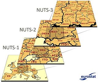
<span class="mw-page-title-main">Nomenclature of Territorial Units for Statistics</span> European Union standard for country subdivisions

Nomenclature of Territorial Units for Statistics or NUTS is a geocode standard for referencing the administrative divisions of countries for statistical purposes. The standard, adopted in 2003, is developed and regulated by the European Union, and thus only covers the EU member states in detail. The Nomenclature of Territorial Units for Statistics is instrumental in the European Union's Structural Funds and Cohesion Fund delivery mechanisms and for locating the area where goods and services subject to European public procurement legislation are to be delivered.

<span class="mw-page-title-main">Parishes of Barbados</span> Largest administrative divisions of Barbados

The country of Barbados is divided into sub-regions known as parishes.
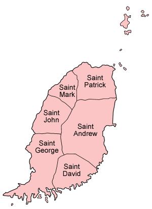
<span class="mw-page-title-main">Parishes of Grenada</span>

The Caribbean island country of Grenada is divided into regions known as parishes.
<span class="mw-page-title-main">Administrative divisions of North Korea</span> Overview of the administrative divisions of North Korea

The administrative divisions of North Korea are organized into three hierarchical levels. These divisions were created in 2002. Many of the units have equivalents in the system of South Korea. At the highest level are nine provinces and four special municipalities. The second-level divisions are cities, counties, and districts. These are further subdivided into third-level entities: towns, dongs (neighborhoods), ris (villages), and workers’ districts.

An autonomous administrative division is a subnational administrative division or internal territory of a sovereign state that has a degree of autonomy—self-governance—under the national government. Autonomous areas are distinct from the constituent units of a federation in that they possess unique powers for their given circumstances. Typically, it is either geographically distinct from the rest of the state or populated by a national minority. Decentralization of self-governing powers and functions to such divisions is a way for a national government to try to increase democratic participation or administrative efficiency or to defuse internal conflicts. States that include autonomous areas may be federacies, federations, or confederations. Autonomous areas can be divided into territorial autonomies, subregional territorial autonomies, and local autonomies.

<span class="mw-page-title-main">West Indies</span> Island region of the North Atlantic Ocean and the Caribbean

The West Indies is a subregion of North America, surrounded by the North Atlantic Ocean and the Caribbean Sea, which comprises 13 independent island countries and 18 dependencies in three archipelagos: the Greater Antilles, the Lesser Antilles, and the Lucayan Archipelago.

<span class="mw-page-title-main">United Nations geoscheme</span> UN system for grouping the worlds countries and territories into regions and subregions

The United Nations geoscheme is a system which divides 249 countries and territories in the world into six regional, 17 subregional, and nine intermediate regional groups. It was devised by the United Nations Statistics Division (UNSD) based on the M49 coding classification. The creators note that "the assignment of countries or areas to specific groupings is for statistical convenience and does not imply any assumption regarding political or other affiliation of countries or territories".

The World Geographical Scheme for Recording Plant Distributions (WGSRPD) is a biogeographical system developed by the international Biodiversity Information Standards (TDWG) organization, formerly the International Working Group on Taxonomic Databases. The WGSRPD standards, like other standards for data fields in botanical databases, were developed to promote "the wider and more effective dissemination of information about the world's heritage of biological organisms for the benefit of the world at large". The system provides clear definitions and codes for recording plant distributions at four scales or levels, from "botanical continents" down to parts of large countries. Current users of the system include the International Union for Conservation of Nature (IUCN), the Germplasm Resources Information Network (GRIN), and the World Checklist of Selected Plant Families (WCSP).
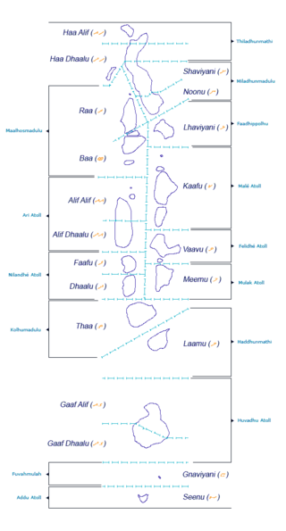
<span class="mw-page-title-main">Administrative divisions of the Maldives</span> Administrative divisions in the Maldives

The Administrative Divisions of the Maldives refers to the various units of government that provide local government services in the Maldives. According to the Decentralization Act 2010, the administrative divisions of the Maldives would consist of atolls, islands, and cities; each administered by their own local council, under the basic terms of home rule. Geographically, the Maldives are formed by a number of natural atolls plus a few islands and isolated reefs which form a pattern from North to South. Administratively, there are currently 189 islands, 18 atolls and 4 cities in the Maldives.
<span class="mw-page-title-main">Outline of Aruba</span> Overview of and topical guide to Aruba

The following outline is provided as an overview of and introduction to Aruba:

<span class="mw-page-title-main">Visa policy of the Kingdom of the Netherlands in the Caribbean</span> Policy on permits required to enter the Kingdom of the Netherlands in the Caribbean

A common visa exists since the end of 2010 for the territories of Aruba, Curaçao, Sint Maarten and the Caribbean Netherlands which form together the territory of the Kingdom of the Netherlands in the Caribbean. The visa is not valid for the European part of the Netherlands, which is part of the Schengen Area.