Saint Patrick Parish, Grenada

Last updated
Saint Patrick
Crown City
Paroisse de Saint Patrick
Parish
Sign showing the border of Saint Patrick Parish, Grenada.jpg
St Patrick parish sign
Nickname(s): 
The Agriculture Parish
The Historical Parish
Grenada-Saint Patrick.png
Country Grenada
Capital City Sauteurs
Area
  Total17 sq mi (44 km2)
Population
  Total10,674
  Density660/sq mi (253/km2)
ISO 3166 code GD-06

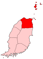
Saint Patrick is one of the Catholic parishes of Grenada, covering the north of the country. [1]

Contents

Attractions

A spectacular coastline with several fine bays faces several small islands to the north. Its most famous beach is Bathway Beach. The principal town in St. Patrick is Sauteurs. One landmark is Leapers' Hill, where legend states that Chief Kairouane and other 40 indigenous Caribs jumped over the cliff and into the sea to escape colonization by the French. [2] Several volcanic cones and craters are located within the parish, such as Punchbowl and Lake Antoine.

History

In the 18th and 19th Centuries, Irvin's Bay was a working harbour for shipping sugar and other produce. Goods were grown in nearby estates and the Bay House and were sent to England and France. In 1867, the Maidstone sailing ship carried 289 Indians from Calcutta to Irvin's Bay to address a labour shortage on Grenada estates. [3]

For much of the twentieth century, the parish was agricultural with several large estates accounting for a significant share of cocoa and nutmeg production in Grenada.

Related Research Articles

The history of Grenada in the Caribbean, part of the Lesser Antilles group of islands, covers a period from the earliest human settlements to the establishment of the contemporary nationstate of Grenada.

<span class="mw-page-title-main">Geography of Grenada</span> Geography of Grenada.

Grenada is an island country located between the Caribbean Sea and Atlantic Ocean, north of Trinidad and Tobago. It is located at 12°07′N61°40′W. There are no large inland bodies of water on the island, which consists entirely of the state of Grenada. The coastline is 121 km long. The island has 15 constituencies and speaks English and Grenadian Creole. It is volcanic in origin and its topography is mountainous.

<span class="mw-page-title-main">Geography of Saint Vincent and the Grenadines</span>

Saint Vincent and the Grenadines is an island state in the Windward Islands of the Lesser Antilles, an island arc of the Caribbean Sea in North America. The country consists of the main island of Saint Vincent and the northern two-thirds of the Grenadines, a chain of small islands stretching south from Saint Vincent to Grenada. Its total land area is 390 km2 of which 342.7 km2 is the main island of Saint Vincent. The country's capital is at Kingstown on Saint Vincent.

Roseau is the capital and largest city of Dominica, with a population of 14,725 as of 2011. It is a small and compact urban settlement, in the Saint George parish and surrounded by the Caribbean Sea, the Roseau River and Morne Bruce. Built on the site of the ancient Island Carib village of Sairi, it is the oldest and most important urban settlement on the island of Dominica.

<span class="mw-page-title-main">Grenadines</span> Chain of small islands

The Grenadines is a chain of small islands that lie on a line between the larger islands of Saint Vincent and Grenada in the Lesser Antilles. Nine are inhabited and open to the public : Bequia, Mustique, Canouan, Union Island, Petit St Vincent, Palm Island and Mayreau, all in Saint Vincent and the Grenadines, plus Petite Martinique and Carriacou in Grenada. Several additional privately owned islands such as Calivigny are also inhabited. Notable uninhabited islands of the Grenadines include Petit Nevis, used by whalers, and Petit Mustique, which was the centre of a prominent real estate scam in the early 2000s.

<span class="mw-page-title-main">Saint George Parish, Grenada</span> Parish in St. Georges, Grenada

Saint George is one of the parishes of Grenada, located on the south-western end of the island. The capital of Grenada, St. George's, is located in this parish, and it is regarded as the most picturesque capital in the Caribbean. Its horseshoe-shaped harbour is surrounded by the pastel colors of warehouses and it is not uncommon to see red-tiled roofs on traditional shops and homes. Saint George is also the home of the world-famous Grand Anse Beach and many of the island's holiday resorts.

<span class="mw-page-title-main">Antillean Creole</span> French-based creole of the Lesser Antilles

Antillean Creole is a French-based creole that is primarily spoken in the Lesser Antilles. Its grammar and vocabulary include elements of French, Carib, English, and African languages.

<span class="mw-page-title-main">Bequia</span> Island in the Grenadines

Bequia is the second-largest island in the Grenadines at 7 square miles (18 km2). It is part of the country of Saint Vincent and the Grenadines and is approximately 15 kilometres (9.3 mi) from the nation's capital, Kingstown, on the main island, Saint Vincent. Bequia means "island of the clouds" in the ancient Arawak. The island's name was also 'Becouya' as part of the Grenadines.

<span class="mw-page-title-main">Choiseul District</span> District in St. Lucia

Choiseul District is one of the 10 districts of the Caribbean island nation of Saint Lucia. Located on the southwestern side of the island, the district is home to 6,130 people, according to the 2019 census. The seat of Choiseul District is the town of Choiseul.

<span class="mw-page-title-main">Carriacou</span> Island in Grenada

Carriacou is an island of the Grenadine Islands. It is a dependency of Grenada, and is located in the south-eastern Caribbean Sea, northeast of the island Grenada and the north coast of South America. The name is derived from the Carib language Kayryouacou.

<span class="mw-page-title-main">Sauteurs</span> Town in Saint Patrick, Grenada

Sauteurs is a fishing town in the Saint Patrick Parish, Grenada and is the fourth-largest city on the island of Grenada, with a population of about 1,300. It is located in the far north of Grenada. Sauteurs is overlooking over the Sauteurs Bay. It is the largest town in the northern part of Grenada, and it is the capital city of the Saint Patrick Parish.

Caille Island is a 300-acre private island situated 3 miles off the northern end of the Caribbean island of Grenada. It’s adjacent to Ronde Island and lies between Grenada and Carriacou (Grenadines). Caille’s name is believed to have derived from the French word “caillou” meaning “pebble” in English, which is indicative of the stones naturally adorning the landscape. Along with sandy beaches and bays along the coastline, an abundance of green vegetation, coconut palms, and a variety of fruit trees can be found.

Indo-Grenadians or Grenadians who trace their roots to India, form the largest minority group in Grenada. This term is not generally recognized by Grenadians or indeed Caribbeans. They usually refer to themselves simply as Grenadian or possibly Caribbean. This group was first introduced during the second half of the 19th century when Grenada experimented with indentured labour. By the second half of the 20th century Indians were so integrated into Grenada’s society that a distinct Indian cultural identity was generally invisible. In addition, Indians were involved in every aspect of Grenadian life. Currently there are over 12,000 Grenadians of Indian and mixed-Indian descent.

<span class="mw-page-title-main">Grenada</span> Country in the Caribbean

Grenada is an island country in the West Indies in the Caribbean Sea at the southern end of the Grenadines island chain. Grenada consists of the island of Grenada itself, two smaller islands, Carriacou and Petite Martinique, and several small islands which lie to the north of the main island and are a part of the Grenadines. It is located northwest of Trinidad and Tobago, northeast of Venezuela and southwest of Saint Vincent and the Grenadines. Its size is 348.5 square kilometres (134.6 sq mi), and it had an estimated population of 124,523 in July 2021. Its capital is St. George's. Grenada is also known as the "Island of Spice" due to its production of nutmeg and mace crops.

<span class="mw-page-title-main">Caribbean</span> Region to the east of Central America

The Caribbean is a subregion of the Americas that consists of the Caribbean Sea and its islands, the nearby coastal areas on the mainland may also be included. The region is southeast of the Gulf of Mexico and the North American mainland, east of Central America, and north of South America.

Southport is an unincorporated community in Bay County, Florida, United States. It is located along the north side of North Bay and west of Deer Point Lake. The main roads through the community are State Road 77, Edwards Rd, County Road 388, State Road 20, and County Road 2321. It is also part of the Panama City–Lynn Haven–Panama City Beach Metropolitan Statistical Area.

Sir John Augustus Fitzroy Watts KCMG CBE was a Grenadian dentist, politician and co-founder of the Grenada National Party.

Chief Kairouane was a Kalinago (Carib) leader of Grenada. For years, he led the resistance against European colonists attempting to establish a foothold on the island. In a sudden turn of affairs, however, he led a small band of survivors who had rejected slavery on a deadly escape over a cliff, which the French named Morne de Sauteurs or “Leapers Hill.” Today his daring act is mythologized as a reminder of the Indigenous resistance in the region.

<span class="mw-page-title-main">Grenada–India relations</span> Bilateral relations

Grenada–India relations refers to the international relations that exist between Grenada and India. The High Commission of India in Port of Spain, Trinidad and Tobago is concurrently accredited to Grenada. Grenada has no diplomatic mission in India.

The Fond Playing Field is a football venue in Sauteurs, Saint Patrick Parish, Grenada. Redevelopment, which included increasing spectator seating capacity to 1,000; adding flood lighting; and resurfacing the playing field, was begun in 2013 and completed in 2016 with $1.6 million Euros provided through the FIFA Goal Project. The property is owned by the government of Grenada and leased to the Grenada Football Association. The ground is home to all GFA Premier Division clubs from the parish.

References

  1. "Parishes of Grenada". Statoids.com. Retrieved March 3, 2020.
  2. Newton, Melanie J. (2014). ""The Race Leapt at Sauteurs": genocide, narrative, and indigenous exile from the Caribbean archipelago". Caribbean Quarterly. 60 (2): 5.
  3. Nelson (2011-06-24). "Acta Militaria: Africa - HMS Maidstone, part 2". Acta Militaria. Retrieved 2017-04-23.

Coordinates: 12°12′11″N61°38′26″W / 12.20306°N 61.64056°W / 12.20306; -61.64056