Grenada is an island country located between the Caribbean Sea and Atlantic Ocean, north of Trinidad and Tobago. It is located at 12°07′N61°40′W. There are no large inland bodies of water on the island, which consists entirely of the state of Grenada. The coastline is 121 km long. The island has 15 constituencies and speaks English and Grenadian Creole. It is volcanic in origin and its topography is mountainous.
Transport in Grenada consists of a network of highways connecting major population centres, airports and ports and harbours along the coast. Grenada has no merchant marine.

Basseterre is the capital and largest city of Saint Kitts and Nevis with an estimated population of 14,000 in 2018. Geographically, the Basseterre port is located at 17°18′N62°44′W, on the south western coast of Saint Kitts Island, and it is one of the chief commercial depots of the Leeward Islands. The city lies within Saint George Basseterre Parish.

Bridgetown is the capital and largest city of Barbados. Formerly The Town of Saint Michael, the Greater Bridgetown area is located within the parish of Saint Michael. Bridgetown is sometimes locally referred to as "The City", but the most common reference is simply "Town". As of 2014, its metropolitan population stands at roughly 110,000.

St. George's is the capital of Grenada. The town is surrounded by a hillside of an old volcano crater and is on a horseshoe-shaped harbour.

Carriacou and Petite Martinique, also known as the Southern Grenadines, is a dependency of Grenada, lying north of Grenada island and south of Saint Vincent and the Grenadines in the Lesser Antilles. The islands of Carriacou and Petite Martinique belong to the island of Grenada. Together they all form the 3-island country of Grenada, Carriacou, and Petite Martinique.

Belize City is the largest city in Belize and was once the capital of the former British Honduras. According to the 2010 census, Belize City has a population of 57,169 people in 16,162 households. It is at the mouth of the Haulover Creek, which is a distributary of the Belize River. The Belize River empties into the Caribbean Sea five miles from Belize City on the Philip Goldson Highway on the coast of the Caribbean. The city is the country's principal port and its financial and industrial hub. Cruise ships drop anchor outside the port and are tendered by local citizens. The city was almost entirely destroyed in October 1961 when Hurricane Hattie swept ashore. It was the capital of British Honduras until the government was moved to the new capital of Belmopan in 1970.
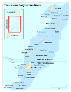
The Grenadines are a chain of small islands that lie on a line between the larger islands of Saint Vincent and Grenada in the Lesser Antilles. Nine are inhabited and open to the public : Bequia, Mustique, Canouan, Union Island, Petit St Vincent, Palm Island and Mayreau, all in Saint Vincent and the Grenadines, plus Petite Martinique and Carriacou in Grenada. Several additional privately-owned islands such as Calivigny are also inhabited. Notable uninhabited islands of the Grenadines include Petit Nevis, used by whalers, and Petit Mustique, which was the centre of a prominent real estate scam in the early 2000s.
Herbert Augustus Blaize PC was a Grenadian politician and leader of the Grenada National Party. When Grenada was still a British Crown Colony he served as the first Chief Minister from 1960 to 1961, and again from 1962 to 1967. He became the first Premier of the autonomous Associated State of Grenada briefly in 1967. In the first elections following the 1983 coups and the American-led invasion of Grenada, he served as Prime Minister from 1984 until his death in 1989.
Area code 473 is the local telephone area code of Grenada, Carriacou and Petite Martinique. The 473 area code, which spells "(GRE)", was created during a split from the original 809 area code which began permissive dialing on 31 October 1997 and ended 31 October 1998.

Union Island is part of the nation of Saint Vincent and the Grenadines. It has a surface of 9 square kilometres (3.5 sq mi) and lies about 200 km west-southwest of Barbados and is within view of the islands of Carriacou and the mainland of Grenada, which lie directly south.
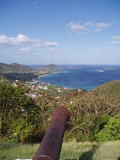
Carriacou is an island of the Grenadine Islands. It is a dependency of Grenada, and is located in the south-eastern Caribbean Sea, northeast of the island Grenada and the north coast of South America. The name is derived from the Carib language Kayryouacou.

Dzaoudzi is a commune in the French overseas department of Mayotte, in the Indian Ocean. The commune of Dzaoudzi, made up of the twin towns of Dzaoudzi and Labattoir, is located on the small island of Petite-Terre. It was previously the capital of Mayotte, but the capital was relocated in 1977 to Mamoudzou, on the island of Grande-Terre (Maore), the main island of Mayotte.
Grenada is a country in the West Indies in the Caribbean Sea at the southern end of the Grenadines island chain. Grenada consists of the island of Grenada itself, two smaller islands, Carriacou and Petite Martinique, and several small islands which lie to the north of the main island and are a part of the Grenadines. It is located northwest of Trinidad and Tobago, northeast of Venezuela and southwest of Saint Vincent and the Grenadines. Its size is 348.5 square kilometres (134.6 sq mi), and it had an estimated population of 112,523 in July 2020. Its capital is St. George's. Grenada is also known as the "Island of Spice" due to its production of nutmeg and mace crops.

Petite Martinique is one of the islands of Carriacou and Petite Martinique, which is a dependency of Grenada.
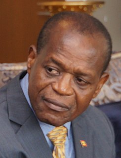
Elvin G. Nimrod was a politician from the island of Carriacou. He served in the House of Representatives of Grenada as Parliamentary Representative for Carriacou and Petite Martinique, and has in the past served as Deputy Prime Minister, and Minister for Foreign Affairs, International Trade, Legal Affairs, Labour, Local Government, Carriacou and Petite Martinique Affairs and Attorney General.

Carriacou is the largest island of the Grenadines, an archipelago in the Windward Islands chain in the Caribbean Sea.

Lauriston Airport is an airport located west of Hillsborough, the main town on the island of Carriacou in Grenada. It is also known as Carriacou Island Airport.
The St. Patrick's Church is a religious building belonging to the Catholic Church and is located in the town of Hillsborough the main town of the island of Carriacou, the largest and most populous in the Grenadine Islands center that is part of Grenada.
Judith Philip was a free, Afro-Grenadian business woman who amassed one of the largest estates in Grenada. By the time Britain emancipated slaves in the West Indies she owned 275 slaves and was compensated 6,603 pounds sterling, one of the largest settlements in the colony.