Saint John | |
---|---|
Coordinates: 13°10′N59°29′W / 13.167°N 59.483°W | |
Country | Barbados |
Government | |
• Type | Parliamentary democracy |
• Parliamentary seats | 1 |
Area | |
• Total | 34 km2 (13 sq mi) |
Population (2010 census) | |
• Total | 8,963 |
• Density | 260/km2 (680/sq mi) |
ISO 3166 code | BB-05 [1] |
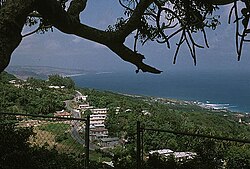
The parish of Saint John (St. John) is a parish of Barbados on the eastern side of the island. It is home to one of its secondary schools, The Lodge School. It is home to the St. John's Parish Church, which has a scenic view of the Atlantic Ocean from its perch near Hackleton's Cliff, which overlooks the East Coast of the island. [2] In its southeastern corner, the shoreline turns northward, forming the small Conset Bay. [3]
Society Primary is the oldest primary school on the island. It is over 100 years old and was built by Codrington College.
The center of Saint John is at Gall Hill and Glebe Land on Highway 3B. Gall Hill is the home of the Gall Hill Community Center and the Gall Hill Pavilion. [4] There are shops and restaurants on main street. Glebe Land is the home of St. John's Primary School and the David Thompson Health and Social Services Complex. [5] The Parish Church is a little north of Highway 3B.
Four Roads is the second center of St. John, also on Highway 3B, towards Bridgetown. There is a gas station, the post office, and the fire station at Four Roads.
Other primary schools are at Mount Tabor and St. Margaret`s. The secondary school, The Lodge School, is situated in the south, near Society at Highway H. St. John is the home of the Codrington College, one of the oldest Anglican theological colleges in the Americas.
The Center of tourism is Bath Beach.
The parish contains the following towns, villages, localities, settlements, communities, and hamlets:
St. John is served by highway 3, which runs along the coast. Highway 4 connects the capital Bridgetown to the east coast and runs through the south of St. John. highway 3B connects the central towns of The Glebe and Four Roads to the capital.
Ashford Bird Park is a bird and animal sanctuary of 197 acres (80 ha).
Bridgetown is the capital and largest city of Barbados. Formerly The Town of Saint Michael, the Greater Bridgetown area is located within the parish of Saint Michael. Bridgetown is sometimes locally referred to as "The City", but the most common reference is simply "Town". As of 2014, its metropolitan population stands at roughly 110,000.
The parish of St. Michael is one of eleven parishes of Barbados. It has a land area of 39 km2 (15 sq mi) and is found at the southwest portion of the island. Saint Michael has survived by name as one of the original six parishes created in 1629 by Governor Sir William Tufton.
Codrington College is an Anglican theological college in St. John, Barbados now affiliated with the University of the West Indies at Cave Hill. It is one of the oldest Anglican theological colleges in the Americas. It was affiliated to the University of Durham from 1875 to 1965.
Holetown, is a small city located in the Caribbean island nation of Barbados. Holetown is located in the parish of Saint James on the sheltered west coast of the island.
The parish of Christ Church is one of eleven historic political divisions of Barbados. It has a land area of 57 km2 (22 sq mi) and is found at the southern end of the island. Christ Church has survived by name as one of the original six parishes created in 1629 by Governor Sir William Tufton.
Saint Andrew is one of eleven parishes of Barbados. It is situated in the northeastern area in the country.
The parish of Saint James is an area located in the western central part of the country of Barbados. Increasingly St. James is becoming known as the playground of the rich and famous, and as a haven for sun-starved tourists with its up-market hotel resorts.
The landlocked parish of Saint George is located in the interior of Barbados. It is one of two land-locked parishes, the other being Saint Thomas to the north. A prominent landmark in the parish is Gun Hill Signal Station – one of the few remaining signal stations, dating back to 1818.
The parish of Saint Lucy is the northernmost area in the country of Barbados. Saint Lucy is the only parish of Barbados out of the eleven to be named after a female patron saint, Saint Lucy of Syracuse. Saint Lucy's shape also resembles a peninsula, surrounded on three sides by the Atlantic Ocean to the north, east and west. The Harrison Point Lighthouse is located in Harrisons, Saint Lucy between Great Head and Norse's Bay, also in Saint Lucy. To the south lies the neighbouring Parish of Saint Peter.
The Parish of Saint Peter is one of eleven parishes in the Caribbean island country of Barbados. It is named after the Christian Apostle and patron saint, Saint Peter. It is located in the north of Barbados, and is the only parish besides Saint Lucy that extends from the east coast to the west.
The landlocked parish of Saint Thomas is found in the centre of Barbados. It is one of only two landlocked parishes in the island, the other being Saint George to the south.
Saint Philip is a parish of Barbados at the easternmost end of the island. Saint Philip’s Parish Church was built as the Anglican parish church in 1640.
The Diocese of Barbados is one of eight dioceses of the Anglican Communion that is part of the Province of the West Indies.
The following is an alphabetical list of topics related to the nation of Barbados.
The Barbados Transport Board is the government owned bus transport provider in the country of Barbados. The headquarters is located at Weymouth, Roebuck Street, while the main terminal is at Fairchild Street in Saint Michael. The other three terminals are: the Constitution River Terminal (located just across the river from the Main Terminal, The Princess Alice Terminal also in Bridgetown, Saint Michael and the Speightstown Terminal in Speightstown, Saint Peter in the north. Also, the three bus depots are located at Weymouth, Saint Michael, Oistins, Christ Church and Mangrove, Saint Philip.
The ABC Highway is the main urban highway in Barbados. Opened in 1989, it is named after three famous Barbadian politicians: John Michael Geoffrey Manningham ("Tom") Adams, Errol Barrow, and Hugh Gordon Cummins. From the east, the highway stretches from the Grantley Adams International Airport in Christ Church, to the western end at Cave Hill Road and University Drive, Cave Hill Campus, University of the West Indies, in Saint Michael. It roughly encircles the Parish of Saint Michael and the wider metropolitan area of Bridgetown.
Florence Daysh, OBE (1908–1979) was a Barbadian social worker and politician. In 1954, she was appointed to the Legislative Council of Barbados and then in 1958, she was elected to serve in the West Indies Federation, one of only two women. In addition to her social welfare activities, Daysh actively worked to improve women's rights and served as the president of the Caribbean Women's Association in the 1960s. She was appointed an Officer of the Order of the British Empire in 1957.