Saint James, Barbados

Last updated
Saint James
Holetown, Saint James, Barbados-004.jpg
Saint James in Barbados.svg
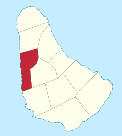
Map of Barbados showing the Saint James parish
Coordinates: 13°13′N59°37′W / 13.217°N 59.617°W / 13.217; -59.617
Country Barbados
Largest city Holetown
Government
  Type Parliamentary democracy
   Parliamentary  seats3
Area
  Total31 km2 (12 sq mi)
Population
 (2010 census)
  Total28,498
  Density920/km2 (2,400/sq mi)
ISO 3166 code BB-04 [1]

The parish of Saint James ("St. James") is an area located in the western central part of the country of Barbados. Increasingly St. James is becoming known as the playground of the rich and famous, and as a haven for sun-starved tourists with its up-market hotel resorts. [2]

Contents

In local colloquium, St. James was known as the "Gold Coast", but due to its ongoing popularity, it is now often referred to as the "Platinum Coast", reflective of the parish's many glitzy beach-front mansions, pristine beaches, luxury hotel resorts, and consistently high land prices.

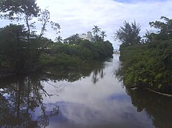
The parish also has great historic significance, as it was here that the first British settlers landed in 1625. Under the authority of King James, the British claimed Barbados upon landing in St. James' present-day town of Holetown (formerly known as Jamestown, named after the King himself); this settlement turned Barbados into what would later be known colloquially as "Little England".

Noted for its shopping and restaurants in Holetown, Saint James, is central to Barbados' bustling tourist industry,[ citation needed ] with historical attractions including the St. James Parish Church and the Portvale Sugar Factory, one of the few remaining operational sugar factories on the island.

Though the beach area is a haven for wealthy tourists and foreign expatriates, St. James as a whole is far from exclusive. As one of the bigger parishes of Barbados, it is home to over 20,000 nationals in its various districts, across various social strata. The parish is home to the prestigious Queen's College, one of the foremost schools not only in Barbados, but also the Caribbean, founded over a century ago by British plantation owner Colonel Henry Drax. At its most rural, the parish's many villages (such as the seafront Fitts Village) are abuzz with activity, near-familial camaraderie, and an active social atmosphere.

Geography

Populated places

The parish contains the following towns, villages, localities, settlements, hamlets and neighbourhoods:

Parishes bordering Saint James

Defined boundaries

Education

St. James is the home of five primary and two secondary schools. Secondary school are the Queen's College in Husbands and the Fredrick Smith Secondary School in Holetown.

Primary schools are in Fitts Village (Good Shepherd Primary), Orange Hill (St. Silas Primary), Trents (St. James Primary), West Terrace (West Terrace Primary) and Weston (St. Albans Primary).

Related Research Articles

<span class="mw-page-title-main">St. John's, Saint John</span> Capital of Antigua and Barbuda

St. John's is the capital and largest city of Antigua and Barbuda, part of the West Indies in the Caribbean Sea. With a population of 22,219, St. John's is the commercial centre of the nation and the chief port of the island of Antigua.

<span class="mw-page-title-main">Bridgetown</span> Capital of Barbados

Bridgetown is the capital and largest city of Barbados. Formerly The Town of Saint Michael, the Greater Bridgetown area is located within the parish of Saint Michael. Bridgetown is sometimes locally referred to as "The City", but the most common reference is simply "Town". As of 2014, its metropolitan population stands at roughly 110,000.

<span class="mw-page-title-main">Saint Michael, Barbados</span> Parish in Barbados

The parish of St. Michael is one of eleven parishes of Barbados. It has a land area of 39 km2 (15 sq mi) and is found at the southwest portion of the island. Saint Michael has survived by name as one of the original six parishes created in 1629 by Governor Sir William Tufton.

<span class="mw-page-title-main">Avalon (electoral district)</span> Federal electoral district in Newfoundland and Labrador, Canada

Avalon is a federal electoral district on Newfoundland Island in Newfoundland and Labrador, Canada. It has been represented in the House of Commons of Canada since 2004.

<span class="mw-page-title-main">Holetown</span> City in Saint James, Barbados

Holetown, is a small city located in the Caribbean island nation of Barbados. Holetown is located in the parish of Saint James on the sheltered west coast of the island.

<span class="mw-page-title-main">Christ Church, Barbados</span> Parish in Barbados

The parish of Christ Church is one of eleven historic political divisions of Barbados. It has a land area of 57 km2 (22 sq mi) and is found at the southern end of the island. Christ Church has survived by name as one of the original six parishes created in 1629 by Governor Sir William Tufton.

<span class="mw-page-title-main">Saint Andrew, Barbados</span> Parish in Barbados

Saint Andrew is one of eleven parishes of Barbados. It is situated in the northeastern area in the country.

<span class="mw-page-title-main">Saint George, Barbados</span> Parish in Barbados

The landlocked parish of Saint George is located in the interior of Barbados. It is one of two land-locked parishes, the other being Saint Thomas to the north. A prominent landmark in the parish is Gun Hill Signal Station – one of the few remaining signal stations, dating back to 1818.

<span class="mw-page-title-main">Saint Lucy, Barbados</span> Parish in Barbados

The parish of Saint Lucy is the northernmost area in the country of Barbados. Saint Lucy is the only parish of Barbados out of the eleven to be named after a female patron saint, Saint Lucy of Syracuse. Saint Lucy's shape also resembles a peninsula, surrounded on three sides by the Atlantic Ocean to the north, east and west. The Harrison Point Lighthouse is located in Harrisons, Saint Lucy between Great Head and Norse's Bay, also in Saint Lucy. To the south lies the neighbouring Parish of Saint Peter.

<span class="mw-page-title-main">Saint Peter, Barbados</span> Parish in Barbados

The Parish of Saint Peter is one of eleven parishes in the Caribbean island country of Barbados. It is named after the Christian Apostle and patron saint, Saint Peter. It is located in the north of Barbados, and is the only parish besides Saint Lucy that extends from the east coast to the west.

<span class="mw-page-title-main">Legislative route (Minnesota)</span>

In the U.S. state of Minnesota, a legislative route is a highway number defined by the Minnesota State Legislature. The routes from 1 to 70 are constitutional routes, defined as part of the Babcock Amendment to the Minnesota State Constitution, passed November 2, 1920. All of them were listed in the constitution until a 1974 rewrite. Though they are now listed separately in §161.114 of the Minnesota Statutes, the definitions are legally considered to be part of the constitution, and cannot be altered or removed without an amendment. Legislative routes with numbers greater than 70 can be added or deleted by the legislature.

The Los Angeles City Council, 1889–1909, was the legislative body of Los Angeles, California, under the first charter of the city, granted by the Legislature in 1889. The first election under that charter was held on February 21, 1889, and the last on December 4, 1906.

The City of Bridgetown constituency is one of eleven (11) electoral districts in the Parish of St. Michael, and one thirty (30) nationally in Barbados. The Constituency covers a portion of the capital city Bridgetown. The district formed in 1843 is the first electoral district formed after the original eleven in the country. The first representative for the constituency was the national hero the Right Excellent Samuel Jackman Prescod. The member of parliament is Lt.Col. Jeffrey Bostic (Ret.) of the Barbados Labour Party from 2013. The seat is usually won by a slim margin.

Christ Church East is a constituency in the Christ Church area of Barbados represented in the House of Assembly of the Barbadian Parliament since 2018 by Wilfred Abrahams MP of the Barbados Labour Party.

Christ Church East Central is a constituency in the Christ Church area of Barbados. Since 2003, it has been represented in the House of Assembly of the Barbadian Parliament by Ronald Jones. Jones is a member of the DLP.

Christ Church South is a constituency in the Christ Church area of Barbados represented in the House of Assembly of the Barbadian Parliament since 2008 by Ralph A. Thorne MP of the BLP.

Christ Church West is a constituency in the Christ Church area of Barbados represented in the House of Assembly of the Barbadian Parliament since 2013 by Maria Agard MP of the BLP.

<span class="mw-page-title-main">Saint James Parish, New Brunswick</span> Parish in Canada

Saint James is a civil parish in Charlotte County, New Brunswick, Canada, located north of St. Stephen.

<span class="mw-page-title-main">Saint David Parish, New Brunswick</span> Parish in Canada

Saint David is a civil parish in Charlotte County, New Brunswick, Canada, located northeast of St. Stephen and northwest of Saint Andrews.

References

  1. iso:code:3166:BB, International Organization for Standardization
  2. Tyzack, Anna (19 February 2010). "Property in the Caribbean: Welcome to Barbados". The Daily Telegraph . Archived from the original on 22 February 2010. Retrieved 24 June 2010.
  3. 1 2 3 4 "Barbados, Chapter 108: Parish Boundaries (1986-18)". The Barbados Parliament. 1986-10-16. Retrieved 2023-04-04.