Outline of the British Virgin Islands

Last updated

The location of the British Virgin Islands LocationBritishVirginIslands.png
The location of the British Virgin Islands
An enlargeable map of the British Virgin Islands GB Virgin Islands.png
An enlargeable map of the British Virgin Islands

The following outline is provided as an overview of and topical guide to the British Virgin Islands:

Contents

British Virgin Islands (BVI) British overseas territory located in the eastern portion of the Virgin Islands Archipelago in the Caribbean Sea. [1] The Virgin Islands are part of the Leeward Islands of the Lesser Antilles. The United States Virgin Islands comprises the western portion of the archipelago. Technically the name of the Territory is simply the "Virgin Islands", but in practice since 1917 they have been almost universally referred to as the "British Virgin Islands" to distinguish the islands from the American Territory. [2] To add to the regional confusion, the Puerto Rican islands of Culebra, Vieques and surrounding islands began referring to themselves as the "Spanish Virgin Islands" as part of a tourism drive in the early 2000s.

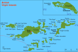
The British Virgin Islands consist of the main islands of Tortola, Virgin Gorda, Anegada and Jost Van Dyke, along with over fifty other smaller islands and cays. Approximately fifteen of the islands are inhabited. The largest island, Tortola, is approximately 20 km (approx. 12 mi) long and 5 km (approx. 3 mi) wide. The islands have a total population of about 22,000, of whom approximately 18,000 live on Tortola. Road Town, the capital, is situated on Tortola.

General reference

An enlargeable basic map of the British Virgin Islands BritishVirginIsland map.png
An enlargeable basic map of the British Virgin Islands

Geography of the British Virgin Islands

Geography of the British Virgin Islands

Environment of the British Virgin Islands

Natural geographic features of the British Virgin Islands

Regions of the British Virgin Islands

Regions of the British Virgin Islands

Ecoregions of the British Virgin Islands

List of ecoregions in the British Virgin Islands

Administrative divisions of the British Virgin Islands

Administrative divisions of the British Virgin Islands

Provinces of the British Virgin Islands

Provinces of the British Virgin Islands

Districts of the British Virgin Islands

Districts of the British Virgin Islands

Municipalities of the British Virgin Islands

Municipalities of the British Virgin Islands

Demography of the British Virgin Islands

Demographics of the British Virgin Islands

Government and politics of the British Virgin Islands

Politics of the British Virgin Islands

Branches of the government of the British Virgin Islands

Government of the British Virgin Islands

Executive branch of the government of the British Virgin Islands

Legislative branch of the government of the British Virgin Islands

Judicial branch of the government of the British Virgin Islands

Court system of the British Virgin Islands

Foreign relations of the British Virgin Islands

Foreign relations of the British Virgin Islands

International organization membership

The government of the British Virgin Islands is a member of: [1]

Law and order in the British Virgin Islands

Law of the British Virgin Islands

Military of the British Virgin Islands

Military of the British Virgin Islands

Local government in the British Virgin Islands

Local government in the British Virgin Islands

History of the British Virgin Islands

History of the British Virgin Islands

Culture of the British Virgin Islands

Culture of the British Virgin Islands

Art in the British Virgin Islands

Literature

Among the noted names in Virgin Islands literature are Alphaeus Osario Norman (1885-1942), Verna Penn Moll, Jennie Wheatley, and Patricia G. Turnbull. Their poetry and that of 22 other writers, including the fastly emerging poet and literary critic Richard Georges, can be found in Where I See the Sun – Contemporary Poetry in The Virgin Islands (Tortola, Virgin Gorda, Anegada, Jost Van Dyke), an anthology edited by Lasana M. Sekou in 2016. [4]

Sports in the British Virgin Islands

Sports in the British Virgin Islands

Economy and infrastructure of the British Virgin Islands

Economy of the British Virgin Islands

Education in the British Virgin Islands

Education in the British Virgin Islands

See also

British Virgin Islands

Related Research Articles

<span class="mw-page-title-main">British Virgin Islands</span> British Overseas Territory in the Caribbean

The British Virgin Islands (BVI), officially the Virgin Islands, is a British Overseas Territory in the Caribbean, to the east of Puerto Rico and the US Virgin Islands and north-west of Anguilla. The islands are geographically part of the Virgin Islands archipelago and are located in the Leeward Islands of the Lesser Antilles and part of the West Indies.

<span class="mw-page-title-main">Geography of the British Virgin Islands</span> Part of island group of the Caribbean Lesser Antilles

The British Virgin Islands (BVI) are one of three political divisions of the Virgin Islands archipelago located in the Lesser Antilles, between the Caribbean Sea and the North Atlantic Ocean. The BVI are the easternmost part of the island chain. The land area totals and comprises 16 inhabited and more than 20 uninhabited islands. The islands of Tortola, Anegada, Virgin Gorda and Jost van Dyke are the largest. Maritime claims include 12 nmi territorial sea and a 200 nmi exclusive fishing zone. In terms of land use, it is 20% arable land, 6.67% permanent crops and 73.33% other as of a 2005 figure. It has strong ties to nearby U.S. Virgin Islands and Puerto Rico.

<span class="mw-page-title-main">Virgin Islands</span> Island group of the Caribbean Leeward Islands

The Virgin Islands are an archipelago in the Caribbean Sea. They are geologically and biogeographically the easternmost part of the Greater Antilles, the northern islands belonging to the Puerto Rico Trench and St. Croix being a displaced part of the same geologic structure. Politically, the British Virgin Islands have been governed as the western island group of the Leeward Islands, which are the northern part of the Lesser Antilles, and form the border between the Caribbean Sea and the Atlantic Ocean. The archipelago is separated from the true Lesser Antilles by the Anegada Passage and from the main island of Puerto Rico by the Virgin Passage.

<span class="mw-page-title-main">History of the British Virgin Islands</span> Aspect of history

The History of the British Virgin Islands is usually, for convenience, broken up into five separate periods:

<span class="mw-page-title-main">Leeward Islands</span> Subgroup of islands in the West Indies

The Leeward Islands are a group of islands situated where the northeastern Caribbean Sea meets the western Atlantic Ocean. Starting with the Virgin Islands east of Puerto Rico, they extend southeast to Guadeloupe and its dependencies. In English, the term Leeward Islands refers to the northern islands of the Lesser Antilles chain. The more southerly part of this chain, starting with Dominica, is called the Windward Islands. Dominica was originally considered a part of the Leeward Islands, but was transferred from the British Leeward Islands to the British Windward Islands in 1940.

<span class="mw-page-title-main">Virgin Gorda</span> Island which is part of the British Virgin Islands

Virgin Gorda is the third-largest island and second-most populous of the British Virgin Islands (BVI).

<span class="mw-page-title-main">Anegada</span> Northernmost of the British Virgin Islands

Anegada is the northernmost of the British Virgin Islands (BVI), a group of islands that form part of the archipelago of the Virgin Islands. It lies approximately 15 miles (24 km) north of Virgin Gorda. Anegada is the only inhabited British Virgin Island formed from coral and limestone, rather than being of volcanic origin. While the other islands are mountainous, Anegada is flat and low. Its highest point is only about 28 feet (8.5 m) above sea level, earning it its name, which is the Spanish term for the flooded land, "tierra anegada".

<span class="mw-page-title-main">Tortola</span> Largest of the British Virgin Islands

Tortola is the largest and most populated island of the British Virgin Islands, a group of islands that form part of the archipelago of the Virgin Islands. It has a surface area of 55.7 square kilometres with a total population of 23,908, with 9,400 residents in Road Town. Mount Sage is its highest point at 530 metres above sea level.

<span class="mw-page-title-main">Terrance B. Lettsome International Airport</span> Airport in British Virgin Islands

Terrance B. Lettsome International Airport, previously known as Beef Island Airport, is the main airport serving the British Virgin Islands, a British overseas territory in the Caribbean. The airport serves as the gateway to just about all of the islands within the BVI. The airport is also a gateway for inter-Caribbean travelers headed to the nearby U.S. Virgin Islands. Many travellers fly into Beef Island, with the intention of taking a ferry to the other smaller British Virgin Islands. The airport is located on Beef Island, a small island off the main island of Tortola, to which it is connected by the Queen Elizabeth II Bridge.

Virgin Islander culture reflects the various peoples that have inhabited the present-day British Virgin Islands and the U.S. Virgin Islands throughout history. Although the territories are politically separate, they maintain close cultural ties.

<span class="mw-page-title-main">Outline of Anguilla</span> Overview of and topical guide to Anguilla

The following outline is provided as an overview of and topical guide to Anguilla:

<span class="mw-page-title-main">Outline of Aruba</span> Overview of and topical guide to Aruba

The following outline is provided as an overview of and introduction to Aruba:

<span class="mw-page-title-main">Outline of Montserrat</span> Overview of and topical guide to Montserrat

The following outline is provided as an overview of and topical guide to Montserrat:

<span class="mw-page-title-main">Outline of the Netherlands Antilles</span> Overview of and topical guide to the Netherlands Antilles

The following outline is provided as an overview of and topical guide to the Netherlands Antilles:

<span class="mw-page-title-main">Outline of the Collectivity of Saint Martin</span> Overview of and topical guide to the Collectivity of Saint Martin

The following outline is provided as an overview of and topical guide to the Collectivity of Saint Martin:

<span class="mw-page-title-main">Outline of the United States Virgin Islands</span> Overview of and topical guide to the United States Virgin Islands

The following outline is provided as an overview of and topical guide to the United States Virgin Islands:

Education in the British Virgin Islands is largely free and is a requirement for children ages 5 to 17. The British Virgin Islands has a total of 15 public primary schools and 4 secondary public schools. In addition to the public schools, there are 10 primary private schools and 3 secondary private schools. The school year is from September to June. The British Virgin Islands is a part of the British Overseas Territories and therefore the educational system is very similar to the traditional learning system in the United Kingdom. Primary schools are focused on establishing the basics of an academic curriculum and host students between the ages of 5 and 12. After the completion of primary school, students move on to secondary school and pre-university. Secondary school is for students between the ages of 13 and 17. Following the completion of secondary education, students may write their Caribbean Secondary Education Certificate. There are approximately 2,700 students who attend primary school for the first 7 years of their required education; however less than 1,800 students successfully finish the following 4 required years of secondary school and complete their certificate exam incorrect, https://bvinews.com/87-percent-success-in-grade-12-top-school-named/]. Students who chose to continue their education after the secondary education certificate may move on to an additional 2 years of schooling. Passing the exams entitles students the right to continue their studies even further at the University of the Virgin Islands. At the university, students can obtain associate, bachelors, and master's degrees in the departments of business, education, liberal arts and social sciences, or science and mathematic.

<span class="mw-page-title-main">Postage stamps and postal history of the British Virgin Islands</span>

The colony of the British Virgin Islands has issued its own stamps since 1866. The first Post Office was opened in Tortola in 1787. At the time postage stamps were not yet invented, and it was not until 1858 that a small supply of adhesive stamps issued by Great Britain depicting Queen Victoria were utilized by the local Post Office. These stamps were cancelled by an A13 postmark and are extremely rare so cancelled.

References

  1. 1 2 "British Virgin Islands". The World Factbook . United States Central Intelligence Agency. 3 July 2009. Retrieved 23 July 2009.
  2. British Virgin Islands government publications had traditionally continued to commence with "The Territory of the Virgin Islands", but recently, more and more legislation now simply refers to the Territory as the British Virgin Islands. The Interpretation Act (Cap 136) (1985) defines the "Territory" as simply the "Virgin Islands"; but the Insolvency Act, 2003 defines a "foreign company" as 'a body corporate that is incorporated, registered or formed outside the British Virgin Islands.'
  3. The Virgin Islands (Constitution) Order 1976
  4. "Virgin Islands Platinum News ... BVI Daily News You Can Count on".

Gnome-globe.svg Wikimedia Atlas of the British Virgin Islands

Official sites and overviews
Directories