
The Thompson River is the largest tributary of the Fraser River, flowing through the south-central portion of British Columbia, Canada. The Thompson River has two main branches, the South Thompson River and the North Thompson River. The river is home to several varieties of Pacific salmon and trout. The area's geological history was heavily influenced by glaciation, and the several large glacial lakes have filled the river valley over the last 12,000 years. Archaeological evidence shows human habitation in the watershed dating back at least 8,300 years. The Thompson was named by Fraser River explorer, Simon Fraser, in honour of his friend, Columbia Basin explorer David Thompson. Recreational use of the river includes whitewater rafting and angling.

Clearwater is a district municipality in the North Thompson River valley in British Columbia, Canada, where the Clearwater River empties into the North Thompson River. It is located 124 km (77 mi) north of Kamloops. The District of Clearwater was established on December 3, 2007, making it one of the newest municipalities in British Columbia. It is near Wells Gray Provincial Park and is surrounded by the Trophy Mountains, Raft Mountain and Dunn Peak.
Whitewater recreation in British Columbia is available in most of the province. Except for north-central and northeast British Columbia, the province is mostly mountainous with many glacial fed rivers draining though steep terrain creating excellent whitewater. Most commercial whitewater operations in British Columbia are rafting outfitters. However the provinces rivers are also well known to be good for whitewater kayaking, whitewater canoeing and river surfing although these activities are often done unguided.

The Fraser Canyon is a major landform of the Fraser River where it descends rapidly through narrow rock gorges in the Coast Mountains en route from the Interior Plateau of British Columbia to the Fraser Valley. Colloquially, the term "Fraser Canyon" is often used to include the Thompson Canyon from Lytton to Ashcroft, since they form the same highway route which most people are familiar with, although it is actually reckoned to begin above Williams Lake at Soda Creek Canyon near the town of the same name.

The Vedder River, called the Chilliwack River above Vedder Crossing, is a river in the Canadian province of British Columbia and the U.S. state of Washington.

Barriere is a district municipality in central British Columbia, Canada, located 66 km (41 mi) north of the larger city of Kamloops on Highway 5. It is situated at the confluence of the Barrière River and North Thompson Rivers in the Central North Thompson Valley.

The Clearwater River is the largest tributary of the North Thompson River, joining it at the community of Clearwater, British Columbia. The Clearwater rises from glaciers in the Cariboo Mountains and flows in a mostly southerly direction for 201 km (125 mi) to the North Thompson. Its entire course, except the last 5 km (3 mi), is within Wells Gray Provincial Park. Its confluence with the North Thompson is protected by North Thompson River Provincial Park.
The Taseko River or Dasiqox in the original Chilcotin, is a tributary of British Columbia's Chilko River, a tributary of the Chilcotin River which joins the Fraser near the city of Williams Lake.
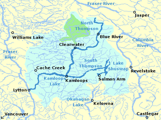
The South Thompson River is the southern branch of the Thompson River, the largest tributary of the Fraser River, in the Canadian province of British Columbia. It originates at the outlet of Little Shuswap Lake at the town of Chase and flows approximately 58 kilometres (36 mi) southwest and west through a wide valley to Kamloops where it joins the North Thompson River to form the main stem Thompson River.

Clearwater Lake is one of six large lakes in Wells Gray Provincial Park in east-central British Columbia, Canada,. The Clearwater River enters the lake at its north end, flowing from Hobson Lake and Azure Lake, and also drains the lake. There are several small streams that flow into Clearwater Lake, but it has no significant tributaries.
Major-General Arthur Reid Lempriere was a British Army officer of the Royal Engineers, including of the Royal Engineers, Columbia Detachment that founded British Columbia as the Colony of British Columbia (1858–1866).

Wells Gray Provincial Park is a large wilderness park located in east-central British Columbia, Canada. The park protects most of the southern, and highest, regions of the Cariboo Mountains and covers 5,415 square kilometres. It is British Columbia's fifth largest provincial park, after Tweedsmuir, Tatshenshini, Spatsizi and Northern Rocky Mountains.
Barrière River is a tributary of the North Thompson River, one of the main tributaries of the Fraser River, in the Canadian province of British Columbia. It flows through the Shuswap Highland region north of Kamloops. Its name in Secwepemctsín is St́yelltsecwétkwe.
The Raft River is a tributary of the North Thompson River, one of the main tributaries of the Fraser River, in the Canadian province of British Columbia. It flows through the Shuswap Highland region southeast of Wells Gray Provincial Park. Most of the Raft River's watershed lies outside the boundaries of Wells Gray, except for some of the headwaters of the West Raft River tributary.
Moonbeam Creek is a stream in Thompson-Nicola Regional District in the Interior region of British Columbia, Canada. It is in the Pacific Ocean drainage basin and is a left tributary of the North Thompson River. The nearest communities to the mouth of the creek on British Columbia Highway 5 are Blue River 40 kilometres (25 mi) south and Valemount 50 kilometres (31 mi) north; the mouth of the creek is just downstream of confluence of the North Thompson River and the Albreda River, where the North Thompson River turns 90° right and heads south.
The Albreda River is a river in Thompson-Nicola Regional District and the Regional District of Fraser-Fort George in the Interior region of British Columbia, Canada. It is in the Pacific Ocean drainage basin and is a left tributary of the North Thompson River. The nearest communities to the mouth of the creek on British Columbia Highway 5 are Blue River 42 kilometres (26 mi) south and Valemount 48 kilometres (30 mi) north; the mouth of the river is at a point where the North Thompson River, arriving downstream from its source, turns 90° right and heads south.
Canvas Creek is a stream in Kamloops Division Yale Land District in the Interior region of British Columbia, Canada. It is in the Pacific Ocean drainage basin and is a right tributary of the North Thompson River.

Mount Albreda is a mountain located in British Columbia, Canada.

