Related Research Articles
Samuel Black was a Scottish fur trader and explorer, a clerk in the New North Nest Company (XYC) and Wintering Partner in the North West Company (NWC), and later clerk, chief trader, and chief factor in the Hudson's Bay Company (HBC) for the Columbia District. In 1824, he explored the Finlay River and its tributaries in present-day north-central British Columbia, Canada, including the Muskwa, Omineca and Stikine for the HBC. His journals were published by the Hudson's Bay Record Society in 1955.
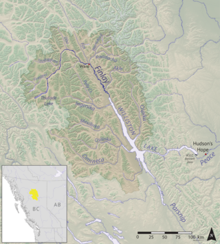
The Finlay River is a 402 km long river in north-central British Columbia flowing north and thence south from Thutade Lake in the Omineca Mountains to Williston Lake, the impounded waters of the Peace River formed by the completion of the W.A.C. Bennett Dam in 1968. Prior to this, the Finlay joined with the Parsnip River to form the Peace. The headwaters of the Finlay at Thutade Lake are considered the ultimate source of the Mackenzie River. Deserters Canyon is located just north of Williston Lake.
Thutade Lake is located in the Omineca Mountains of the Northern Interior of British Columbia, Canada. About 40 km (25 mi) in length, and no more than about 2 km (1.2 mi) wide, the lake is primarily significant as the ultimate source of the Mackenzie River. The lake is at the head of the Finlay River, which joins the Peace River via Williston Lake. The area is very remote, being located about 260 km (160 mi) north of Smithers, although several mining operations for ores containing copper, lead, zinc and silver have occurred around the lake. The largest of these is the Kemess Mine, an iron and copper property originally owned by Royal Oak Mines and now by Northgate Minerals, located in the valley of Kemess Creek, which is off the northeast end of Thutade Lake. The mine is accessed by the Omineca Resource Road and other resource routes, and is 400 km (250 mi) by road from Prince George. Just downstream from the outlet of Thutade Lake, the Finlay plunges over the 180-foot (55 m) Cascadero Falls, and then through a series of cataracts in a twisting course until it begins its main northeastward trend. Cascadero Falls is slated for hydroelectric development in connection with the power needs of the area's mines.
Gold Muchalat Provincial Park is a provincial park in British Columbia, Canada, located between the Gold and Muchalat Rivers.

Nuchatlitz Provincial Park is a provincial park in British Columbia, Canada, located on the northwest side of Nootka Island, facing Nuchatlitz Inlet, on the west coast of Vancouver Island. Established in 1996, the park contains approximately 2105 ha.
Spatsizi Plateau Wilderness Provincial Park is located in the northern portion of British Columbia, Canada, approximately 698, 659 hectares and encompasses the Spatsizi River and Gladys Lake Ecological Reserve. The park is a designated protected area that is intended for the conservation and research on caribou, grizzly bears, fish, and other wildlife species populations. Before the provincial park's establishment in 1975, the area was a historical hunting ground for local Indigenous communities like the Tahltan First Nations.It is the second largest provincial park in British Columbia.
Tatlatui Provincial Park is a provincial park in British Columbia, Canada, located at the southern end of the Spatsizi Plateau and around the headwaters of the Firesteel River, part of the Finlay-Peace River basin and therefore in the Arctic drainage. Thutade Lake, at the head of the Firesteel and to the southeast of the park, is considered the ultimate source of the Mackenzie River.
Todagin South Slope Provincial Park is a provincial park in British Columbia, Canada, located on the west side of Todagin Creek to the east of Kinaskan Lake in the Stikine Country, to the south of the community of Dease Lake. Created in 2001, it contains c. 3557 ha.
The Omineca Mountains, also known as "the Ominecas", are a group of remote mountain ranges in the Boreal Cordillera of north-central British Columbia, Canada. They are bounded by the Finlay River on the north, the Rocky Mountain Trench on the east, the Nation Lakes on the south, and the upper reaches of the Omineca River on the west. They form a section of the Continental Divide, that, in this region, separates water drainage between the Arctic and Pacific Oceans. The lower course of the Omineca River flows through the heart of the range. To the south of the Ominecas is the Nechako Plateau, to the west the Skeena Mountains and Hazelton Mountains, to the north the Spatsizi Plateau and the Stikine Ranges, while east across the Rocky Mountain Trench are the Muskwa Ranges.
The Stikine Ranges are a group of mountain ranges and mountainous plateaus in northwestern British Columbia, Canada. They are the northernmost subdivision of the Cassiar Mountains and among the least explored and most undeveloped parts of the province.
The Tatlatui Range is a large and very alpine mountain range on the east flank of the upper Skeena River in northern British Columbia, Canada. It has an area of 2307 km2 and is a subrange of the Omineca Mountains which in turn form part of the Interior Mountains. The range features several lakes, the largest of which, Thutade Lake, is at the head of the Finlay River, and is considered the ultimate source of the Mackenzie River. Tatlatui Lake, the next largest lake in the range, to the northwest of Thutade Lake, is at the head of the Firesteel River, a tributary of the Finlay. Various summits of the range, which as described separates the Pacific and Arctic drainages, form part of the Continental Divide. Most of the range and its lakes are in Tatlatui Provincial Park.
The Gataga River is a river in the Northern Rockies of British Columbia, Canada. It is a tributary of the Kechika River, which is a tributary of the Liard.
Tyoax Pass is a mountain pass in the Chilcotin Ranges of the Pacific Ranges, the southernmost main subdivision of the Coast Mountains of British Columbia, Canada. Located at the head of Tyaughton Creek, a north tributary of the Bridge River, it connects the basin of the Bridge River with that of Big Creek in the southern Chilcotin District, and is therefore at the boundary between the Spruce Lake Protected Area and Big Creek Provincial Park.
Tatlatui Lake is a lake in the Tatlatui Range of the Omineca Mountains of the Northern Interior of British Columbia, Canada. It is the source of the Firesteel River, the uppermost left tributary of the Finlay River, which begins just southeast at Thutade Lake, which is considered the ultimate source of the Mackenzie River. The lake and adjoining summits are part of Tatlatui Provincial Park.
Cascadero Falls is a waterfall on the Finlay River in the Northern Interior of British Columbia, Canada, located just below that river's head at the outlet of Thutade Lake. The height of the falls is 180 ft and below it there are numerous cascades or rapids in a twisting course prior to the river's general northeastward trend from this area. The falls are slated for hydroelectric development in connection with the area's mines, the largest of which is the Kemess Mine owned by Northgate Minerals Inc., located just east of the foot of Thutade Lake in the valley of Kemess Creek.
The Toodoggone River is a tributary of the Finlay River in the Northern Interior of British Columbia, Canada, flowing east into the upper reaches of the Finlay just south of the Fishing Lakes. At the head of the Toodoggone is Metsantan Pass, which is at the divide with the Stikine River basin and also on the spine of the Continental Divide.

The Tsay Keh Dene First Nation is one of the Sekani bands of the Northern Interior of British Columbia. Tsay Keh Dene means "People of the Mountain". While they have an office in the City of Prince George, their territories, settlements, and Indian Reserves are all to the north, in the area of Williston Lake, whose creation as part of the W. A. C. Bennett Dam project flooded a large part of their territory with devastating effects on the people and their way of life.
Chase River is a neighbourhood in the south end of the city of Nanaimo, British Columbia, Canada on the east coast of Vancouver Island. It is named for the Chase River which runs through the community.
The Kingcome Range is a subrange of the Pacific Ranges of the Coast Mountains, located to the east of Kingcome Inlet.
The Mosque River is a tributary of the Skeena River in the Stikine Region of the province of British Columbia, Canada. It originates in the Tatlatui Range of the Skeena Mountains, and flows southwest about 50 km (31 mi) to the Skeena River, about 140 km (87 mi) north of Hazelton and about 160 km (99 mi) east of Stewart. Its watershed covers about 148 2 (57 sq mi), and its mean annual discharge is 15.4 m3/s (540 cu ft/s).
References
57°08′00″N126°55′00″W / 57.13333°N 126.91667°W