Cayoosh Creek

Last updated
Cayoosh Creek
Cayoose Creek
Cayoosh-creek.jpg
Cayoosh Creek
Etymologywild ponylocal variant of "cayoose", which ultimately is from Spanish caballo, referring to a certain mountain breed of horse
Location
Country Canada
Province British Columbia
District Lillooet Land District
Physical characteristics
Source Cayoosh Range
  location Coast Mountains
Mouth Seton River
  location
Lillooet
  coordinates
50°40′7″N121°58′21″W / 50.66861°N 121.97250°W / 50.66861; -121.97250 [1]
  elevation
229 m (751 ft) [2]
Basin size885 km2 (342 sq mi) [3]
Discharge 
  location mouth [3]
  average13.9 m3/s (490 cu ft/s) [3]
  minimum0.377 m3/s (13.3 cu ft/s)
  maximum211 m3/s (7,500 cu ft/s)

Cayoosh Creek is a northeast-flowing tributary of the Seton River in the Canadian province of British Columbia. The name Cayoosh Creek remains on the bridge-sign crossing the stream on BC Highway 99 and continues in use locally to refer to the final reaches of the Seton River, formerly Seton Creek, [4] which prior to the renaming ending at the confluence with Cayoosh Creek. The creek is the namesake of Cayoosh Creek Indian Reserve No. 1, [5] one of the main Indian reserves of the Cayoose Creek Indian Band (aka the Sekwelwas First Nation), which lies adjacent to what was renamed the Seton River without local consultation.

Contents

Course

Cayoosh Creek flows generally northeast from sources in the eponymous Cayoosh Range north of Cayoosh Pass to join the Seton River at Lillooet, British Columbia. [1] In local parlance, the 4 kilometre length of the Seton River to its confluence with the Fraser River at the town of Lillooet is referred to as Cayoosh Creek, as is indicated by a Department of Highways sign on the BC Highway 99 bridge crossing it just before the Bridge of the Twenty-Three Camels over the Fraser, which lies immediately upstream of the river's mouth.

Cayoosh Canyon

Although already 10 km long when it enters Duffey Lake, a 20-kilometre (12 mi) long lake which is the focus of its upper basin, at the lake's outflow it begins a rapid descent, carving deeply between the Cayoosh Range and the main Lillooet Ranges to the south. Duffey Lake is named for "Sapper Duffy", a Lieut. Patrick Duffey (or "Duffy") or the Royal Engineers, who was assigned to investigate the route of the Cayoosh valley as a possible wagon road from the head of Lillooet Lake to Lillooet, which because of the steep descent westwards from Cayoosh Pass was not gone forward with. The creek's final descent to the confluence with the Seton is a deeper and deeper canyon, narrow and twisting, with the last ridges of the Cayoosh Range forming a rock wall thousands of feet in height, immediately opposite the highway across a very narrow gorge below. The north wall of the canyon was the location of the Golden Cache Mine, [6] which started a small regional rush in 1897-1901 and whose former mill buildings were in the depths of the canyon below the highway and whose workings were reached by ramparts beneath overhangs on the highest part of the canyon wall. Opposite it was the Ample Mine, also a gold mine in the same period. [7] This stretch of the canyon was the site of the hunt for First World War hero-turned-outlaw Frank Gott, who is commemorated by Gott Peak which is on the southern rim of the Cayoosh basin, on the divide separating it from the basin of the Stein River, which parallels it roughly to the south, and which is one of Cayoosh Creek's several large southern tributaries.

At the bottom of the canyon, as the highway clings to a mountain face some three thousand feet high, ranging from one to two thousand feet to the creek, steep below, there is a small private reservoir formed by a dam where Cayoosh Falls had once been known as Walden North. Walden North was a private estate and scientific research facility and manufacturing installation built by American uranium prospector Vernon Pick. From Cayoosh Falls to the Fraser was the scene of the Cayoosh Gold Rush of the 1880s, in which 300 Chinese gold miners were estimated by the local Government Agent to have taken out around $6 million in gold. [4] The creek's riverbed throughout this stretch was literally turned upside down and remains of Chinese gold-mills and gold-furnaces can be found near the Hydro campsite, as well as piles of washed rocks which are byproducts of Chinese mining methods.

"Nkoomptch"

Towering over the lower reaches of the canyon and Walden North as a large BC Hydro-run campground on the creek's final bottomlands near the Seton River, is Mount Brew. Brew is the highest in the northern Lillooet Ranges at 9970'; the elevation of the confluence is about 700', the edge of Brew's summit above, less than a mile to the south, is around 8800'. A buttress of Mount Brew lies to the southeast of the confluence, even closer and overhanging the lower Seton River, and features an 8000' near-sheer wall, while on the north across the Seton River are the last ramparts of Mission Ridge, reaching up to 6000' in this area, which is also the terminus of the Cayoosh Range. The combined gorge-walls of Seton Lake, the Cayoosh Range, Cayoosh Canyon, Mount Brew and its northward buttress, and the last buttress of Mission Ridge, form a large canyon complex ranging from 5000' to 7000' which also is a zone of extreme aridity and high summer temperatures, featuring lizards, cactus, and sagebrush. "Nkoomptch" is the historical name for this locality historically and means "water crossing over" in the St'at'imcets language. In this locality, Governor Seymour commissioned one of the Interior's three first flour mills in 1862, the others being at Big Bar 60 km up the Fraser, in times when the Lillooet District produced mostly grain, as a measure to secure food supplies for the Cariboo Gold Rush. A store was also located in this area, operated by Dan Hurley, a Lillooet rancher and hotelier, as this was the route of the wagon road from the foot of Seton Lake, the last water leg of the Douglas Road, into Lillooet. [8]

Cayoosh Creek's last reaches are unusual in that they are bridged by a canal, the Seton Canal, which is part of the last phase of the Bridge River Power Project and feeds a powerhouse on the Fraser just south of the Seton River's confluence.

Name

There are differing accounts over how the stream acquired its name. [1]

"Cayoosh" is the local form of "cayuse", and in the Lillooet and Chilcotin regions refers to a particular strain of Indian mountain pony [4]

The traditional indigenous name of the stream is said to be Tsammuk and/or Tsho-ha-mous. [1]

See also

Related Research Articles

<span class="mw-page-title-main">Lillooet</span> District municipality in British Columbia, Canada

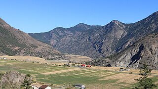
Lillooet is a district municipality in the Squamish-Lillooet region of southwestern British Columbia. The town is on the west shore of the Fraser River immediately north of the Seton River mouth. On BC Highway 99, the locality is by road about 100 kilometres (62 mi) northeast of Pemberton, 64 kilometres (40 mi) northwest of Lytton, and 172 kilometres (107 mi) west of Kamloops.

<span class="mw-page-title-main">Stʼatʼimc</span> Salishan ethnic group of British Columbia, Canada

The Stʼatʼimc, also known as the Lillooet, St̓át̓imc, Stl'atl'imx, etc., are an Interior Salish people located in the southern Coast Mountains and Fraser Canyon region of the Interior of the Canadian province of British Columbia.

<span class="mw-page-title-main">Seton Portage</span> Unincorporated community in British Columbia, Canada

Seton Portage is a community on a narrow strip of land between Anderson Lake and Seton Lake in Squamish-Lillooet Regional District, British Columbia. The community is home to two Seton Lake First Nation communities at either end of the portage and a non-native recreational community between them. Local services include a post office, fire department, library, and general store, among other small businesses. The community is also the location of Seton Portage Historic Provincial Park, a small provincial park protecting a historically significant stretch of railway.

Yale-Lillooet was a provincial electoral district for the Legislative Assembly of British Columbia, Canada.

<span class="mw-page-title-main">Fraser Canyon</span> Canyon in British Columbia, Canada

The Fraser Canyon is a major landform of the Fraser River where it descends rapidly through narrow rock gorges in the Coast Mountains en route from the Interior Plateau of British Columbia to the Fraser Valley. Colloquially, the term "Fraser Canyon" is often used to include the Thompson Canyon from Lytton to Ashcroft, since they form the same highway route which most people are familiar with, although it is actually reckoned to begin above Williams Lake at Soda Creek Canyon near the town of the same name.

<span class="mw-page-title-main">Bridge River</span> River in British Columbia, Canada

The Bridge River is an approximately 120 kilometres (75 mi) long river in southern British Columbia. It flows south-east from the Coast Mountains. Until 1961, it was a major tributary of the Fraser River, entering that stream about six miles upstream from the town of Lillooet; its flow, however, was near-completely diverted into Seton Lake with the completion of the Bridge River Power Project, with the water now entering the Fraser just south of Lillooet as a result.

<span class="mw-page-title-main">Lillooet Ranges</span> Mountain range in the country of Canada

The Lillooet Ranges are the southeasternmost subdivision of the Pacific Ranges of the Coast Mountains of British Columbia. They are located between the drainage of the Lillooet River and Harrison Lake on the west and the canyon of the Fraser River on the east, and by the lowland coastal valley of that river on the south.

<span class="mw-page-title-main">Cayoosh Range</span> Mountain range in the country of Canada

The Cayoosh Range is the northernmost section of the Lillooet Ranges, which are a subrange of the Pacific Ranges of the Coast Mountains in British Columbia, Canada. The range covers an area of c. 3770 km² and is approximately 65 km (40 mi) SW to NE and about 20 km (12 mi) SE to NW.

<span class="mw-page-title-main">Cayoosh Gold Rush</span> Gold Mining Canyon

The Cayoosh Gold Rush was one of several in the history of the region surrounding Lillooet, British Columbia, Canada. If estimates of its yield are true, it would be one of the richest single finds in the gold mining history of that province.

N'Quatqua, variously spelled Nequatque, N'quat'qua, is the proper historic name in the St'at'imcets language for the First Nations village of the Stl'atl'imx people of the community of D'Arcy, which is at the upper end of Anderson Lake about 35 miles southeast of Lillooet and about the same distance from Pemberton. The usage is synonymous with Nequatque Indian Reserve No. 1, which is 177 ha. in size and located adjacent to the mouth of the Gates River.

<span class="mw-page-title-main">Bridge River Power Project</span>

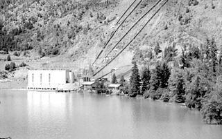
The Bridge River Power Project is a hydroelectric power development in the Canadian province of British Columbia, located in the Lillooet Country between Whistler and Lillooet. It harnesses the power of the Bridge River, a tributary of the Fraser, by diverting it through a mountainside to the separate drainage basin of Seton Lake, utilizing a system of three dams, four powerhouses and a canal.

<span class="mw-page-title-main">Okanagan Trail</span>

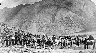
The Okanagan Trail was an inland route to the Fraser Canyon Gold Rush from the Lower Columbia region of the Washington and Oregon Territories in 1858–1859. The route was essentially the same as that used by the Hudson's Bay Company fur brigades, following the Columbia River to the confluence of the Okanogan River, and then up that river's watercourse via Osoyoos, Skaha (Dog) and Okanagan lakes, then using a pass via Monte Creek to Fort Kamloops, at the confluence of the North and South Thompson rivers. From there, the route went west down the Thompson River either to the lower gold-bearing bars of the Fraser River between what is now Lytton, British Columbia and Yale, British Columbia, or via Hat Creek and Marble Canyon to the upper Fraser goldfields around present-day Lillooet, British Columbia. A shorter branch-route to the lower Thompson and lower Fraser Canyon diverged from the main route at the confluence of the Similkameen River and the Okanogan. Cayoosh and The Fountains are today's Lillooet, British Columbia and environs.

Bridge River was used to describe three separate towns or localities in the Lillooet Country of the Interior of British Columbia connected with the river and valley of the same name.

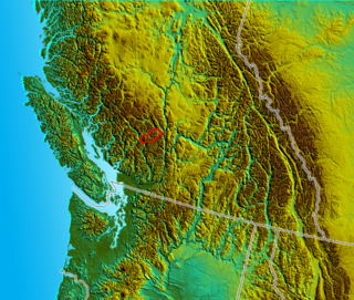
The Lillooet Country, also referred to as the Lillooet District, is a region spanning from the central Fraser Canyon town of Lillooet west to the valley of the Lillooet River, and including the valleys in between, in the Southern Interior of British Columbia. Like other historical BC regions, it is sometimes referred to simply as The Lillooet or even Lillooet,.

<span class="mw-page-title-main">Fountain, British Columbia</span>

Fountain is an unincorporated rural area and Indian reserve community in the Fraser Canyon region of British Columbia, Canada, located at the ten-mile (16 km) mark from the town of Lillooet on BC Highway 99, which in that area is also on the route of the Old Cariboo Road and is located at the junction of that route with the old gold rush-era trail via Fountain Valley and the Fountain Lakes.

Cayoosh Pass is a mountain pass in the Lillooet Ranges of the Pacific Ranges of the southern Coast Mountains in British Columbia, Canada. It lies just west of Duffey Lake on BC Highway 99 between the towns of Lillooet and Pemberton, formed by the headwaters of Cayoosh Creek to the east, flowing to the Fraser River at Lillooet, and Joffre Creek to the west, flowing steeply downhill to Lillooet Lake just southeast of the Mount Currie Indian Reserve.

McGillivray, formerly McGillivray Falls, is an unincorporated recreational community on the west shore of Anderson Lake, just east of midway between the towns of Pemberton and Lillooet, British Columbia, Canada, in that province's southwest Interior.

<span class="mw-page-title-main">Seton River</span> River in British Columbia, Canada

The Seton River is a tributary of the Fraser River in the Canadian province of British Columbia. The name is relatively new, and encompasses what had formerly been the Seton Portage River or Portage Creek and Seton Creek.

Mission Ridge, also known as Mission Mountain, is a ridge in the Bridge River-Lillooet Country of the South-Central Interior of British Columbia, Canada, extending westward from the town of Lillooet along the north side of Seton Lake to Mission Pass, which is immediately above and to the north of the lakeside community of Shalalth. The road over the pass is also known as Mission Mountain, which is short for "Mission Mountain Road". Mission Creek lies on the north side of the pass, and is a tributary of the Bridge River, the lower reaches of which lie on the north side of the ridge, and which was the only road access into the upper Bridge River Country before the construction of a road through the Bridge River Canyon in the mid-1950s opened that region up to road access from the lower Bridge River valley and the town of Lillooet via the community of Moha. Most, or virtually all, of the ridge, is Indian Reserves, notably Slosh 1, under the administration of the Seton Lake Indian Band, and Bridge River 1, which is under the administration of the Bridge River Indian Band. Parts of the ridge's eastern end are in reserves controlled by the Lillooet Indian Band, including its final spires above Lillooet, which were dubbed St. Mary's Mount by the Reverend Lundin Brown in the 1860s, though that name never stuck and is ungazetted.

The Bridge River Rapids, also known as the Six Mile Rapids, the Lower Fountain, the Bridge River Fishing Grounds, and in the St'at'imcets language as Sat' or Setl, is a set of rapids on the Fraser River, located in the central Fraser Canyon at the mouth of the Bridge River six miles north of the confluence of Cayoosh Creek with the Fraser and on the northern outskirts of the District of Lillooet, British Columbia, Canada.

References

  1. 1 2 3 4 "Cayoosh Creek". BC Geographical Names .
  2. Elevation derived from ASTER Global Digital Elevation Model, using GeoLocator, and BCGNIS coordinates
  3. 1 2 3 "Archived Hydrometric Data Search". Water Survey of Canada. Archived from the original on 24 December 2010. Retrieved 21 August 2013. Search for Station 08ME002 Cayoosh Creek near Lillooet
  4. 1 2 3 Tales from Seton Portage, Irene Edwards, self-publ., Lillooet 1976
  5. BC Names/GeoBC entry "Cayoosh Creek 1 (Indian reserve)"
  6. BC MINFILE Record Summary No. 092HNW048, GOLDEN CACHE, GEM GROUP
  7. BC MINFILE Record Summary No. 092JNE069, AMPLE (L.335), BEV, GEM (L.525), GOLDMAX, AMPLE GOLDMAX, ARTHUR NOEL, GOLDEN CACHE, COUGAR, AMPLE-GOLDMAX
  8. Halfway to the Goldfields: A History of Lillooet, Lorraine Edwards, Sunfire Press, 1972