Related Research Articles
Mica Dam, a hydroelectric dam spanning the Columbia River 135 kilometres north of Revelstoke, British Columbia, Canada, was built as one of three Canadian projects under the terms of the 1964 Columbia River Treaty and is operated by BC Hydro. Completed in 1973 under the terms of the treaty, the Mica powerhouse had an original generating capacity of 1,805 megawatts (MW). Mica Dam, named after the nearby settlement of Mica Creek and its associated stream, in turn named after the abundance of mica minerals in the area, is one of the largest earthfill dams in the world. The reservoir for the dam is Kinbasket Lake, which was created when the dam was built. Water from the dam flows south directly into Revelstoke Lake, the reservoir for the Revelstoke Dam. Mica Dam is the tallest dam in Canada and second tallest in North America after the Chicoasén Dam in Mexico and it is the farthest upstream dam on the Columbia River. The dam's underground powerhouse was the second largest in the world at the time of its construction, and was the first 500 kV installation of sulphur hexafluoride (SF6) insulated switchgear in the world.

The Pit River is a major river draining from northeastern California into the state's Central Valley. The Pit, the Klamath and the Columbia are the only three rivers in the U.S. that cross the Cascade Range.

The Feather River is the principal tributary of the Sacramento River, in the Sacramento Valley of Northern California. The river's main stem is about 73 miles (117 km) long. Its length to its most distant headwater tributary is just over 210 miles (340 km). The main stem Feather River begins in Lake Oroville, where its four long tributary forks join together—the South Fork, Middle Fork, North Fork, and West Branch Feather Rivers. These and other tributaries drain part of the northern Sierra Nevada, and the extreme southern Cascades, as well as a small portion of the Sacramento Valley. The total drainage basin is about 6,200 square miles (16,000 km2), with approximately 3,604 square miles (9,330 km2) above Lake Oroville.

The Colorado-Big Thompson Project is a federal water diversion project in Colorado designed to collect West Slope mountain water from the headwaters of the Colorado River and divert it to Colorado's Front Range and plains. In Colorado, approximately 80% of the state's precipitation falls on the West Slope, in the Rocky Mountains, while around 80% of the state's growing population lives along the East Slope, between the cities of Fort Collins and Pueblo.

The Klamath Project is a water-management project developed by the United States Bureau of Reclamation to supply farmers with irrigation water and farmland in the Klamath Basin. The project also supplies water to the Tule Lake National Wildlife Refuge, and the Lower Klamath National Wildlife Refuge. The project was one of the first to be developed by the Reclamation Service, which later became the Bureau of Reclamation.

The Bridge River is an approximately 120 kilometres (75 mi) long river in southern British Columbia. It flows south-east from the Coast Mountains. Until 1961, it was a major tributary of the Fraser River, entering that stream about six miles upstream from the town of Lillooet; its flow, however, was near-completely diverted into Seton Lake with the completion of the Bridge River Power Project, with the water now entering the Fraser just south of Lillooet as a result.

Seton Lake is a freshwater fjord draining east via the Seton River into the Fraser River at the town of Lillooet, about 22 km (14 mi) long, 26.2 km2 (10.1 sq mi) in area and lies at an elevation of 243 m (797 ft). Its depth is 460 m (1,500 ft).
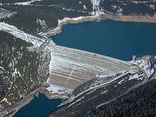
Terzaghi Dam is the key diversion dam in BC Hydro's Bridge River Power Project. It forms the project's largest reservoir, Carpenter Lake west of Lillooet. Originally known as the Mission Dam, it was renamed Terzaghi Dam in 1965 to honor Karl von Terzaghi, the civil engineer who founded the science of soil mechanics. It is located about 30 km up the Bridge River from its confluence with the Fraser.

Lajoie Dam is the uppermost of the storage dams of BC Hydro's Bridge River Power Project, which is located in the southwestern Interior of British Columbia. It is located just west of the small semi-ghost town of Gold Bridge. An earthfill structure, it is 87 m and impounds c. 570,000 acre feet (700,000,000 m3) of water in Downton Lake Reservoir. The Lajoie Powerhouse generates 22 MW with an average generating capacity of 170 GWh/year. A few miles downstream is Carpenter Lake, which is formed by Terzaghi Dam, the largest of the Bridge River Power Project's structures.

Carpenter Lake, officially Carpenter Lake Reservoir, is the largest of the three reservoirs of the Bridge River Power Project, which is located in the mountains west of Lillooet, British Columbia. The lake is about 185 kilometres north of the province's major city of Vancouver and is formed by the 1951 diversion of the Bridge River by Terzaghi Dam into Seton Lake via a tunnel through Mission Mountain, which separates the Seton and Bridge drainages. Several ranches and homesteads in the broad serpentine of the upper Bridge River basin were flooded out by the hydro project, which changed the character of the upper valley forever.
The Bridge River Power Project is a hydroelectric power development in the Canadian province of British Columbia, located in the Lillooet Country between Whistler and Lillooet. It harnesses the power of the Bridge River, a tributary of the Fraser, by diverting it through a mountainside to the separate drainage basin of Seton Lake, utilizing a system of three dams, four powerhouses and a canal.

The Bear River is a tributary of the Feather River in the Sierra Nevada, winding through four California counties: Yuba, Sutter, Placer, and Nevada. About 73 miles (117 km) long, the river flows generally southwest through the Sierra then west through the Central Valley, draining a narrow, rugged watershed of 295 square miles (760 km2).

The Jordan River Dam, officially the Jordan River Diversion Dam, and known locally simply as Diversion Dam, is a dam located in Jordan River, British Columbia, Canada. It is part of the second hydroelectric development on Vancouver Island.
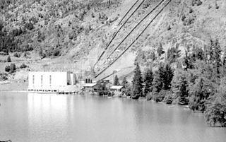
The Seton Powerhouse is a hydroelectric generating station on the Fraser River just below the confluence of the Seton River at the town of Lillooet, British Columbia, Canada. The powerhouse is fed by the Seton Canal, a 5 km diversion of the flow of the Seton River which begins at Seton Dam, just below the foot of Seton Lake to the west. The powerhouse is the last in sequence, and smallest, of the generating stations of BC Hydro's Bridge River Power Project, which diverts the flow of the Bridge River into Seton Lake. The powerhouse uses only 50 feet of head between Seton Lake and the Fraser to produce a maximum generating capacity of 42 MW and an average capacity of 330 GWh per year.
Seton Dam is a dam on the Seton River, 350m below the outlet of Seton Lake 5 km west of the town of Lillooet, British Columbia, Canada, and with the related Seton Canal is part of the lowest and last stage of BC Hydro's Bridge River Power Project. The 18-meter-high (59 ft) concrete dam, completed in 1956, raised the height of Seton Lake only 10 feet in order to maximize the elevation differential between that lake and the Fraser River in order to extract the maximal potential output of power generation at the Seton Powerhouse, which is located on the Fraser just south of the confluence of the Seton River proper.

Cayoosh Creek is a northeast-flowing tributary of the Seton River in the Canadian province of British Columbia. The name Cayoosh Creek remains on the bridge-sign crossing the stream on BC Highway 99 and continues in use locally to refer to the final reaches of the Seton River, formerly Seton Creek, which prior to the renaming ending at the confluence with Cayoosh Creek. The creek is the namesake of Cayoosh Creek Indian Reserve No. 1, one of the main Indian reserves of the Cayoose Creek Indian Band, which lies adjacent to what was renamed the Seton River without local consultation.

The North Fork Kings River is a 40.3-mile (64.9 km) tributary of the Kings River, in the U.S. state of California. The river's main stem is entirely within Fresno County, and its watershed drains about 387 square miles (1,000 km2) of the southern Sierra Nevada mountain range.

Ruskin Dam is a concrete gravity dam on the Stave River in Ruskin, British Columbia, Canada. The dam was completed in 1930 for the primary purpose of hydroelectric power generation. The dam created Hayward Lake, which supplies water to a 105 MW powerhouse and flooded the Stave's former lower canyon, which ended in a small waterfall approximately where the dam is today.

The Big Creek Hydroelectric Project is an extensive hydroelectric power scheme on the upper San Joaquin River system, in the Sierra Nevada of central California. The project is owned and operated by Southern California Edison (SCE). The use and reuse of the waters of the San Joaquin River, its South Fork, and the namesake of the project, Big Creek – over a vertical drop of 6,200 ft (1,900 m) – have over the years inspired a nickname, "The Hardest Working Water in the World".

The Upper North Fork Feather River Project is a hydroelectric scheme in the Sierra Nevada of California, within Lassen and Plumas Counties. The project consists of three dams, five power plants, and multiple conduits and tunnels in the headwaters of the North Fork Feather River, a major tributary of the Feather—Sacramento River systems. The total installed capacity is 362.3 megawatts (MW), producing an annual average of 1,171.9 gigawatt hours (GWh). The project is also contracted for the delivery of irrigation water between March 31 and October 31 of each year. The project is owned and operated by Pacific Gas and Electric Company.
References
Coordinates: 50°40′07″N121°57′09″W / 50.66861°N 121.95250°W
| This article about a location in the Cariboo Regional District, Canada is a stub. You can help Wikipedia by expanding it. |
| This article about a building or structure in British Columbia is a stub. You can help Wikipedia by expanding it. |