Pyramid Mountain (Alberta)

Last updated
Pyramid Mountain
View from Maligne Lookout 01.jpg
Pyramid from Maligne Lookout
Highest point
Elevation 2,766 m (9,075 ft) [1]
Prominence 761 m (2,497 ft) [2]
Listing Mountains of Alberta
Coordinates 52°57′04″N118°08′57″W / 52.95111°N 118.14917°W / 52.95111; -118.14917 Coordinates: 52°57′04″N118°08′57″W / 52.95111°N 118.14917°W / 52.95111; -118.14917 [3]
Geography
Canada Alberta relief location map - transverse mercator proj.svg
Red triangle with thick white border.svg
Pyramid Mountain
Location in Alberta
Location Alberta, Canada
Parent range Victoria Cross Ranges
Topo map NTS 83D/16 [3]
Climbing
First ascent George Kinney, guided by Conrad Kain [1]
Easiest route Scramble [4]

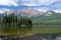
Pyramid Mountain is a mountain in Jasper National Park, Alberta, Canada, named for its pyramid-like shape. James Hector named the mountain in 1859 due to its appearance from the Athabasca River valley on the eastern side of the peak. [1]

Part of the Victoria Cross Ranges in the Athabasca River Valley the mountain is in the major headwaters for the Athabasca River. The peak is just under 10 km (6 mi) north-west of the town of Jasper.

The mountain is a relatively easy scramble on the eastern slopes. These slopes can be reached by following a steep fire road from the parking lot at Pyramid Lake, 11.5 km (7 mi) South-East of the peak. [4]

Based on the Köppen climate classification, Pyramid Mountain is located in a subarctic climate zone with cold, snowy winters, and mild summers. [5] Temperatures can drop below -20 °C with wind chill factors below -30 °C.

See also

Pyramid Mountain from Pyramid Lake, August 2012 Pyramid Mountain and Lake.jpg
Pyramid Mountain from Pyramid Lake, August 2012

Related Research Articles

Mount Columbia (Canada) Highest mountain in Alberta, Canada

Mount Columbia is a mountain located in the Winston Churchill Range of the Rocky Mountains. It is the highest point in Alberta, Canada, and is second only to Mount Robson for height and topographical prominence in the Canadian Rockies. It is located on the border between Alberta and British Columbia on the northern edge of the Columbia Icefield. Its highest point, however, lies within Jasper National Park in Alberta.

Sunwapta Peak

Sunwapta Peak is a peak located in the Sunwapta River valley of Jasper National Park, just north of the Columbia Icefield in Alberta, Canada. The peak was named in 1892 after the Stoney language word sunwapta meaning "turbulent river". The mountain can be seen from the Icefields Parkway.

Mount Wilcox (Alberta) Mountain in Jasper NP, Alberta, Canada

Mount Wilcox is a 2,884-metre (9,462-foot) mountain summit located in the Canadian Rockies of Alberta, Canada. It is located in Jasper National Park right beside the Columbia Icefield visitor centre with the Icefields Parkway traversing the western base of the mountain. Its nearest higher peak is Nigel Peak, 3.35 km (2.08 mi) to the northeast. Mount Wilcox is a moderate scramble from Wilcox Pass. Due to its location, it provides one of the best views of the Athabasca Glacier.

Brussels Peak

Brussels Peak is a 3,161-metre (10,371 ft) mountain summit located in the Athabasca River valley of Jasper National Park, in the Canadian Rockies of Alberta, Canada. The nearest higher peak is Mount Fryatt, 6.75 km (4.19 mi) to the northwest. Brussels Peak can be seen from the Icefields Parkway.

Mount Christie (Alberta)

Mount Christie is a 3,103-metre (10,180 ft) mountain summit located in the Athabasca River valley of Jasper National Park, in the Canadian Rockies of Alberta, Canada. The nearest higher peak is Brussels Peak, 1.67 km (1.04 mi) to the south-southwest. Mount Christie can be seen from the Icefields Parkway.

Gargoyle Mountain

Gargoyle Mountain is a 2,693-metre (8,835-foot) mountain summit located in Jasper National Park, in the Canadian Rockies of Alberta, Canada. The peak is situated 23 kilometres north of the municipality of Jasper, and is a prominent landmark in the Athabasca Valley visible from Highway 16 and the Canadian. Its nearest higher peak is Cliff Mountain, 5.5 km (3.4 mi) to the west. Gargoyle Mountain was named in 1916 by Morrison P. Bridgland for the fact a stream heads at the mountain, like a gargoyle or spout. Bridgland (1878-1948) was a Dominion Land Surveyor who named many peaks in Jasper Park and the Canadian Rockies. The mountain's name was officially adopted in 1956 by the Geographical Names Board of Canada.

Grisette Mountain

Grisette Mountain is a 2,620-metre (8,600 ft) mountain summit located in Jasper National Park in Alberta, Canada. It is located in the Colin Range, which is a sub-range of the Canadian Rockies. The peak is situated 14 km (8.7 mi) northeast of the municipality of Jasper, and is a prominent landmark in the Athabasca Valley visible from Highway 16 and the Canadian. Its nearest higher peak is Mount Dromore, 2.4 km (1.5 mi) to the east.

Nigel Peak

Nigel Peak is a 3,211-metre (10,535-foot) mountain summit located on the shared border of Banff National Park and Jasper National Park, in the Canadian Rockies of Alberta, Canada. Nigel has two peaks, the north summit is the highest point. The nearest higher peak is Mount Athabasca, 6.4 km (4.0 mi) to the south-southwest. Nigel Peak is situated immediately north of Sunwapta Pass and can be seen from the Icefields Parkway and from Athabasca Glacier.

Roche Miette

Roche Miette is a 2,316-metre (7,598-foot) mountain located at the northwestern tip of the Miette Range in Jasper National Park, in the Canadian Rockies of Alberta, Canada. The peak is a prominent landmark in the Athabasca Valley that is situated approximately thirty kilometres north-northeast of the municipality of Jasper, and four kilometres northeast of the Jasper House National Historic Site. It is visible from Highway 16 and the Canadian. Its nearest higher peak is Capitol Mountain, 5.0 km (3.1 mi) to the southeast. Roche Miette translates from French as Crumb Rock.

Karpathos Peak (Mount Olympus) Mountain in the Canadian Rockies

Karpathos Peak, also previously known as Mount Olympus, is a 2,987 metres (9,800 ft) mountain summit located in the Athabasca River valley of Jasper National Park, in the Canadian Rockies of Alberta, Canada. It is situated at the head of Fryatt Creek Valley on the same high ridge as Mount Christie, Brussels Peak, Mount Lowell, and Xerxes Peak. The nearest higher peak is Mount Belanger, 3.0 km (1.9 mi) to the north, and Kleodora Peak lies to the immediate northwest. Karpathos Peak can be seen from the Icefields Parkway, weather permitting.

Mount Tekarra

Mount Tekarra is a 2,694 metres mountain summit located in the Athabasca River valley of Jasper National Park, in the Canadian Rockies of Alberta, Canada. It is situated at the northwest end of the Maligne Range and is visible from Jasper and the Icefields Parkway. Its nearest higher neighbor is The Watchtower, 7.0 km (4.3 mi) to the east.

Kleodora Peak

Kleodora Peak is a 2,850 metres (9,350 ft) mountain summit located in the Athabasca River valley of Jasper National Park, in the Canadian Rockies of Alberta, Canada. It is situated at the head of Fryatt Creek Valley on the same high ridge as Mount Christie, Brussels Peak, Mount Lowell, Xerxes Peak, and Karpathos Peak. Its nearest higher peak is Parnassus Peak, 1.0 km (0.62 mi) to the north. The mountain was named for Kleodora, who in Greek mythology lived on Mount Parnassus. The name has not been officially adopted yet for this peak. An unnamed glacier lies below the eastern slope in the cirque between Kleodora Peak and Mount Belanger.

Hawk Mountain (Alberta)

Hawk Mountain is a 2,553-metre (8,376-foot) mountain summit located in Jasper National Park in Alberta, Canada. It is located near the northwest end of the Colin Range, which is a sub-range of the Canadian Rockies. The peak is situated 16 km (9.9 mi) northeast of the municipality of Jasper, and is a prominent landmark in the Athabasca Valley visible from Highway 16 and the Canadian. Its nearest higher peak is Mount Colin, 2.4 km (1.5 mi) to the southeast. Hawk Mountain was named in 1916 by Morrison P. Bridgland for the fact that a hawk was flying near the summit at the time it was named. Bridgland (1878-1948) was a Dominion Land Surveyor who named many peaks in Jasper Park and the Canadian Rockies. The mountain's name was officially adopted in 1956 by the Geographical Names Board of Canada.

The Whistlers

The Whistlers is a 2,470-metre (8,100-foot) mountain summit located in Jasper National Park, in the Trident Range of the Canadian Rockies of Alberta, Canada. The municipality of Jasper is situated 7 kilometres to the northeast. Its nearest higher peak is Indian Peak, 2.5 km (1.6 mi) to the southwest. The highest and longest aerial tramway in Canada ascends to a lookout at 2,277 meters elevation, still 193 meters below the summit, but a hiking trail continues to the summit. Some of the mountains that can be seen from the top include Mount Robson, Mount Bridgland, Monarch Mountain, Pyramid Mountain, Hawk Mountain, Mount Colin, Grisette Mountain, Mount Tekarra, Mount Hardisty, Mount Kerkeslin, Terminal Mountain, and Manx Peak.

Morro Peak

Morro Peak is a small 1,679-metre (5,509-foot) mountain summit located in Jasper National Park in Alberta, Canada. It is located at the northwest end of the Colin Range, which is a sub-range of the Canadian Rockies. The peak is situated 17 km (11 mi) north of the municipality of Jasper, and is a prominent landmark in the Athabasca Valley visible from Highway 16 and the Canadian. Its nearest higher peak is Hawk Mountain, 4.0 km (2.5 mi) to the southeast. Morro Peak was named in 1916 by Morrison P. Bridgland for the Spanish word morro, meaning rounded hill, which is an apt description of it. Bridgland (1878-1948) was a Dominion Land Surveyor who named many peaks in Jasper Park and the Canadian Rockies. The mountain's name was officially adopted in 1956 by the Geographical Names Board of Canada.

Evelyn Peak Mountain peak in Jasper NP, Alberta, Canada

Evelyn Peak is a 2,855 m (9,367 ft) mountain summit in the Athabasca River valley of Jasper National Park, in the Canadian Rockies of Alberta, Canada. THe nearest higher peak is Mount Kerkeslin, 5.0 km (3.1 mi) to the southwest, and Mount Hardisty is 6.0 km (3.7 mi) to the northwest. All three are part of the Maligne Range. Evelyn Peak is composed of sedimentary rock laid down during the Cambrian period and pushed east and over the top of younger rock during the Laramide orogeny. The mountain is at the headwaters of Evelyn Creek, and three kilometres south of Evelyn Pass. The creek and pass were named in 1921 for Evelyn Cavendish, Duchess of Devonshire (1870–1960), who visited nearby Maligne Lake in 1920. The mountain's name however, has not yet been officially adopted by the Geographical Names Board of Canada.

Mount Erebus (Canada)

Mount Erebus is a 3,112-metre (10,210-foot) mountain summit located near one of the most beautiful mountain meccas in the world, the Tonquin Valley of Jasper National Park in Alberta, Canada. Mount Erebus is composed of sedimentary rock laid down during the Cambrian period, then was pushed east and over the top of younger rock during the Laramide orogeny. Its nearest higher peak is Mount Fraser, 4.0 km (2.5 mi) to the northwest. The Continental Divide lies 3 km (1.9 mi) to the west, Angle Peak is situated 4.5 km (2.8 mi) to the southeast, and The Ramparts are 5.0 km (3.1 mi) to the north. The mountain's north ridge terminates at Outpost Peak.

Outpost Peak

Outpost Peak is a 2,880-metre (9,450-foot) double peak mountain located in the Tonquin Valley of Jasper National Park in Alberta, Canada. The northeast peak is identified on some maps as Outpost Peak, but the southwest peak is higher. Outpost Peak is composed of sedimentary rock laid down during the Cambrian period, then was pushed east and over the top of younger rock during the Laramide orogeny. Its nearest higher peak is Mount Erebus, 1.0 km (0.62 mi) to the south. The Continental Divide lies 3 km (1.9 mi) to the west, Angle Peak is situated 5.5 km (3.4 mi) to the southeast, and The Ramparts are 4.0 km (2.5 mi) to the north. The mountain's descriptive name was applied in 1921 by the Interprovincial Boundary Survey in keeping with the castle theme of the Ramparts area. The mountain's name was officially adopted in 1935 when approved by the Geographical Names Board of Canada.

Indian Ridge (Alberta)

Indian Ridge is a 2,820-metre (9,252 ft) mountain located in Jasper National Park, in the Trident Range of the Canadian Rockies of Alberta, Canada. The summit is unofficially called Indian Peak. The town of Jasper is situated 9 kilometres (5.6 mi) to the north-northeast, and The Whistlers lies 2.55 kilometres (1.58 mi) to the northeast. Its nearest higher peak is Manx Peak, 4.3 km (2.7 mi) to the southwest, and Terminal Mountain lies 3.25 km (2.02 mi) to the south. The Marmot Basin alpine ski area is located 4 kilometres (2.5 mi) to the southeast. The peak is composed of sedimentary rock laid down from the Precambrian to the Jurassic periods and pushed east and over the top of younger rock during the Laramide orogeny.

Throne Mountain

Throne Mountain is a prominent 3,120-metre (10,236 ft) mountain summit located in Jasper National Park, in the South Jasper Ranges of the Canadian Rockies of Alberta, Canada. It is situated 24 kilometres (15 mi) south of the town of Jasper, and 8 kilometres (5.0 mi) east of Tonquin Valley. The nearest higher neighbor is Mount Edith Cavell, 5.8 km (3.6 mi) to the east, and Franchère Peak lies 7.0 km (4.3 mi) to the northeast. The peak is composed of sedimentary rock laid down from the Precambrian to the Jurassic periods, that was pushed east and over the top of younger rock during the Laramide orogeny.

References

  1. 1 2 3 "Pyramid Mountain". PeakFinder.com. Retrieved 2019-09-06.
  2. "Pyramid Mountain". Bivouac.com. Retrieved 2009-01-02.
  3. 1 2 "Pyramid Mountain". Geographical Names Data Base. Natural Resources Canada . Retrieved 2019-09-06.
  4. 1 2 Kane, Alan (1999). "Pyramid Mountain". Scrambles in the Canadian Rockies . Calgary: Rocky Mountain Books. pp. 318–319. ISBN   0-921102-67-4.
  5. Peel, M. C.; Finlayson, B. L.; McMahon, T. A. (2007). "Updated world map of the Köppen−Geiger climate classification". Hydrol. Earth Syst. Sci. 11: 1633–1644. ISSN   1027-5606.