UNESCO Biosphere Reserves are environment-protected scientific-research institutions of international status that are created with the intent for conservation in a natural state the most typical natural complexes of biosphere, conducting background ecological monitoring, studying of the surrounding natural environment, its changes under the activity of anthropogenic factors.

Waterton Lakes National Park is in the southwest corner of Alberta, Canada. The national park borders Glacier National Park in Montana, United States. Waterton was the fourth Canadian national park, formed in 1895 as Kootenay Lakes Forest Reserve. It is named after Waterton Lake, in turn after the Victorian naturalist and conservationist Charles Waterton. Its range is between the Rocky Mountains and prairies. This park contains 505 km2 (195 sq mi) of rugged mountains and wilderness. It has a diverse ecosystem.

The San Francisco Peaks are a volcanic mountain range in the San Francisco volcanic field in north central Arizona, just north of Flagstaff and a remnant of the former San Francisco Mountain. The highest summit in the range, Humphreys Peak, is the highest point in the state of Arizona at 12,633 feet (3,851 m) in elevation. The San Francisco Peaks are the remains of an eroded stratovolcano. An aquifer within the caldera supplies much of Flagstaff's water while the mountain itself is in the Coconino National Forest, a popular recreation site. The Arizona Snowbowl ski area is on the western slopes of Humphreys Peak, and has been the subject of major controversy involving several tribes and environmental groups.

The Coconino National Forest is a 1.856-million acre United States National Forest located in northern Arizona in the vicinity of Flagstaff, with elevations ranging from 2,600 feet to the highest point in Arizona at 12,633 feet. Originally established in 1898 as the "San Francisco Mountains National Forest Reserve", the area was designated a U.S. National Forest by Pres. Theodore Roosevelt on July 2, 1908, when the San Francisco Mountains National Forest Reserve was merged with lands from other surrounding forest reserves to create the Coconino National Forest. Today, the Coconino National Forest contains diverse landscapes, including deserts, ponderosa pine forests, flatlands, mesas, alpine tundra, and ancient volcanic peaks. The forest surrounds the towns of Sedona and Flagstaff and borders four other national forests; the Kaibab National Forest to the west and northwest, the Prescott National Forest to the southwest, the Tonto National Forest to the south, and the Apache-Sitgreaves National Forest to the southeast. The forest contains all or parts of nine designated wilderness areas, including the Kachina Peaks Wilderness, which includes the summit of the San Francisco Peaks. The headquarters are in Flagstaff. The Coconino National Forest consists of three districts: Flagstaff Ranger District, Mogollon Rim Ranger District, and Red Rock Ranger District, which have local ranger district offices in Flagstaff, Happy Jack, and Sedona.

Barguzinsky Nature Reserve is the oldest of zapovedniks, established in 1916 for the protection of the Barguzin sable. It is located in Buryatia (Russia) on the west slope of the Barguzinsky Range, including the northeast shores of the Lake Baikal and a part of the lake itself. The area of the reserve is 2,482 km2 (958 sq mi), covering several types of boreal ecosystems, from bogs and taiga coniferous forests to subalpine meadows and mountain tundras. The landscape is postglacial, featuring rugged highlands, long river valleys and outwash, alluvial and lacustrine plains.
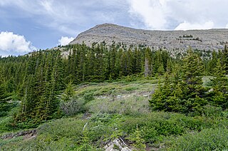
The Rocky Mountains subalpine zone is the biotic zone immediately below tree line in the Rocky Mountains of North America. In northern New Mexico, the subalpine zone occupies elevations approximately from 9,000 to 12,000 feet ; while in northern Alberta, the subalpine zone extends from 1,350 to 2,300 metres.

Waterton Lake is a mountain lake in southern Alberta, Canada, and northern Montana, United States. The lake is composed of two bodies of water, connected by a shallow channel known locally as the Bosporus. The two parts are referred to as Middle Waterton Lake, and Upper Waterton Lake, the latter of which is divided by the Canada–United States border with Canada containing about two thirds of the lake while the southern third falls in the United States. The Boundary Commission Trail ends at the lake as the last border marker was placed there on 8 August 1874. The United States Geological Survey gives the geocoordinates of 49°03′00″N113°54′03″W for Upper Waterton Lake. Lower Waterton Lake is north of Middle Waterton Lake and is separated by a channel known as the Dardanelles.
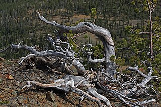
Krummholz — also called knieholz — is a type of stunted, deformed vegetation encountered in the subarctic and subalpine tree line landscapes, shaped by continual exposure to fierce, freezing winds. Under these conditions, trees can only survive where they are sheltered by rock formations or snow cover. As the lower portion of these trees continues to grow, the coverage becomes extremely dense near the ground. In Newfoundland and Labrador, the formation is known as tuckamore. Krummholz trees are also found on beaches such as the Oregon coast, where trees can become much taller than their subalpine cousins.

Pine Valley Mountain Wilderness is a 50,232-acre (203.28 km2) wilderness area located in the Dixie National Forest in the U.S. state of Utah. It is the fourth-largest wilderness area located entirely within the state. The wilderness designation protects the Pine Valley Mountain range, a large rock outcrop surrounded by desert. The Pine Valley Mountains form the Pine Valley Laccolith, one of the largest laccoliths in the United States. Elevations in the wilderness range from 6,000 feet (1,800 m) to 10,365 feet (3,159 m) at the summit of Signal Peak.

The wildlife of Canada or biodiversity of Canada consist of over 80,000 classified species, and an equal number thought yet to be recognized. Known fauna and flora have been identified from five kingdoms: protozoa represent approximately 1% of recorded species; chromist ; fungis ; plants ; and animals. Insects account for nearly 70 percent of documented animal species in Canada. More than 300 species are found exclusively in Canada.

The Baikal Nature Reserve is a nature reserve and "zapovednik" on the southeast shore of Lake Baikal, in southern Buryatia, Russia. Also called Baikal Zapovednik, it was established in 1969 for preserving the nature along the lake and the neighboring central part of the Khamar-Daban Range. The area of this nature reserve is 165,700 hectares [ha]. It hosts dark pine taiga, thin forests, Siberian Dwarf Pine and rhododendron underbrush, subalpine meadows, and alpine tundras. The Baikal Nature Reserve is home to 812 kinds of plants, 49 types of mammals, 272 birds, 3 reptiles, 3 amphibians, and 7 types of fish. The reserve is also home to East Siberian brown bear, Baikal lynx, wolverine, otter, osprey, and golden eagle. The Baikal Nature Reserve is part of the World Network of Biosphere Reserves. The reserve is also a part of the Lake Baikal World Heritage Site. The Kabansky Nature Zakaznik, across 12,100 ha, was transferred under the jurisdiction of the Baikal Nature Reserve in 1985.
The biogeoclimatic zones of British Columbia are units of a classification system used by the British Columbia Ministry of Forests for the Canadian province's fourteen different broad, climatic ecosystems. The classification system, termed Biogeoclimatic Ecosystem Classification, exists independently of other ecoregion systems, one created by the World Wildlife Fund and the other in use by Environment Canada, which is based on one created by the Commission for Environmental Cooperation (CEC) and also in use by the US Environmental Protection Agency (EPA). The system of biogeoclimatic ecosystem classification was partly created for the purpose of managing forestry resources, but is also in use by the British Columbia Ministry of Environment and Climate Change Strategy and other provincial agencies. A biogeoclimatic zone is defined as "a geographic area having similar patterns of energy flow, vegetation and soils as a result of a broadly homogenous macroclimate."

The ecology of the Rocky Mountains is diverse due to the effects of a variety of environmental factors. The Rocky Mountains are the major mountain range in western North America, running from the far north of British Columbia in Canada to New Mexico in the southwestern United States, climbing from the Great Plains at or below 1,800 feet (550 m) to peaks of over 14,000 feet (4,300 m). Temperature and rainfall varies greatly also and thus the Rockies are home to a mixture of habitats including the alpine, subalpine and boreal habitats of the Northern Rocky Mountains in British Columbia and Alberta, the coniferous forests of Montana and Idaho, the wetlands and prairie where the Rockies meet the plains, a different mix of conifers on the Yellowstone Plateau in Wyoming, the montane forests of Utah, and in the high Rockies of Colorado and New Mexico, and finally the alpine tundra of the highest elevations.

The Colorado Rockies forests is a temperate coniferous forest ecoregion of the United States. This ecoregion is located in the highest ranges of the Rocky Mountains, in central and western Colorado, northern New Mexico and southeastern Wyoming, and experiences a dry continental climate.

The Great Basin montane forests is an ecoregion of the Temperate coniferous forests biome, as designated by the World Wildlife Fund (WWF).
Niwot Ridge is an alpine ecology research station located 65 km northwest of Denver in north-central Colorado. It is on the Front Range of the southern Rocky Mountains and lies within the Roosevelt National Forest. Niwot Ridge is 2,900 metres (9,500 ft) high.

The Fraser Experimental Forest is an outdoor research laboratory to study timber, water, wildlife management, and their integration in the high elevation subalpine coniferous forests. The experimental forest was established in 1937, and encompasses 9,328 hectares (36.02 sq mi). It is situated on the west side of the Continental Divide in north-central Colorado and includes the entire watershed of main Saint Louis Creek, a tributary of the Fraser River.

Los Volcanes Biosphere Reserve is a UNESCO Biosphere Reserve located within the Trans-Mexican Volcanic Belt of south-central Mexico. The 171,774.4 hectares (663.225 sq mi) reserve surrounds the volcanoes of Popocatépetl and Ixtaccíhuatl and marks the biogeographical boundary between the Nearctic and Neotropical realms. The reserve is managed by Iztaccíhuatl Popocatépetl Zoquiapan National Park.

Castle Provincial Park is a provincial park in southern Alberta, Canada. It is located within the Municipal District of Pincher Creek No. 9 south of the Municipality of Crowsnest Pass, northwest of Waterton Lakes National Park and west of the Town of Pincher Creek. It shares a boundary with Castle Wildland Provincial Park to the west and south.

The Hermosa Creek Wilderness is a 37,236-acre (15,069 ha) U.S. Wilderness Area in La Plata County, Colorado. It s located in the San Juan National Forest 12 miles (19 km) north of Durango. It was established by the Hermosa Creek Protection Act of 2014, which also created the adjacent Hermosa Creek Special Management Area, which shares its eastern border, Hermosa Creek. Elevation in the wilderness ranges from 7,500 feet (2,300 m) along Hermosa Creek to 12,338 feet (3,761 m) at the high point of Indian Trail Ridge.