Mount Cory (Alberta)

Last updated
Mount Cory
Mount Cory (30006908068).jpg
Highest point
Elevation 2,802 m (9,193 ft) [1] [2]
Prominence 287 m (942 ft) [3]
Parent peak Mystic Peak [3]
Listing Mountains of Alberta
Coordinates 51°12′05″N115°41′20″W / 51.20139°N 115.68889°W / 51.20139; -115.68889 [1]
Geography
Canada Alberta relief location map - transverse mercator proj.svg
Red triangle with thick white border.svg
Mount Cory
Location in Alberta
Mount Cory (Alberta)
Interactive map of Mount Cory
Location Alberta, Canada
Parent range Sawback Range
Topo map NTS 82O4 Banff
Climbing
Easiest route Easy/Moderate Scramble [2]

Mount Cory is a mountain located in the Bow River Valley in southeast Banff National Park, just north of Banff, Alberta, Canada. The mountain was named in 1923 after William Wallace Cory, deputy minister of the Interior from 1905 to 1930. [1]

Contents

The "Hole in the Wall"

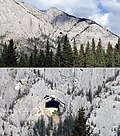
The gaping "Hole in the Wall" cave is located in the upper portion of the western side of Mount Cory. The cave is a landmark easily viewed from the nearby Trans-Canada Highway. The formation is natural, despite the seemingly regular pentagonal shape of its entrance as seen from a distance. The cave is about 60 feet high and 100 feet deep and has often been visited by climbers. [4]

Climate

Based on the Köppen climate classification, Mount Cory is located in a subarctic climate zone with cold, snowy winters, and mild summers. [5] Winter temperatures can drop below -20 °C with wind chill factors below -30 °C.

See also

Related Research Articles

<span class="mw-page-title-main">Mount Peechee</span> Mountain in Canada

Mount Peechee is the third highest peak of the Fairholme Range in Banff National Park. Mt. Peechee is located immediately southeast of Mount Girouard in the Bow River valley south of Lake Minnewanka.

<span class="mw-page-title-main">Mount Louis</span> Mountain in Banff NP, Canada

Mount Louis is a 2,682-metre (8,799-foot) mountain summit located in southeast Banff National Park in Alberta, Canada. It is part of the Sawback Range which is a subset of the Canadian Rockies.

<span class="mw-page-title-main">Mount Saskatchewan (Alberta)</span> Mountain in Banff National Park, Alberta, Canada

Mount Saskatchewan is a mountain located in the North Saskatchewan River valley of Banff National Park, in the Canadian Rockies of Alberta, Canada.

<span class="mw-page-title-main">Mount Hector (Alberta)</span> Mountain in Banff National Park, Alberta, Canada

Mount Hector is a 3,394-metre (11,135-foot) mountain summit located in the Bow River valley of Banff National Park, in the Canadian Rockies of Alberta, Canada. The mountain was named in 1884 by George M. Dawson after James Hector, a geologist on the Palliser expedition. The mountain is located beside the Icefields Parkway, 17 km (11 mi) north of Lake Louise.

<span class="mw-page-title-main">Pilot Mountain (Alberta)</span> Mountain in Banff National Park, Alberta, Canada

Pilot Mountain is a mountain in the Bow River valley of Banff National Park in Alberta, Canada. It is located southeast of Redearth Creek and directly west of the Trans-Canada Highway.

<span class="mw-page-title-main">East End of Rundle</span> Mountain in Alberta, Canada

East End of Rundle (EEOR) is a mountain located immediately west of the town of Canmore, Alberta and immediately west of the Spray Lakes road in the Canadian Rockies. Mount Rundle occupies the space between Canmore and Banff on the southwest side of the Trans-Canada Highway.

<span class="mw-page-title-main">Mount Astley</span> Mountain in Banff NP, Alberta, Canada

Mount Astley is a 2,869-metre (9,413-foot) mountain summit located in the Palliser Range of the Canadian Rockies in Alberta, Canada. It is situated in Banff National Park above Lake Minnewanka. It was named after Charles D'Oyley Astley, who ran the boat concession on the lake in the late 1800s.

<span class="mw-page-title-main">Mount Bourgeau</span> Mountain in Banff NP, Alberta, Canada

Mount Bourgeau is a 2,931-metre (9,616 ft) mountain located in the Massive Range of Banff National Park in Alberta, Canada. It was named by James Hector in 1860 after Eugène Bourgeau, a botanist with the Palliser Expedition. Bourgeau Lake sits at the foot of the mountain and is a popular hiking destination.

<span class="mw-page-title-main">Mount Brett</span> Mountain in Banff NP, Alberta, Canada

Mount Brett is a 2,984-metre (9,790-foot) summit located in the Massive Range of Alberta, Canada It is situated in Banff National Park, 20 km (12 mi) west of Banff townsite, in the Canadian Rockies. Its nearest higher peak is Mount Ball, 12.52 km (7.78 mi) to the west.

<span class="mw-page-title-main">Mount Brewster (Canada)</span> Mountain in Banff, Alberta, Canada

Mount Brewster is a 2,859-metre (9,380 ft) mountain summit located in the Vermilion Range of Banff National Park, in the Canadian Rockies of Alberta, Canada. Mount Brewster was named in 1929 by Tom Wilson after John Brewster who was the father of the Brewster family of Banff.

<span class="mw-page-title-main">Mount Olive (Canadian Rockies)</span> Mountain in Canada

Mount Olive is located N of the head of the Yoho River on the Continental Divide, on the Alberta-British Columbia border, in both Banff National Park and Yoho National Park. It lies on the eastern edge of the Wapta Icefield, and is part of the Waputik Mountains. It was named in 1898 by H.B. Dixon after his wife Dixon, Olive.

<span class="mw-page-title-main">Mount Perren</span> Mountain peak in Canada

Mount Perren is located on the border of Alberta and British Columbia on the Continental Divide. It was named in 1968 after Walter Perren, a Swiss climbing guide and Parks Canada service warden. The peak forms part of the backdrop to Moraine Lake in the Valley of the Ten Peaks of Banff National Park.

<span class="mw-page-title-main">Castleguard Mountain</span> Mountain in Alberta, Canada

Castleguard Mountain, also known as Mount Castleguard, is an isolated mountain located near the southern edge of the Columbia Icefield at the northern edge of Banff National Park in Alberta, Canada. In 1918, Irish land surveyor Arthur Oliver Wheeler named the mountain because of its castle-like appearance, which seemed to stand guard over the southern portion of the Columbia Icefield. Castleguard was first ascended in 1919 by the Interprovincial Boundary Commission, which determined the exact location of the boundary between British Columbia and Alberta along the continental divide.

Mount Currie is a 2,770-metre (9,090-foot) mountain summit located in the upper Spray River Valley of southern Banff National Park, in the Canadian Rockies of Alberta, Canada. Mount Currie's nearest higher peak is Red Man Mountain, 3.3 km (2.1 mi) to the southwest on the Continental Divide.

<span class="mw-page-title-main">Mount Murchison (Alberta)</span> Mountain in Banff NP, Alberta, Canada

Mount Murchison is a 3,348-metre (10,984 ft) mountain summit located at the convergence of the North Saskatchewan River valley and Mistaya River valley of Banff National Park, in the Canadian Rockies of Alberta, Canada. The main summit has two high points: the Southeast Peak is 3,348 m, whereas the Northwest Peak is 3,333 m and separated by 700 m distance. Its nearest higher peak is Mount Cline, 15.71 km (9.76 mi) to the north. Mount Murchison is situated immediately southeast of the confluence of the North Saskatchewan River, Mistaya River, and Howse River near Saskatchewan Crossing, where the Icefields Parkway intersects with the David Thompson Highway.

<span class="mw-page-title-main">Epaulette Mountain</span> Mountain in Banff NP, Alberta, Canada

Epaulette Mountain is a 3,094-metre (10,151-foot) mountain summit in Alberta, Canada.

<span class="mw-page-title-main">Cirrus Mountain</span> Mountain summit in Alberta, Canada

Cirrus Mountain is a 3,270-metre (10,730-foot) mountain summit located in the upper North Saskatchewan River valley on the shared boundary between Banff National Park and White Goat Wilderness Area, in the Canadian Rockies of Alberta, Canada. Cirrus Mountain is situated along the east side the Icefields Parkway midway between Saskatchewan Crossing and Sunwapta Pass. Topographic relief is significant as the summit rises 1,740 meters (5,708 ft) above the parkway in 3 km (1.9 mi). The nearest higher peak is Mount Stewart, 5.92 km (3.68 mi) to the north-northeast.

<span class="mw-page-title-main">Mount Thompson (Alberta)</span> Mountain in Banff NP, Alberta, Canada

Mount Thompson is a 3,089-metre (10,135-foot) mountain summit located four kilometres west of Bow Lake in Banff National Park, in the Canadian Rockies of Alberta, Canada. Its nearest higher peak is Mount Baker, 5.0 km (3.1 mi) to the west. Mount Thompson is situated east of the Wapta Icefield, and is a member of the Waputik Mountains. Mount Thompson can be seen from the Icefields Parkway at Bow Lake.

<span class="mw-page-title-main">The Mitre (Alberta)</span> Mountain in Banff NP, Alberta, Canada

The Mitre is a 2,850-metre (9,350-foot) mountain summit located in the Lake Louise area of Banff National Park, in the Canadian Rockies of Alberta, Canada. Its nearest higher peak is Mount Lefroy, 1.0 km (0.62 mi) to the west. Mount Aberdeen is 2.0 km (1.2 mi) to the north-northeast, Lefroy Glacier immediately north, Mitre Glacier southwest, and Paradise Valley to the southeast.

<span class="mw-page-title-main">Eagle Mountain (Alberta)</span> Mountain in Banff NP, Canada

Eagle Mountain is a 2,836-metre (9,304-foot) mountain summit located immediately northeast of the Banff Sunshine ski resort in Banff National Park of Alberta, Canada. The mountain's toponym was officially adopted in 1958 by the Geographical Names Board of Canada. The nearest higher neighbor is Mount Howard Douglas, 1.51 km (0.94 mi) to the south-southeast.

References

  1. 1 2 3 "Mount Cory". cdnrockiesdatabases.ca. Retrieved 2004-10-24.
  2. 1 2 Kane, Alan (1999). "Mount Cory". Scrambles in the Canadian Rockies . Calgary: Rocky Mountain Books. p. 203. ISBN   0-921102-67-4.
  3. 1 2 "Mount Cory". Bivouac.com. Retrieved 2010-02-20.
  4. "Historical image of hikers in entrance to Mount Cory "Hole in the Wall"". albertaonrecord.ca. Society of Alberta Archives. Retrieved 2019-06-11.
  5. Peel, M. C.; Finlayson, B. L. & McMahon, T. A. (2007). "Updated world map of the Köppen−Geiger climate classification". Hydrol. Earth Syst. Sci. 11 (5): 1633–1644. Bibcode:2007HESS...11.1633P. doi: 10.5194/hess-11-1633-2007 . ISSN   1027-5606.