Castle Mountain

Last updated
Castle Mountain
Castle Mountain.jpg
Captured from the Bow River bank
Highest point
Elevation 2,766 m (9,075 ft) [1]
Prominence 168 m (551 ft) [2]
Listing Mountains of Alberta
Coordinates 51°17′59″N115°55′21″W / 51.29972°N 115.92250°W / 51.29972; -115.92250 [1]
Naming
Native nameMiistukskoowa (Blackfoot)
Geography
Parent range Sawback Range (Canadian Rockies)
Topo map NTS 82O5 Castle Mountain
Climbing
First ascent 1884 by Arthur P. Coleman [1] [2]
Easiest route Moderate scramble (NE)

Castle Mountain (Blackfoot : Miistukskoowa) is a mountain located within Banff National Park in the Canadian Rockies, approximately halfway between Banff and Lake Louise. It is the easternmost mountain of the Main Ranges in the Bow Valley and sits astride the Castle Mountain Fault which has thrust older sedimentary and metamorphic rocks forming the upper part of the mountain over the younger rocks forming its base. The mountain's castellated, or castle-like, appearance is a result of erosive processes acting at different rates on the peak's alternating layers of softer shale and harder limestone, dolomite and quartzite.

Contents

The mountain was named in 1858 by James Hector for its castle-like appearance. From 1946 to 1979 it was known as Mount Eisenhower in honour of the World War II general Dwight D. Eisenhower. Public pressure caused its original name to be restored, but a pinnacle on the southeastern side of the mountain was named Eisenhower Tower. Located nearby are the remains of Silver City, a 19th-century mining settlement, and the Castle Mountain Internment Camp in which persons deemed enemy aliens and suspected enemy sympathizers were confined during World War I.

While looking nearly inaccessible from the Trans-Canada Highway, the peak can be ascended from the backside on the northeastern slopes. The trail to Rockbound Lake leads hikers around the eastern side. The massif contains several high points including Helena Ridge (2,862 m (9,390 ft)), Stuart Knob (2,850 m (9,350 ft)) and Television Peak (2,970 m (9,744 ft)), the latter being named for the TV repeater located on top. Technicians use a helicopter rather than hiking the long ascent to the top.

Geology

Castle Mountain above Rockbound Lake Castle Mtn. above Rockbound Lake.jpg
Castle Mountain above Rockbound Lake

Castle Mountain is the easternmost member of the Main Ranges in the Bow Valley. [3] Passing through the mountain is the Castle Mountain Fault, a thrust fault which separates it and the other nearby peaks of the Main Ranges from the Sawback Range to the northeast, the westernmost of the Front Ranges in the region. [4] [5] Castle Mountain's upper sections, including its cliff faces, consist of late Pre-Cambrian and Cambrian age sedimentary rocks such as limestone and shale along with some metamorphic quartzite. Originally deposited in an ancient shallow sea, these deposits were later thrust over younger layers of late Paleozoic and Mesozoic age which now form the forested, gently sloping, base of Castle Mountain. [3] [4] [6] It is an example of a castellated mountain in which erosion has sculpted a series of flat or gently sloping terraces composed of softer shale and sharp cliffs which reveal alternating layers of shale interspersed by harder layers of quartzite, dolomite and limestone. [3] [7]

First Nations land claim

On January 25, 2017, the Government of Canada and the Siksika Nation announced an agreement to settle a land claim in the region of Castle Mountain, known as Miistukskoowa to the Siksika. The agreement ended an outstanding claim dating back to the 1880s when land located at Castle Mountain was set aside as a timber berth for the use and benefit of the First Nation. The basis of the claim was that these lands were wrongfully taken from the First Nation in 1908 without their consent and without proper compensation. In 1911, these lands at Castle Mountain were added to Rocky Mountain Park, now known as Banff National Park. The agreement provides the Siksika Nation with approximately $123 million in financial compensation, the option to purchase on the open market up to 17,491 acres of land outside of the boundaries of Banff National Park and apply to Canada to have the lands added to its reserve, economic opportunities inside Banff National Park, and ongoing park access for cultural, traditional and educational purposes. First Nation members voted to approve the settlement on March 4, 2016. Canada gave its final approval on August 15, 2016. [8]

History

James Hector, who accompanied the Palliser Expedition, encountered Castle Mountain in August 1858 while leading a side expedition to find the headwaters of the Bow River. [9] He noted that it "...looks exactly like a gigantic castle" [10] and named it Castle Mountain. [11] He also made the first recorded ascent of its slopes, but is not believed to have reached its summit. [12] The official journal of the Palliser Expedition records his ascent:

At 1,000 feet above the valley, before we had got quite out of the woods, we came to a cliff, about 80 feet high, composed of quartzite and indurated sandstone of a pinkish hue; the beds were nearly horizontal, and as they seem to continue so all the way to the top of the mountain, which is at least 3,000 feet higher, these quartzites must be the lowest beds I saw. [...] Above the point is a grassy slope, having an inclination of 33°, and so slippery that it was only with great trouble that we got over it; it would seem to indicate the occurrence of some soft beds that have weathered into the slope. After this we reached the first of the cliff ranges that are so conspicuous from the valley below; it was composed of quartzite, passing into a conglomerate of pebbles of milk quartz and other rocks. When 2,000 feet above the valley we passed round to the N[orth] side of the mountain, and found that a deep valley separated it from a lower spur composed of splintery shale of a dull red colour. The mass of the mountain, which yet rose more than 2,000 feet above us, seemed to be composed of thick-bedded limestones, and these breaking away as the soft shales below them have been destroyed has given rise to the castellated appearance. [10]

The first climber to reach the top of Castle Mountain was Arthur P. Coleman, a professor at the University of Toronto, in 1884. [13] Lawrence Grassi and P. Cerutti, both from Canmore, were the first to climb Eisenhower Tower in 1926. [13]

In 1881, Joe Healy received some ore in trade from an Indigenous person which was discovered to contain a relatively high silver content. The following year he settled at Castle Mountain as a prospector. News of Healy's ore soon spread; others began to arrive and the settlement of Silver City, situated near Castle Mountain, quickly developed. It was already thriving when the Canadian Pacific transcontinental railroad was built through the area in 1884. [4] Over three thousand people lived there at its height, but it was almost entirely abandoned in 1885 because the mines failed to yield a significant profit. [9]

Situated nearby is Castle Mountain Internment Camp, a First World War internment camp where Ukrainian immigrants to Canada were confined. Life in the camps was often described as 'grim'; with its isolated location far from the roads of the time, the Castle Mountain camp was an ideal place to confine 'enemy aliens' and 'suspected enemy sympathisers'. [1] The forced labour of these men helped build much of the infrastructure of Banff National Park. Internees were held at the Cave & Basin site during the winter months.

Construction began in 1910 at Castle Junction on a highway connecting British Columbia to Calgary that would, upon its completion in the early 1920s, [14] make Castle Mountain more accessible to climbers, hikers and other tourists.

Castle Mountain's Eisenhower Tower rises from the mist above the Trans-Canada Highway. Castle Mountain Alberta with Eisenhower Tower.jpg
Castle Mountain's Eisenhower Tower rises from the mist above the Trans-Canada Highway.

At a meeting of the Ottawa Canadian Club in January 1946 at which World War II general Dwight D. Eisenhower was a guest speaker, Prime Minister Mackenzie King renamed Castle Mountain in his honour. [15] Alluding to Scotland's recent gift to Eisenhower of a castle, King said, "We haven't any ancient castles, but we have something more enduring, we have ancient mountains ... we have a mountain named Castle and we have thought that to change the name to Mount Eisenhower we would pay a tribute in the form of permanency expressing our admiration years after the castle in Scotland has completely disappeared." [16] Immediate reaction was mixed; many Banff residents approved, but a telegram sent to King in the name of "members of the ski clubs and climbing clubs of the Rocky Mountains" protested the "inappropriate name of Eisenhower Peak". [16] By the 1970s, increasing displeasure at the new name was being voiced by Banff area residents through petitions submitted to the Alberta Heritage Sites Board for the restoration of the original name. [11] A change of name was already planned by 1976, but its implementation was delayed to avoid causing offense on account of the United States Bicentennial commemorations taking place that year. [17] The mountain was officially renamed Castle Mountain in November 1979, [18] but an isolated pinnacle at the southeastern end was designated Eisenhower Tower. [9] [19]

Scramble route

While the peak presents a formidable challenge to climb when viewed from the highway, the mountain can be ascended by first hiking to Rockbound Lake which is located on the easier backside. A break in a cliff band provides access to a route above the lake. The ascent is a very long day when undertaken from the trailhead and can easily require 12 hours for a return trip. This cannot be shortened as random backcountry camping is not permitted in the area. [20] The Castle Mountain Hut on the southern side could be used but requires technical rock climbing skills and possibly a rope to access it. [21] While the normal scrambling route reached via Rockbound Lake is primarily a long slog, there is no discernible trail once one reaches the top of the "big hill" overlooking the lake and requires moderate scrambling abilities and a bit of route finding to ascend the gully leading to the upper bench. If pressed for time or a different objective, Helena Ridge is basically a scree slog straight up although a lingering snowfield in the gully above the big hill may provide some relief. Snow patches often linger on the upper routes even in late summer so an ice axe should be considered. [22]

Climbing routes

There are numerous rock climbing routes available on the mountain, [1] the most common routes being:

Related Research Articles

<span class="mw-page-title-main">Banff National Park</span> National park in Alberta, Canada

Banff National Park is Canada's oldest national park, established in 1885 as Rocky Mountains Park. Located in Alberta's Rocky Mountains, 110–180 kilometres (68–112 mi) west of Calgary, Banff encompasses 6,641 square kilometres (2,564 sq mi) of mountainous terrain, with many glaciers and ice fields, dense coniferous forest, and alpine landscapes. Provincial forests and Yoho National Park are neighbours to the west, while Kootenay National Park is located to the south and Kananaskis Country to the southeast. The main commercial centre of the park is the town of Banff, in the Bow River valley.

<span class="mw-page-title-main">Banff, Alberta</span> Town in Alberta, Canada

Banff is a town in Banff National Park, Alberta, Canada, in Alberta's Rockies along the Trans-Canada Highway, 126 km (78 mi) west of Calgary and 58 km (36 mi) east of Lake Louise, 1,400 to 1,630 m above sea level,

<span class="mw-page-title-main">Mount Edith Cavell</span> Mountain in Jasper National Park, Alberta, Canada

Mount Edith Cavell is a mountain in the Athabasca River and Astoria River valleys of Jasper National Park, and the most prominent peak entirely within Alberta.

<span class="mw-page-title-main">Mount Temple (Alberta)</span> Mountain in Banff NP, Canada

Mount Temple is a mountain in Banff National Park of the Canadian Rockies of Alberta, Canada.

<span class="mw-page-title-main">Mount Niblock</span> Mountain in Banff NP, Canada

Mount Niblock is a mountain in Banff National Park near Lake Louise, Alberta, Canada.

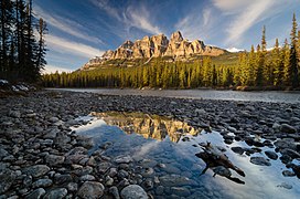
Castle Junction is a locality where the northern extent of the Banff–Windermere Highway intersects with the Trans-Canada Highway, the Bow River, and Bow Valley Parkway in Banff National Park, Alberta. It is named after the nearby Castle Mountain, clearly visible from the junction. The area is also referred to as Castle Mountain; however, the official location is approximately 1.6 km (1.0 mi) southwest of Castle Junction along the Canadian Pacific Railway.

<span class="mw-page-title-main">Ptarmigan Peak (Alberta)</span> Mountain in Alberta, Canada

Ptarmigan Peak is a peak located beside Pika Peak in Banff National Park, Alberta, Canada.

<span class="mw-page-title-main">Mount Rundle</span> Mountain in Banff National Park, Canada

Mount Rundle is a mountain in Canada's Banff National Park overlooking the towns of Banff and Canmore, Alberta. The Cree name was Waskahigan Watchi or house mountain. In 1858 John Palliser renamed the mountain after Reverend Robert Rundle, a Methodist invited by the Hudson's Bay Company to do missionary work in western Canada in the 1840s. He introduced syllabics there—a written language developed for the Cree, as part of his missionary work. He only visited the Stoney-Nakoda of the area around what is now called Mount Rundle in 1844 and 1847.

<span class="mw-page-title-main">The Three Sisters (Alberta)</span> Trio of mountains in Alberta, Canada

The Three Sisters are a trio of peaks near Canmore, Alberta, Canada. They are known individually as Big Sister, Middle Sister and Little Sister.

<span class="mw-page-title-main">Mount Hector (Alberta)</span> Mountain in Banff National Park, Alberta, Canada

Mount Hector is a 3,394-metre (11,135-foot) mountain summit located in the Bow River valley of Banff National Park, in the Canadian Rockies of Alberta, Canada. The mountain was named in 1884 by George M. Dawson after James Hector, a geologist on the Palliser expedition. The mountain is located beside the Icefields Parkway, 17 km (11 mi) north of Lake Louise.

<span class="mw-page-title-main">Castle Mountain Resort</span> Ski resort in Alberta, Canada

Castle Mountain is a ski resort located in the Westcastle Valley of southwest Alberta, Canada in the Rocky Mountains. It is approximately 270 kilometres (170 mi) from Calgary and the Calgary International Airport; 140 kilometres (87 mi) from Lethbridge; and 50 kilometres (31 mi) west of Pincher Creek. The resort is renowned for long steep runs and an average 9 metres (30 ft) of snowfall yearly.

Height of the Rockies Provincial Park is a provincial park in the Canadian Rockies of south eastern British Columbia, Canada. It is located west of the Continental Divide, adjacent to Elk Lakes Provincial Park.

<span class="mw-page-title-main">Southern Alberta</span> Region of Alberta, Canada (est. 1905)

Southern Alberta is a region located in the Canadian province of Alberta. In 2016, the region's population was approximately 291,112. The primary cities are Lethbridge and Medicine Hat. The region is known mostly for agricultural production, but other sectors, such as alternative energy, film production and tourism, are emerging.

<span class="mw-page-title-main">Tunnel Mountain</span> Mountain in Alberta, Canada

Tunnel Mountain, also known as Sleeping Buffalo, is a mountain located in the Bow River Valley of Banff National Park in Alberta, Canada at the junction of the Spray River with the Bow and overlooking the Hot Springs on Sulphur Mountain. The mountain is nearly completely encircled by the town of Banff and the Banff Springs Hotel grounds. For many Indigenous people, the Buffalo is not sleeping anymore since Banff National Park reintroduced wild bison in 2017.

<span class="mw-page-title-main">Mount Blakiston</span> Mountain in Alberta, Canada

Mount Blakiston is a mountain in the southwestern corner of Alberta, Canada and the highest point within Waterton Lakes National Park. The mountain is situated in the Clark Range, north of Lineham Creek and south of Blakiston Creek. Blakiston's closest neighbours include Mount Hawkins 2,685 m (8,809 ft) directly to the west along a connecting ridge and Mount Lineham 2,728 m (8,950 ft) to the south.

<span class="mw-page-title-main">Palliser Formation</span>

The Palliser Formation is a stratigraphic unit of Late Devonian (Famennian) age in the Western Canada Sedimentary Basin. It is a thick sequence of limestone and dolomitic limestone that is present in the Canadian Rockies and foothills of western Alberta. Tall cliffs formed of the Palliser Formation can be seen throughout Banff and Jasper National Parks.

<span class="mw-page-title-main">Yamnuska Mountain Adventures</span> Mountaineering school & adventure company

Yamnuska Mountain Adventures is a mountaineering school and mountain adventure company located in Canmore, Alberta, Canada. The company was founded in 1975.

<span class="mw-page-title-main">Castle Provincial Park</span> Provincial park in Alberta, Canada

Castle Provincial Park is a provincial park in southern Alberta, Canada. It is located within the Municipal District of Pincher Creek No. 9 south of the Municipality of Crowsnest Pass, northwest of Waterton Lakes National Park and west of the Town of Pincher Creek. It shares a boundary with Castle Wildland Provincial Park to the west and south.

<span class="mw-page-title-main">Pinnacle Mountain (Alberta)</span> Mountain in Banff NP, Canada

Pinnacle Mountain is a 3,070-metre (10,070-foot) mountain summit in Banff National Park in Alberta, Canada. It's part of the Bow Range, which is a sub-range of the Canadian Rockies. The nearest higher peak is Eiffel Peak, 1.0 km (0.62 mi) to the southwest. Mount Temple is situated immediately northeast of Pinnacle Mountain, with Sentinel Pass as the low point between the two.

<span class="mw-page-title-main">Ghost River (Alberta)</span> River in Alberta, Canada

The Ghost River is a river in Alberta, Canada. It begins within the front ranges of the Canadian Rocky Mountains, joining the Bow River at Ghost Lake. These waters flow through Cochrane, Calgary, and ultimately into Hudson Bay. The upper reaches of the Ghost are fully protected by the Ghost River Wilderness Area.

References

  1. 1 2 3 4 5 "Castle Mountain". cdnrockiesdatabases.ca. Retrieved 2019-08-11.
  2. 1 2 "Castle Mountain". Bivouac.com. Retrieved 2008-12-20.
  3. 1 2 3 Birrell, Dave (2000). 50 Roadside Panoramas in the Canadian Rockies. Rocky Mountain Books Ltd. p. 61. ISBN   9780921102656.
  4. 1 2 3 Luxton, Eleanor Georgina (2008). Banff: Canada's First National Park (2 ed.). Summerthought Publishing. p. 5. ISBN   9780978237547.
  5. Ivory, Michael (2006). National Geographic Traveler: Canada (2 ed.). National Geographic Books. p. 248. ISBN   9780792262015.
  6. Patton, Brian (2007). Parkways of the Canadian Rockies (5 ed.). Summerthought Publishing. p. 16. ISBN   9780978237523.
  7. Pashby, Christie (2007). Frommer's Banff & Jasper National Parks (4 ed.). John Wiley & Sons. p. 239. ISBN   9780470153468.
  8. "Canada and the Siksika Nation Advance Reconciliation with Signing of Castle Mountain Settlement". Indigenous and Northern Affairs Canada. January 25, 2017. Retrieved 2019-05-05.
  9. 1 2 3 Shea, Gerry (2010). The Aspiring Hiker's Guide 1: Mountain Treks in Alberta. Rocky Mountain Books Ltd. pp. 146–147. ISBN   9781897522790.
  10. 1 2 Palliser, John (1863). Exploration - British North America: The journals, detailed reports, and observations relative to the exploration, by Captain Palliser, of that portion of British North America, which, in latitude, lies between the British boundary line and the height of land or watershed of the northern or frozen ocean respectively, and in longitude, between the western shore of Lake Superior and the Pacific Ocean during the years 1857, 1858, 1859, and 1860. London: G.E. Eyre and W. Spottiswoode. pp. 101–102.
  11. 1 2 "Petitions are piling up over 'Castle Mountain'". Calgary Herald . Calgary, Alberta. 1975-02-03. p. 29. Retrieved 2012-09-22.
  12. "Banff residents want Eisenhower off historic mountain". Calgary Herald . Calgary, Alberta. 1975-01-20. p. 31. Retrieved 2012-09-22.
  13. 1 2 "Canmore Climber Led Way to Top of Peak". Calgary Herald . Calgary, Alberta. 1946-01-12. p. 1. Retrieved 2012-09-22.
  14. Liddell, Ken (1953-06-24). "Mountain Road Built to Fit the Contour". Calgary Herald . Calgary, Alberta. p. 14. Retrieved 2012-09-22.
  15. "Majestic Mount Eisenhower Is Home of Chinook Wind, Legend Claims". Ottawa Citizen . Ottawa, Ontario. 1946-01-11. p. 19. Retrieved 2012-09-22.
  16. 1 2 "Banff is Pleased Mountain Named After Eisenhower". Calgary Herald . Calgary, Alberta. 1946-01-11. p. 1. Retrieved 2012-09-22.
  17. "Eisenhower Mountain name change planned". Lawrence Journal-World . Lawrence, Kansas. 1976-04-07. p. 13. Retrieved 2012-09-22.
  18. "It's Castle Mountain Again". Milwaukee Sentinel . Milwaukee, Wisconsin. 1979-11-27. p. 2 (Part 3). Retrieved 2012-09-22.[ permanent dead link ]
  19. Boles, Glen W.; Laurilla, Roger W.; Putnam, William L. (2006). Canadian Mountain Place Names . Vancouver: Rocky Mountain Books. p.  58. ISBN   978-1-894765-79-4.
  20. Backcountry Trails in Banff National Park (PDF). Parks Canada. ISBN   978-0-660-24743-4. Archived from the original (PDF) on 2020-11-12. Retrieved 2020-01-20.
  21. "Castle Mountain Hut". Alpine Club of Canada. Retrieved 2020-01-20.
  22. Kane, Alan (1999). "Castle Mountain". Scrambles in the Canadian Rockies . Calgary: Rocky Mountain Books. pp. 209–212. ISBN   0-921102-67-4.