
Banff National Park is Canada's oldest national park, established in 1885 as Rocky Mountains Park. Located in Alberta's Rocky Mountains, 110–180 kilometres (68–112 mi) west of Calgary, Banff encompasses 6,641 square kilometres (2,564 sq mi) of mountainous terrain, with many glaciers and ice fields, dense coniferous forest, and alpine landscapes. The Icefields Parkway extends from Lake Louise, connecting to Jasper National Park in the north. Provincial forests and Yoho National Park are neighbours to the west, while Kootenay National Park is located to the south and Kananaskis Country to the southeast. The main commercial centre of the park is the town of Banff, in the Bow River valley.

The Canadian Rocky Mountain Parks World Heritage Site is located in the Canadian Rockies. It consists of seven contiguous parks including four national parks:

Kananaskis Country is a multi-use area west of Calgary, Alberta, Canada in the foothills and front ranges of the Canadian Rockies. The area is named for the Kananaskis River, which was named by John Palliser in 1858 after a Cree acquaintance. Covering an area of approximately 4,000 km2 (1,500 sq mi), Kananaskis Country was formed by the Alberta Government in 1978 to provide an assortment of land uses and designations. Land uses include resource extraction activities, recreation, power generation, and residential communities. Land designations include public land and protected areas.

The Bow River is a river in Alberta, Canada. It begins within the Canadian Rocky Mountains and winds through the Alberta foothills onto the prairies, where it meets the Oldman River, the two then forming the South Saskatchewan River. These waters ultimately flow through the Nelson River into Hudson Bay. The Bow River runs through the city of Calgary, taking in the Elbow River at the historic site of Fort Calgary near downtown. The Bow River pathway, developed along the river's banks, is considered a part of Calgary's self-image.
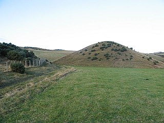
A kame, or knob, is a glacial landform, an irregularly shaped hill or mound composed of sand, gravel and till that accumulates in a depression on a retreating glacier, and is then deposited on the land surface with further melting of the glacier. Kames are often associated with kettles, and this is referred to as kame and kettle or knob and kettle topography. The word kame is a variant of comb, which has the meaning "crest" among others. The geological term was introduced by Thomas Jamieson in 1874.

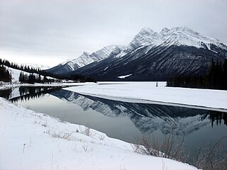
The Three Sisters are a trio of peaks near Canmore, Alberta, Canada. They are known individually as Big Sister, Middle Sister and Little Sister.
Alberta Provincial Highway No. 1, commonly referred to as Highway 1, is a major east–west highway in Southern Alberta that forms the southern mainline of the Trans-Canada Highway. It runs from the British Columbia border near Lake Louise through Calgary to the Saskatchewan border east of Medicine Hat. It continues as Highway 1 into both provinces. It spans approximately 534 km (332 mi) from Alberta's border with British Columbia in the west to its border with Saskatchewan in the east. The route is a divided 4-lane expressway throughout the province with the exception of a section in central Calgary where it is an arterial thoroughfare and Urban Boulevard carrying 4 to 6 lanes. The highway is a freeway between the Sunshine exit near the town of Banff and Home Road in Calgary. Other rural sections have at grade intersections with Interchanges only at busier junctions. Twinning of the final 8.5 km (5.3 mi) of Highway 1 between Lake Louise and the British Columbia border was completed by Parks Canada and opened to traffic on June 12, 2014 making the whole length of Alberta Highway 1 a divided minimum 4-lane route.

Bow Valley is a valley located along the upper Bow River in Alberta, Canada.

Alberta has been a tourist destination since the early days of the 20th Century, with attractions including national parks, National Historic Sites of Canada, urban arts and cultural facilities, outdoor locales for skiing, hiking and camping, shopping locales such as West Edmonton Mall, outdoor festivals, professional athletic events, international sporting competitions such as the Commonwealth Games and Olympic Winter Games, as well as more eclectic attractions.
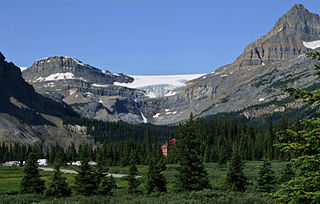
Bow Glacier is located in Banff National Park, Alberta, Canada, approximately 37 km (23 mi) northwest of Lake Louise. It can be viewed from the Icefields Parkway. Bow Glacier is an outflow glacier from the Wapta Icefield, which rests along the Continental Divide, and runoff from the glacier supplies water to Bow Lake and the Bow River. The glacier is credited for creating the Bow Valley before retreating at the end of the last glacial maximum.

Spray Valley Provincial Park is a provincial park located east of the Rocky Mountains, along the Spray River in western Alberta, Canada.

The Kananaskis River is a mountain river in western Alberta, Canada. It is a tributary of the Bow River, crossing the length of Kananaskis Country.
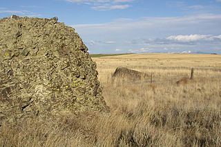
Sims Corner Eskers and Kames National Natural Landmark of Douglas County, Washington and nearby McNeil Canyon Haystack Rocks and Boulder Park natural landmarks contain excellent examples of Pleistocene glacial landforms. Sims Corner Eskers and Kames National Natural Landmark includes classic examples of ice stagnation landforms such as glacial erratics, terminal moraines, eskers, and kames. It is located on the Waterville Plateau of the Columbia Plateau in north central Washington state in the United States.
Alberta's Rockies comprise the Canadian Rocky Mountains in Alberta, Canada. On the southwestern part of the province along the British Columbia border, the region covers all but the south of Census Division 15.
Fluvioglacial landforms are those that result from the associated erosion and deposition of sediments caused by glacial meltwater. These landforms may also be referred to as glaciofluvial in nature. Glaciers contain suspended sediment loads, much of which is initially picked up from the underlying landmass. Landforms are shaped by glacial erosion through processes such as glacial quarrying, abrasion, and meltwater. Glacial meltwater contributes to the erosion of bedrock through both mechanical and chemical processes.
Spray Lakes Reservoir is a reservoir in Alberta, Canada. The Spray Lakes were a string of lakes formed along the Spray River, a tributary of the Bow River. With the damming of the river, the lakes were united in the Spray Lakes Reservoir.

Yamnuska Mountain Adventures is a mountaineering school and mountain adventure company located in Canmore, Alberta, Canada. The company was founded in 1975.
The Rocky Mountains Forest Reserve is a tract of land owned by the government of Canadian province of Alberta along the eastern slopes and foothills of the Albertan section of the Canadian Rockies. It is a long strip of land just east of the more famous Canadian Rocky Mountain parks, which is managed for forest and water conservation, public recreation, and industrial goals, rather than aesthetic and preservation goals as in the rocky mountain parks. Forest reserves were established for "...(1) the reserving of timber supplies, (2) the reserving of areas unsuited to agriculture so that they would not be homesteaded, and (3) the preserving of the water level in streams by conserving the timber on the upper watersheds." Government of Canada (1911). “All forest reserves are set aside and constituted for the conservation of the forests and other vegetation in the forests and for the maintenance of conditions favourable to an optimum water supply in those reserves.” Province of Alberta (2004)
Don Getty Wildland Provincial Park is a wildland provincial park in Kananaskis Country, Alberta, Canada. It was created on 24 July 2001 and has an area of 62,775 hectares. The park was named for the 11th premier of Alberta, Don Getty. The park was designated as part of the Special Places 2000: Alberta’s Natural Heritage initiative.


