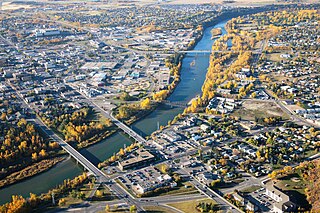
Red Deer is a city in Alberta, Canada, located midway on the Calgary–Edmonton Corridor. Red Deer serves central Alberta, and its key industries include health care, retail trade, construction, oil and gas, hospitality, manufacturing and education. It is surrounded by Red Deer County and borders on Lacombe County. The city is in aspen parkland, a region of rolling hills, alongside the Red Deer River.

Jasper National Park, in Alberta, Canada, is the largest national park within Alberta's Rocky Mountains, spanning 11,000 km2 (4,200 sq mi). It was established as Jasper Forest Park in 1907, renamed as a national park in 1930, and declared a UNESCO world heritage site in 1984. Its location is north of Banff National Park and west of Edmonton. The park contains the glaciers of the Columbia Icefield, springs, lakes, waterfalls and mountains.

The Athabasca River is a river in Alberta, Canada, which originates at the Columbia Icefield in Jasper National Park and flows more than 1,231 km (765 mi) before emptying into Lake Athabasca. Much of the land along its banks is protected in national and provincial parks, and the river is designated a Canadian Heritage River for its historical and cultural importance. The scenic Athabasca Falls is located about 30 km (19 mi) upstream from Jasper.

Kananaskis Country is a multi-use area west of Calgary, Alberta, Canada in the foothills and front ranges of the Canadian Rockies. The area is named for the Kananaskis River, which was named by John Palliser in 1858 after a Cree acquaintance. Covering an area of approximately 4,000 km2 (1,500 sq mi), Kananaskis Country was formed by the Alberta Government in 1978 to provide an assortment of land uses and designations. Land uses include resource extraction activities, recreation, power generation, and residential communities. Land designations include public land and protected areas.
Big Knife Provincial Park is a small provincial park in central Alberta, Canada. It is located at the confluence between Big Knife Creek and the Battle River between the villages of Donalda and Forestburg, 10 km south of Highway 53, 88 km from the city of Camrose.

Bow Valley Provincial Park is a provincial park in Alberta, Canada. Established in 1959 in the arch of the Bow River at its confluence with the Kananaskis River, the park is one park of many within the Kananaskis Country park system.
Carson-Pegasus Provincial Park is a provincial park located in central Alberta, Canada, within Woodlands County.
Cross Lake Provincial Park is a provincial park in Alberta, Canada, located 62 km (39 mi) west from Athabasca and 57 km (35 mi) north of Westlock.

Hamber Provincial Park is a provincial park in British Columbia, Canada, located 130 kilometres (80.7 mi) north of Golden. Straddling the Great Divide on the provincial boundary with Alberta, the park is surrounded on three sides by Jasper National Park and protects the headwaters of the Wood River at Fortress Lake.
Lakeland Provincial Park and Lakeland Provincial Recreation Area are located east of Lac La Biche, Alberta, Canada, in Lac La Biche County.

Greene Valley Provincial Park is a provincial park east of the Town of Peace River, Alberta, Canada, in Northern Sunrise County. It was designated a provincial park on June 6, 2000, by the Alberta provincial government.

The Northern Woods and Water Route is a 2,400-kilometre (1,500 mi) route through northern British Columbia, Alberta, Saskatchewan and Manitoba in Western Canada. As early as the 1950s, community groups came together to establish a northern travel route; this was proposed as the Northern Yellowhead Transportation Route. The Northern Woods and Water Route Association was established in 1974, and encouraged promotion of the route with the promise of an increase in tourist travel. The route was designated in 1974 and is well signed throughout its component highways. The route starts at Dawson Creek as the Spirit River Highway and ends at the Perimeter of Winnipeg, Manitoba, after running through the northern regions of the western provinces. From west to east, the Northern Woods and Water Route (NWWR) incorporates portions of British Columbia Highway 49; Alberta Highways 49, 2A, 2, & 55; Saskatchewan Highways 55 & 9; Manitoba Provincial Road 283 and Trunk Highways 10, 5, 68 & 6. The halfway point of the NWWR is approximately at Goodsoil, Saskatchewan.

Beaver River is a large river in east-central Alberta and central Saskatchewan, Canada. It flows east through Alberta and Saskatchewan and then turns sharply north to flow into Lac Île-à-la-Crosse on the Churchill River which flows into Hudson Bay.

Northern Alberta is a geographic region located in the Canadian province of Alberta.

Highway 21 is a provincial highway in the Canadian province of Saskatchewan. It runs from Montana Secondary Highway 233 at the United States border at Willow Creek to Highway 950 / Highway 919 within the Meadow Lake Provincial Park. Highway 21 is about 715 kilometres (444 mi) long.
Highway 55 is a paved, undivided provincial highway in the Canadian province of Saskatchewan. It runs from the Alberta border west of Pierceland to Highway 9 near Mountain Cabin. Highway 55 is about 652 kilometres (405 mi) long and forms part of the interprovincial Northern Woods and Water Route.

Ram Falls Provincial Park is a provincial park in Alberta, Canada, located 64 km (40 mi) south of Nordegg and 95 km (59 mi) west of Rocky Mountain House on Highway 734.
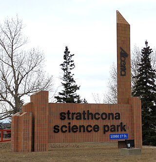
Strathcona Science Provincial Park is a provincial park in Alberta, Canada, located between Edmonton and Sherwood Park, south of the Yellowhead Highway and west of Anthony Henday Drive.
Birch Mountains Wildland Provincial Park is a wildland provincial park in northern Alberta, Canada. The park was established on 20 December 2000 with an area of 144,505 hectares. On 14 May 2018, the park was enlarged slightly to an area of 145,969 hectares. Thye park was created as part of Alberta's "Special Places" initiative. The park is contained in the Lower Athabasca Region Land Use Framework finalized in 2012. It contains a free roaming wood bison herd. The park is named for the Birch Mountains that are partially contained within the boundaries of the park.

Glenbow Ranch Provincial Park is a provincial park in the Calgary Region of Alberta, Canada. The majority of the park is located on the north bank of the Bow River within Rocky View County. Portions of the eastern and western extremities of the park are located within the City of Calgary and the Town of Cochrane respectively.