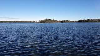
The park is located on the northeastern shore of the Lesser Slave Lake (while Hilliard's Bay Provincial Park, Lesser Slave Lake Wildland and Grouard Trail Park Reserve stand on the northwestern shore), 12 kilometres (7.5mi) north from the town of Slave Lake on Highway 88.
Marten Mountain Viewpoint overlooks the lake at an elevation of 983 metres (3,225ft). The Boreal Centre for Bird Conservation, an education and research centre, is also located in the park. The centre is a transit place for more than 246 bird species (including 23 species of wood warblers).
Lesser Slave Lake is located in northern Alberta, Canada, northwest of Edmonton. It is the second largest lake entirely within Alberta boundaries, covering 1,160 km2 (450 sq mi) and measuring over 100 km (62 mi) long and 15 km (9.3 mi) at its widest point. Lesser Slave Lake averages 11.4 m (37 ft) in depth and is 20.5 m (67 ft) at its deepest. It drains eastwards into the Athabasca River by way of the Lesser Slave River.
The Peace–Athabasca Delta, located in northeast Alberta, is the largest freshwater inland river delta in North America. It is located partially within the southeast corner of Wood Buffalo National Park, Canada's largest national park, and also spreads into the Regional Municipality of Wood Buffalo, west and south of the historical community of Fort Chipewyan. The delta encompasses approximately 321,200 ha, formed where the Peace and Athabasca rivers converge on the Slave River and Lake Athabasca. The delta region is designated a wetland of international importance and a UNESCO World Heritage Site. The region is large enough that it is considered one of twenty distinct natural subregions of Alberta by the provincial government's Natural Regions Committee.
Calling Lake Provincial Park is a provincial park in Alberta, Canada. It is a boreal forest reserve located 55 km (34 mi) north of Athabasca on Highway 813, and 186 km (116 mi) north of Edmonton, on the southern shore of Calling Lake. The marshy shores of the lake provide nesting grounds for waterfowl and habitat for American white pelicans and great blue herons.
Crimson Lake Provincial Park is a provincial park located in Alberta, Canada, 14 kilometres (8.7 mi) west of Rocky Mountain House, off the David Thompson Highway along secondary highway 756.
Hilliard's Bay Provincial Park is a provincial park in Alberta, Canada. It is located 40 km (25 mi) from High Prairie, on the north-western shore of Lesser Slave Lake in northern Alberta.
Saskatoon Island Provincial Park is a provincial park located in northern Alberta, Canada. It is located 20 kilometers (12 mi) west of Grande Prairie in the Peace River Country, on the southern shore of Saskatoon Lake.
Sir Winston Churchill Provincial Park is a provincial park located in east-central Alberta, Canada, on the shore of Lac la Biche. The park is renowned for its birdwatching and its old-growth forests. The park consists of multiple islands in the east basin of Lac la Biche. Big Island and Long Island are connected to the shore by a causeway, with Big Island being the largest island and making up most of the park. The other islands are only accessible by boat and remain undeveloped.
Wabasca, also known as Wabasca-Desmarais, is a hamlet in northern Alberta, Canada within the Municipal District (MD) of Opportunity No. 17. It is located between and along the South and North Wabasca Lakes, at the intersection of Highway 813 and Highway 754. It is approximately 123 km (76 mi) northeast of Slave Lake.
Northern Alberta is a geographic region located in the Canadian province of Alberta.
Jarvis Bay Provincial Park is a provincial park in Alberta, Canada, located 4 km (2.5 mi) north from Sylvan Lake and 35 km (22 mi) west from Red Deer, along Highway 20.
Manitou Lake is a salt lake located mostly in the RM of Manitou Lake No. 422 in the Canadian province of Saskatchewan, about 10 kilometres (6.2 mi) east of the provincial border with Alberta. The eastern shore of the lake is in the RM of Hillsdale No. 440. Manitou Lake is located in a region called the Prairie Pothole Region of North America, which extends throughout three Canadian provinces and five U.S. states. It is also within Palliser's Triangle and the Great Plains ecoregion. Manitou Lake is part of an Important Bird Area (IBA) of Canada that covers 699.66 km2 (270.14 sq mi) of land and serval neighbouring lakes.
The Boreal Plains Ecozone, as defined by the Commission for Environmental Cooperation (CEC), is a terrestrial ecozone in the western Canadian provinces of Manitoba, Saskatchewan and Alberta. It also has minor extensions into northeastern British Columbia and south-central Northwest Territories. The region extends over 779,471 km2, of which 58,981 km2 is conserved.
Grouard, also known as Grouard Mission, is a hamlet in northern Alberta within Big Lakes County. It was previously an incorporated municipality between 1909 and 1944.
Marten Beach is a hamlet in northern Alberta, Canada, within the Municipal District of Lesser Slave River No. 124. It is located on the northeast shore of Lesser Slave Lake, 2 kilometres (1.2 mi) west of Highway 88. It is approximately 36 kilometres (22 mi) north of the Town of Slave Lake and 238 kilometres (148 mi) northwest of the City of Edmonton.
The Mid-Canada Boreal Plains Forests is a taiga ecoregion of Western Canada, designated by One Earth. It was previously defined as the Mid-Continental Canadian Forests by the World Wildlife Fund (WWF) categorization system, before it was modified by One Earth, the successor to WWF.
Kazan Wildland Provincial Park is a wildland provincial park in northern Alberta, Canada. It was established on 14 May 2018 and is a large park with an area of 659,397 hectares (2,546 sq mi). As of January 2023, Kazan is the largest park under Alberta provincial authority. The park was initiated by and is contained in the Lower Athabasca Regional Plan Land Use Framework in August 2012. Two smaller parks, La Butte Creek and Colin-Cornwall Lakes Wildland Provincial Parks, were disestablished and incorporated into Kazan.
Sturgeon Bay Provincial Park is a provincial park on the western shore of Lake Winnipeg in Manitoba, Canada. The park is considered to be a Class Ib protected area under the IUCN protected area management categories. It is 144.9 km2 (55.9 sq mi) in size.
Grizzly Ridge Wildland Provincial Park is a wildland provincial park in northern Alberta, Canada. The park was established on 14 April 1999 and has an area of 10,706.07 hectares. The park is included in the Upper Athabasca Region Land Use Framework.
Lesser Slave Lake Wildland Provincial Park is a wildland provincial park in central Alberta, Canada. The park was established on 7 February 2001 and has an area of 3,581.450 hectares. The park is included in the Upper Athabasca Region Land Use Framework.
Winagami Wildland Provincial Park is a wildland provincial park in northern Alberta, Canada. The park was established on 26 August 1998 and has an area of 17,439.886 hectares. The park is included in the Upper Athabasca Region Land Use Framework. The park is named for Winagami Lake which is adjacent to the park.
This page is based on this Wikipedia article Text is available under the CC BY-SA 4.0 license; additional terms may apply. Images, videos and audio are available under their respective licenses.