Cold Lake Provincial Park

Last updated
Cold Lake Provincial Park
Cold Lake Provincial Park, Alberta campfire on beach.jpg
Alberta County Point Locator.svg
Red pog.svg
Location of Cold Lake Provincial Park in Alberta
Location Municipal District of Bonnyville No. 87, Alberta, Canada
Nearest city Cold Lake
Coordinates 54°28′16″N110°06′34″W / 54.47111°N 110.10944°W / 54.47111; -110.10944
Area62 km2 (24 sq mi)
EstablishedAugust 18, 1976
Governing body Alberta Tourism, Parks and Recreation

Cold Lake Provincial Park is a provincial park in northeastern Alberta, Canada.

Contents

It is located 3 kilometres (1.9 mi) east of the city of Cold Lake, on Highway 28, and extends to the Saskatchewan border.

The park protects the boreal forest in a number of designated areas on the southern and northern shores of Cold Lake, one of the largest lakes in Alberta. These shores are important nesting grounds for waterfowl.

The forest contains poplar, birch, spruce, and other types of wood.

The protected area is continued into Saskatchewan with the Meadow Lake Provincial Park.

Activities

Recreational facilities are located in the park including campground and day use areas. Camping, canoeing, fishing (and ice fishing), sailing, power boating and other water sports are popular activities. 11.5 km of trails are maintained in the park, and are used for hiking, mountain biking, cross-country skiing and show walking. [1]

Sport fishing is allowed in Cold Lake (brook stickleback, burbot, emerald shiner, fathead minnow, finescale dace, Iowa darter, lake trout, lake whitefish, logperch, longnose sucker, ninespine stickleback, northern pike, northern redbelly dace, slimy sculpin, spoonhead sculpin, spottail shiner, tullibee (cisco), walleye, white sucker, yellow perch) and Medley River (brook stickleback, burbot, emerald shiner, fathead minnow, finescale dace, lake chub, logperch, longnose sucker, northern redbelly dace, northern pearl dace, rainbow trout, spoonhead sculpin, spottail shiner, white sucker).

See also

Related Research Articles

<span class="mw-page-title-main">Ogoki River</span> River in Ontario, Canada

The Ogoki River is a river in the Thunder Bay and Cochrane Districts of Ontario. It springs from the wilderness just east of Savant Lake, flowing north of Lake Nipigon to Ogoki, where it joins the Albany River which empties into James Bay. The river is 480 kilometres (300 mi) long.

<span class="mw-page-title-main">Red Deer River</span> River in Alberta and Saskatchewan, Canada

The Red Deer River is a river in Alberta and a small portion of Saskatchewan, Canada. It is a major tributary of the South Saskatchewan River and is part of the larger Saskatchewan-Nelson system that empties into Hudson Bay.

Park Lake Provincial Park is a provincial park located in Alberta, Canada, 18 km (11 mi) north of Lethbridge.

<span class="mw-page-title-main">Dry Island Buffalo Jump Provincial Park</span> Provincial park in Alberta, Canada

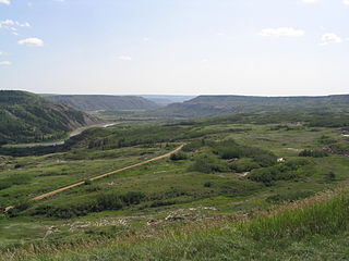
Dry Island Buffalo Jump Provincial Park is a provincial park in Central Alberta, Canada, located about 103 km (64 mi) southeast of Red Deer and 16 km (9.9 mi) east of Trochu. The park is situated along the Red Deer River and features badlands topography. Its name derives from the large plateau in the middle of the park, 200 m (660 ft) above the Red Deer River, which has never been developed by humans and retains virgin prairie grasses.

O'Brien Provincial Park is a provincial park in Alberta, Canada, located 15 km (9.3 mi) south from Grande Prairie, on Highway 666.

<span class="mw-page-title-main">Lake of Bays (Muskoka lake)</span>

Lake of Bays is a large lake in the District Municipality of Muskoka in Central Ontario, Canada. It is located almost entirely in the Township municipality of Lake of Bays, which is named after the lake, with the exception of the southwest arm of the lake which is in the Town of Huntsville. Ontario Highway 35 runs north and east of the lake.

Smoke Lake is a lake in northwest Alberta within the Municipal District of Greenview No. 16. It is located southwest of Fox Creek, approximately 9 km (5.6 mi) from Highway 43.

<span class="mw-page-title-main">Peace River Wildland Provincial Park</span>

Peace River Wildland Provincial Park is located in the valley of the Peace River stretching from Dunvegan Provincial Park to the Smoky River confluence and 30 kilometers upstream of the Smoky River valley. Also included in the park is the Spirit River valley at the confluence with the Peace. While most of the park lies in the Birch Hills County, some of it is in the Northern Sunrise County immediately south of the Town of Peace River.


Badger Creek is a stream in Houston County, in the U.S. state of Minnesota. It is a tributary of the South Fork Root River, which it meets east of Houston, Minnesota. Badger Creek was named for the badgers once common in the area.

<span class="mw-page-title-main">Raven River</span> River in Alberta, Canada

The Raven River or South Raven River is a major tributary of the Red Deer River located in Central-Western Alberta, Canada. The river is located in both the Clearwater County and Red Deer County.

<span class="mw-page-title-main">North Raven River</span> River in Canada

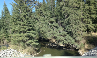
The North Raven River or Stauffer Creek is a major tributary of the Raven River located in western Central Alberta, Canada. It is located in the Red Deer River system. The river is a popular place for anglers.

References

  1. Alberta Tourism, Parks, Recreation & Culture. "Activities in Cold Lake Provincial Park" . Retrieved 2007-07-15.{{cite web}}: CS1 maint: multiple names: authors list (link)[ permanent dead link ]