The Bow River is a river in Alberta, Canada. It begins within the Canadian Rocky Mountains and winds through the Alberta foothills onto the prairies, where it meets the Oldman River, the two then forming the South Saskatchewan River. These waters ultimately flow through the Nelson River into Hudson Bay. The Bow River runs through the city of Calgary, taking in the Elbow River at the historic site of Fort Calgary near downtown. The Bow River pathway, developed along the river's banks, is considered a part of Calgary's self-image.
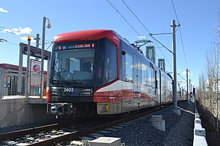
CTrain is a light rail rapid transit system in Calgary, Alberta, Canada. Much of the system functions as a high-capacity light metro, while in the downtown free-fare zone, trains run like a modern tram with a dedicated right-of-way. This subway-surface alignment is known as semi-metro.

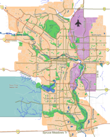
Nose Hill Park is a natural park in the northwest quadrant of Calgary, Alberta which covers over 11 km2 (4.2 sq mi). It is the fourth-largest urban park in Canada, and one of the largest urban parks in North America. It is a municipal park, unlike Fish Creek, which is a provincial park. It was created in 1980.

Bowness is a neighbourhood and former town in west Calgary, Alberta, Canada. The former town was amalgamated into the City of Calgary in 1964.
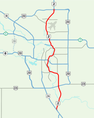
Deerfoot Trail is a 46.4-kilometre (28.8 mi) freeway segment of Highway 2 in Calgary, Alberta, Canada. It stretches the entire length of the city from south to north and links suburbs to downtown via Memorial Drive and 17 Avenue SE. The freeway begins south of Calgary where it splits from Macleod Trail, crosses the Bow River into city limits, and reaches the Stoney Trail ring road. Crisscrossing twice more with the river, it intersects Glenmore Trail and Memorial Drive; the former is a major east–west expressway while the latter is a freeway spur into downtown. In north Calgary, it crosses Highway 1 and passes Calgary International Airport before ending at a second interchange with Stoney Trail. Highway 2 becomes the Queen Elizabeth II Highway as it continues north into Rocky View County towards Edmonton.

Alberta Provincial Highway No. 201, officially named Stoney Trail and Tsuut'ina Trail, is an approximately 92-kilometre (57 mi) freeway in Calgary, Alberta. It forms part of the CANAMEX Corridor which connects Calgary to Edmonton and Interstate 15 in the United States via Highways 2, 3, and 4. Planned for a total length of 101 kilometres, the final segment of the ring road is currently under construction to be completed by 2024 at the latest, delayed from an original target of 2022. The freeway serves as a bypass for the congested routes of 16 Avenue N and Deerfoot Trail through Calgary. At its busiest point near Beddington Trail in north Calgary, the six-lane freeway carried nearly 79,000 vehicles per day in 2019.
Alberta Provincial Highway No. 1A is the designation of two alternate routes off the Alberta portion of Trans-Canada Highway 1. However, it is not the only name used for spurs off Highway 1 - Highway 1X is another such designation. Despite these highways being suffixed routes of Highway 1, they are not part of the Trans-Canada Highway network, and are signed with Alberta's provincial primary highway shields instead of the Trans-Canada shields used for Highway 1.
Parkdale is a mature, inner city neighbourhood in the city of Calgary, Alberta along the north bank of the Bow River between the communities of West Hillhurst and Point McKay. It is bounded on the south by the Bow River, 28 St NW to the east, Shaganappi Trail NW to the west and on the north by 16th Avenue. Parkdale is in close proximity to both the Foothills Medical Centre and the Alberta Children's Hospital constructed in 2006, as well as the University of Calgary. Memorial Drive provides access to downtown Calgary and to Highway 1 which leads to the Rocky Mountains. Parkdale was annexed to the City of Calgary in 1910 when Calgary began to experience a "major economic and building boom." The boom ended in 1913 and further development of the Parkdale Addition as it was called, was halted because of World War I. Following World War II in the 1950s the dominant housing type that characterized Parkdale, was the bungalow. By 2014 Parkdale, like other inner city communities in Calgary, was experiencing gradual gentrification with small cottage-style bungalows being replaced by spacious flat roofed, Prairie School Frank Lloyd Wright inspired infills attracting young families with children away from the long commute suburbs to inner city ease of access to downtown, transit and work.
Crowchild Trail is a major expressway in western Calgary, Alberta. The segment from the 12 Mile Coulee Road at the edge of the city to 16 Avenue NW is designated as Highway 1A by Alberta Transportation. The road is a critical north-south link in West Calgary for both downtown bound traffic and travel between the two quadrants of the city it passes through. Although planned to be one single freeway from Glenmore Trail to the city limits, the route is currently divided by a section of slow moving arterial road with four signalized intersections between 24 Avenue and Memorial Drive. This causes the freeway in the northwest to separated from the freeway south of the Bow River. Filling the gap and making the whole route a minimum six lane freeway is currently planned for construction beyond 2027.
Wildwood is an established neighbourhood in the Southwest quadrant of Calgary, Alberta. It was first settled in 1883 and developed in the 1950s on a plateau to the south to the Bow River valley, and is primarily composed of single-detached bungalows on wide lots with rear laneways.
Shaganappi is a residential neighbourhood in the southwest quadrant of Calgary, Alberta. It is located between 17 Avenue SW and the Bow River. The Shaganappi golf course is located north of the Bow Trail.
Spruce Cliff is a residential neighbourhood in the southwest quadrant of Calgary, Alberta. It is bounded to the north by the CPR tracks and the Bow River, to the east by the Shaganappi golf course and 33 Street W, to the south by Bow Trail and to the west by 37 Street W.

Shaganappi Trail is a major super-4 expressway in the northwest quadrant of Calgary, Alberta. It extends to the south as Montgomery View, a small service road in the neighbourhood of Montgomery and that provides access to Edworthy Park, passes north past Market Mall and the western boundary of Nose Hill Park, and terminates in the neighbourhood of Nolan Hill in the north, with city planning maps indicating future northern extension beyond 144 Avenue NW. The name "Shaganappi" is of Cree origin, referring to the bison hide lacings that held Red River ox carts together. Despite the name, it is not located near the Shaganappi neighbourhood, which is located south of the Bow River.
Sarcee Trail is a major limited-access road in Calgary, Alberta. It is divided into two portions, one in the south end of the city, and one in the north end of the city. Originally planned as one continuous route, plans to connect the two halves have been shelved as it would involve the demolition of homes in Bowness and the disruption of the Bowmont Natural Area park. The urban arterial road is named for the Tsuu T'ina, who were also known as the Sarcee.
The Paskapoo Slopes are a significant natural, environmental and cultural feature on the western side of Calgary, Alberta. They have a high visual impact and are a prominent landmark along the Trans Canada Highway, Calgary's western gateway from the Rockies.

16 Avenue N is a major road in Calgary, Alberta, that forms a 26.5-kilometre (16.5 mi) segment of Highway 1 and connects Calgary to Banff and Medicine Hat. It is a four to six-lane principal arterial expressway at its extremities, but is an urban arterial road between the Bow River and Bowness Road, and also between Crowchild Trail and Deerfoot Trail. Due to Calgary's quadrant system, it is known as 16 Avenue NW west of Centre Street and 16 Avenue NE to the east.

17 Avenue SE is a major arterial road in east Calgary, Alberta. 17 Avenue SE is the focal point of the International Avenue Business Revitalization Zone (BRZ) and the main roadway through the former town of Forest Lawn. Chestermere Boulevard is a major arterial road and the eastern extension of 17 Avenue SE through Chestermere, Alberta, Canada. The roadway is a former alignment of Highway 1A.
The Blue Line, also known as Route 202, is a light rail transit (LRT) line in Calgary, Alberta, Canada. Partnered with the Red Line, and future Green Line it makes up Calgary's CTrain network. Following its initial approval in 1976, the Red Line opened in 1981, with the first trains running on what is now the Blue Line in 1985.

The Red Line, also known as Route 201, is a light rail transit (LRT) line in Calgary, Alberta, Canada. Partnered with the Blue Line, and future Green Line it makes up Calgary's CTrain network. Following its initial approval in 1976, the Red Line opened in 1981, running from Anderson station in the southeast into downtown. The Red Line has gone through a series of expansions, which bring it to its current design. The Red Line services the northwest quadrant and south end of the city beginning at Tuscany station, runs through the downtown core on 7th Avenue, then proceeds southbound where it terminates at Somerset–Bridlewood station. The section of track running along 7th Avenue is shared with the Blue Line. Future expansion of the Red Line includes rerouting the downtown section below 8th Avenue, which would allow the operation of five-car trains, further increasing capacity.

Bowmont Park or Bowmont Natural Environment Park is a 192 hectares urban park on the northern bank of the Bow River in the northwest of the city of Calgary in the communities of Bowness and Montgomery. 'Bowmont' is a combination of their names. The Park was created in the 1980s. The escarpment formed by the Glacial Lake Calgary, runs the length of the park. Both Silver Springs and Varsity communities are perched at the top of the escarpment overlooking the Bow River and are access points to the Park. Bordering the northern banks of the Bow River, the park is includes "grasslands, gullies, valleys, a waterfall with a lookout, off-leash dog-walking areas, hiking, walking and cycling trails, access to the river for swimming and fishing, and more. The most recent expansion of Bowmont Park, Dale Hodges Park which was opened to the public in June 2019, includes innovative public art in the form of sculpted land structures that treat stormwater before it enters the Bow River through the outfall.