
Route 139 is a state highway in Jersey City, New Jersey in the United States that heads east from the Pulaski Skyway over Tonnele Circle to the state line with New Jersey and New York in the Holland Tunnel, which is under the Hudson River, to New York City. The western portion of the route is a two level highway that is charted by the New Jersey Department of Transportation (NJDOT) as two separate roadways: The 1.45-mile (2.33 km) lower roadway (Route 139) between U.S. Route 1/9 (US 1/9) over Tonnele Circle and Interstate 78 (I-78) at Jersey Avenue, and the 0.83-mile (1.34 km) upper roadway running from County Route 501 and ending where it joins the lower highway as part of the 12th Street Viaduct, which ends at Jersey Avenue. The lower roadway is listed on the federal and NJ state registers of historic places since 2005. The eastern 1.32 miles (2.12 km) of the route includes the Holland Tunnel approach that runs concurrent with Interstate 78 on the one-way pair of 12th Street eastbound and 14th Street westbound. Including the concurrency, the total length of Route 139 is 2.77 miles (4.46 km).

Gerrard Street is a street in Toronto, Ontario, Canada. It consists of two separate parts, historically referred to as Lower Gerrard and Upper Gerrard. The former stretches between University Avenue and Coxwell Avenue for 6 km, across Old Toronto. The latter portion starts 300 m north of Lower Gerrard's eastern terminus and runs between Coxwell Avenue and Clonmore Drive, between Victoria Park Avenue and Warden Avenue, in Scarborough for another 4 km.
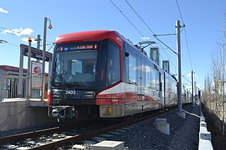
CTrain is a light rail system in Calgary, Alberta, Canada. Much of the system functions as a high-capacity light metro, while in the downtown free-fare zone, trains run like a modern tram with a dedicated right-of-way. This subway-surface alignment is known as semi-metro.

1 Street SW Station is a stop in Downtown Calgary on the city's C-Train light rail system. The 1 Street platform is served by westbound trains only, with the nearest eastbound train platforms being Centre Street station and 3 Street SW station, both of which only serve eastbound trains. The platform is located on the north side of 7 Avenue South, west of Centre Street within the free fare zone, serving both routes 201 and 202.

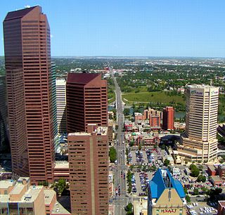
Downtown Calgary is a dense urban district in central Calgary, Alberta. It contains the second largest concentration of head offices in Canada, despite only being the country's fourth largest city in terms of population. The downtown is divided into several residential, commercial, corporate, and mixed-use neighbourhoods, including the Financial District (CBD), Eau Claire, Chinatown, East Village, Beltline, and the West End.
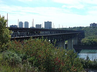
The High Level Bridge is a bridge that spans the North Saskatchewan River in Edmonton, Alberta, Canada.

Poquessing Creek is a 10.3-mile-long (16.6 km) creek, a right tributary of the Delaware River, that forms the boundary between Philadelphia and Bensalem Township, which borders it to the northeast along the Delaware. It has defined this boundary between Bucks and Philadelphia counties since 1682.

The Bow is a 158,000-square-metre (1,700,000 sq ft) skyscraper in downtown Calgary, Alberta, Canada. The 236 metre (774 ft) building was the tallest in Calgary between July 8, 2010, when it surpassed the Suncor Energy Centre, and May 11, 2016, when it was exceeded by Brookfield Place. The Bow is currently the second tallest office tower in Calgary and the third tallest in Canada outside Toronto. The Bow is also considered the start of redevelopment in Calgary's Downtown East Village. It was completed in 2012 and was ranked among the top 10 architectural projects in the world of that year according to Azure magazine. It was built for oil and gas company Encana, and was the headquarters of its successors Ovintiv and Cenovus.

Sunnyside is an innercity community in Calgary, Alberta located on the north side of the Bow River immediately adjacent to Calgary's downtown. The community partners with the neighbouring community of Hillhurst to form the Hillhurst-Sunnyside Community Association. The combined communities have an area redevelopment plan in place, revised in 2009.
Centre Street is a major road in Calgary, Alberta, and defines the east and west halves of the city for the purposes of street addresses.
Line 6 Finch West, also known as the Finch West LRT, is a light rail line under construction in Toronto, Ontario, Canada, to be operated by the Toronto Transit Commission. The 10.3-kilometre (6.4 mi), 18-stop line is to extend from Finch West station on Line 1 Yonge–University to the North Campus of Humber College in Etobicoke. The line will operate in a dedicated above-ground right-of-way, much of it within Finch Avenue, segregated from street traffic. The line will use transit signal priority and standard gauge rather than the broad Toronto gauge. The line is forecast to carry about 14.6 million rides a year or 40,000 a day by 2031 and will replace the 36B Finch West bus route, which is one of the three busiest bus routes in Toronto. Line 6 was expected to open within the first half of 2024, with an estimated cost of CA$2.5 billion. For budget purposes, the TTC made the assumption that Line 6 would open no earlier than September 2024. However, the builder, Mosaic Transit Group, expects the line to open by the end of 2024.

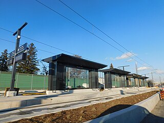
Shaganappi Point station is a CTrain light rail station in Shaganappi, Calgary, Alberta, Canada. It is located in the median of Bow Trail, just west of 26th St. SW, 3km West of the 7 Avenue & 9 Street SW Interlocking. The second station on the West line, it opened with preview service on December 8, 2012, and opened for revenue service on December 10, 2012.

Peace Bridge is a bridge that accommodates people walking and cycling across the Bow River in Calgary, Alberta, Canada. The bridge, designed by Spanish architect Santiago Calatrava, opened for use on March 24, 2012.

Centre Street station is a stop in downtown Calgary on the city's CTrain light rail system. It is only used by eastbound trains, with the nearest stations serving westbound trains being 1 Street Southwest station and City Hall/Bow Valley College, serving both directions. The platform is located on the south side of 7 Avenue South, east of Centre Street, and is located inside the free fare zone serving both routes 201 and 202.

The Hurontario LRT is a light rail line under construction in the cities of Mississauga and Brampton, Ontario, Canada. The line will run along Hurontario Street from Mississauga's Port Credit neighbourhood north to Steeles Avenue in Brampton. The line will be built and operated as a public-private partnership by Mobilinx, a consortium of private European and Japanese companies, with provincial transit agency Metrolinx retaining ownership of the line. It will be the only street railway operating in the Greater Toronto Area outside Toronto proper.

Mount Dennis is an intermodal transit terminal under construction in Toronto, Ontario, Canada. Located east of the intersection of Eglinton Avenue and Weston Road in the Mount Dennis neighbourhood in the district of York, the station will be the western terminus of the future Line 5 Eglinton as well as an intermediate station on the GO Transit Kitchener line and Union Pearson Express. The station has been designated as one of many "mobility hubs" in Greater Toronto. It is scheduled to open in 2024.
The Blue Line, also known as Route 202, is a light rail transit (LRT) line in Calgary, Alberta, Canada. Partnered with the Red Line, and future Green Line it makes up Calgary's CTrain network. Following its initial approval in 1976, the Red Line opened in 1981, with the first trains running on what is now the Blue Line in 1985.
The Green Line, also known as Route 203 is a light rail (LRT) line under construction in Calgary, Alberta, Canada. The line will run between Calgary's north-central and southeastern boundaries, connecting with the Red Line and Blue Line in the city's downtown. The Green Line is the largest public infrastructure project in Calgary's history and will be the first rail line in the city to operate low-floor trains. When completed, the Green Line will comprise 29 stations spanning 46 kilometres (29 mi). This will bring the total number of CTrain stations in Calgary to 74.
Airport Trail and 96 Avenue NE is an arterial road and developing expressway in the northeast quadrant of Calgary, Alberta. It is an important east-west roadway and is the main access route to the Calgary International Airport.


