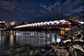
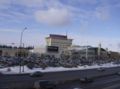
List of tourist attractions in Calgary

Last updated

This is a list of tourist attractions in Calgary, Alberta, Canada.

Contents

The city of Calgary has over one million inhabitants. Tourism is an important part of the local economy, contributing $2.1 billion dollars in 2019. [1]

Downtown

AttractionAddressTypeRemarksImage
Arts Commons 205 8 Avenue S.E
51°02′43″N114°03′37″W / 51.04528°N 114.06028°W / 51.04528; -114.06028 (EPCOR Centre)
Arts venuePerforming arts venue, home of Calgary Philharmonic Orchestra
EPCOR Centre Epcor Centre 3.jpg
EPCOR Centre
Burns Building 237 8 Ave SE
51°02′45″N114°03′31″W / 51.04583°N 114.05861°W / 51.04583; -114.05861 (Calgary Burns Building)
BuildingHistoric site built by Pat Burns in 1913
Burns Building Burns Building 2.jpg
Burns Building
Calgary Telus Convention Centre 120 9 Ave SE
51°02′43″N114°03′39″W / 51.04528°N 114.06083°W / 51.04528; -114.06083 (Telus Convention Centre)
Convention centre
Telus Convention Centre Glenbow Museum 3.jpg
Telus Convention Centre
Calgary Tower 101 9 Ave SW
51°02′40.0″N114°03′48.7″W / 51.044444°N 114.063528°W / 51.044444; -114.063528 (Calgary Tower)
Tower Observation tower
Calgary Tower Calgarytower.jpg
Calgary Tower
Chinese Cultural Centre 197 1 St SW
51°03′06″N114°03′56″W / 51.05167°N 114.06556°W / 51.05167; -114.06556 (Chinese Cultural Centre)
Museum
Chinese Cultural Centre Chinatown, Calgary.jpg
Chinese Cultural Centre
City Hall 800 Macleod Trail SE
51°02′42″N114°03′26″W / 51.04500°N 114.05722°W / 51.04500; -114.05722 (City Hall)
BuildingNational Historic Site
City Hall Calgary city hall1.jpg
City Hall
Devonian Gardens 409 8 Ave SW
51°02′45.6″N114°04′23.4″W / 51.046000°N 114.073167°W / 51.046000; -114.073167 (Devonian Gardens)
Urban park Botanical garden with seasonal exhibitions
Devonian Gardens DevonianGardens-11.jpg
Devonian Gardens
Dragon City Mall 100 3 Ave SE
51°03′02.2″N114°03′43.6″W / 51.050611°N 114.062111°W / 51.050611; -114.062111 (Dragon City Mall)
Shopping mall Asian-themed mall
Dragon City Mall Dragon city Mall-Calgary.JPG
Dragon City Mall
Fairmont Palliser Hotel 133 9 Ave SW
51°02′40″N114°03′55″W / 51.04444°N 114.06528°W / 51.04444; -114.06528 (Fairmont Palliser)
Hotel One of Canada's grand railway hotels
Fairmont Palliser Fairmont Palliser Hotel 1.jpg
Fairmont Palliser
Fort Calgary 750 9 Ave SE
51°02′42.5″N114°02′44.8″W / 51.045139°N 114.045778°W / 51.045139; -114.045778 (Fort Calgary)
Museum National Historic Site
Fort Calgary Fort Calgary Residence 2.jpg
Fort Calgary
Glenbow Museum 130 9 Ave SE
51°02′41″N114°03′39″W / 51.04472°N 114.06083°W / 51.04472; -114.06083 (Glenbow Museum)
Museum Western Canada's largest museum
Glenbow Museum Glenbow Museum 1.jpg
Glenbow Museum
Shaw Millennium Park 800 11 St SW
51°02′46″N114°05′30″W / 51.04611°N 114.09167°W / 51.04611; -114.09167 (Millennium Park)
Urban park Skatepark
Millennium Park Millennium-Park3-Szmurlo.jpg
Millennium Park
National Music Centre 134 11 Ave SE
51°02′33″N114°03′39″W / 51.04250°N 114.06083°W / 51.04250; -114.06083 (Cantos Foundation)
Museum Over 2,000 rare instruments and artifacts along with the Canadian Music Hall of Fame and Canadian Country Music Hall of Fame collections
National Music Centre Studio Bell home of the National Music Center (43870574572).jpg
National Music Centre
Olympic Plaza 801 Macleod Trail SE
51°02′45″N114°03′31″W / 51.04583°N 114.05861°W / 51.04583; -114.05861 (Olympic Plaza)
Urban park Named for the 1988 Winter Olympics, site of open-air festivals
Olympic Plaza Olympic Plaza Calgary.jpg
Olympic Plaza
Peace Bridge 51°03′14″N114°04′44″W / 51.05389°N 114.07883°W / 51.05389; -114.07883 (Peace Bridge) BridgeOne of the most photographed sites in Calgary
Peace Bridge The Peace Bridge in Calgary an HDR photo.jpg
Peace Bridge
Plus 15 Downtown Calgary Skyway Skywalk network
+15 Plus15-Calgary-7ave.JPG
+15
Prince's Island Park 100 2 St SW
51°03′18″N114°04′03″W / 51.05500°N 114.06750°W / 51.05500; -114.06750 (Prince's Island)
Urban park Hosts open-air festivals
Prince's Island Park Prince'sIsland.jpg
Prince's Island Park
Stephen Avenue 8 Ave SW
51°02′44″N114°03′56″W / 51.04556°N 114.06556°W / 51.04556; -114.06556 (Stephen Ave)
Street Heritage buildings
Stephen Avenue Stephen-Ave-Historic-Szmurlo.jpg
Stephen Avenue
The Bow 124 7th Ave SE
51°02′52″N114°03′44″W / 51.04778°N 114.06222°W / 51.04778; -114.06222 (The Bow)
Skyscraper Second-tallest building in Calgary
The Bow The Bow in Calgary.jpg
The Bow
West Eau Claire Park Bow River Pathway
Urban park Redevelopment adjacent to the Peace Bridge
West Eau Clair Park West Eau Clair Park.jpg
West Eau Clair Park

Northwest

AttractionAddressTypeRemarksImage
Confederation Park 24 Ave & 14 St NW
51°04′36″N114°05′04″W / 51.07667°N 114.08444°W / 51.07667; -114.08444 (Confederation Park)
Urban park Site of Lions Club Christmas Light Display
Confederation Park Confederation-Park-Szmurlo.jpg
Confederation Park
Foothills Stadium 2825 24 Ave NW
51°4′24.37″N114°7′14.29″W / 51.0734361°N 114.1206361°W / 51.0734361; -114.1206361 (Foothills Stadium)
Sports venue Baseball stadium
Foothills Stadium Foothills Stadium 5.jpg
Foothills Stadium
Kensington Kensington Rd NW
51°03′09″N114°05′41″W / 51.05250°N 114.09472°W / 51.05250; -114.09472 (Kensington)
Street Business Revitalisation Zone, shopping and restaurants, heritage buildings
Kensington Kensignton Wine Market 4.jpg
Kensington
Market Mall 3625 Shaganappi Trail NW
51°05′05″N114°09′22″W / 51.08472°N 114.15611°W / 51.08472; -114.15611 (Market Mall)
Shopping mall One of the largest malls (by area) in Calgary
Market Mall Market Mall 12.jpg
Market Mall
Parkdale Parkdale Boulevard
51°03′32″N114°08′19″W / 51.05889°N 114.13861°W / 51.05889; -114.13861 (Parkdale)
Public art Parkdale Plaza
"Outfall" Outfall by Brian Tolle looking east 02.JPG
"Outfall"
McMahon Stadium 1817 Crowchild Trail NW
51°4′13″N114°7′17″W / 51.07028°N 114.12139°W / 51.07028; -114.12139 (McMahon Stadium)
Sports venue Canadian football stadium, home of the Calgary Stampeders (CFL)
McMahon Stadium McMahon Stadium 6.jpg
McMahon Stadium
Baker Park 1817 Crowchild Trail NW
51°05′50″N114°12′56″W / 51.09722°N 114.21556°W / 51.09722; -114.21556 (Baker Park)
Urban park Most popular Calgary park for outdoor wedding. River observation point.
Nose Hill Park 14 St, Shaganappi Trail, John Laurie Blvd NW
51°07′N114°07′W / 51.117°N 114.117°W / 51.117; -114.117 (Nose Hill Park)
Urban park One of the largest municipal parks in Canada
Nose Hill Park Nose Hill +downtown.JPG
Nose Hill Park
Olympic Oval 111 University Gate NW
51°04′37″N114°08′08″W / 51.07694°N 114.13556°W / 51.07694; -114.13556 (Olympic Oval)
Sports venue Speed skating oval, home of the Calgary Inferno CWHL hockey team
Olympic Oval Olympic Oval Panorama1.jpg
Olympic Oval
Southern Alberta Jubilee Auditorium 1415 14 Ave NW
51°03′45″N114°05′35″W / 51.06250°N 114.09306°W / 51.06250; -114.09306 (Jubilee Auditorium)
Music venue Performing arts, culture and community facility, home of Calgary Opera
Southern Alberta Jubilee Auditorium Alberta Jubilee Auditorium 2.jpg
Southern Alberta Jubilee Auditorium
University of Calgary 2500 University Dr NW
51°04′39″N114°07′59″W / 51.07750°N 114.13306°W / 51.07750; -114.13306 (U of C)
University Public university
University of Calgary UofC-Aerial.JPG
University of Calgary

Northeast

AddressTypeRemarksImage
Baitun Nur 4353 54 Avenue NE
51°06′06″N113°58′19″W / 51.101743°N 113.972039°W / 51.101743; -113.972039 (Baitun Nur)
Mosque Largest mosque in Canada
Baitun Nur mosque Ahmadiyya Mosque 05a.jpg
Baitun Nur mosque
The Hangar Flight Museum 4629 McCall Way NE
51°05′39″N114°00′47″W / 51.09417°N 114.01306°W / 51.09417; -114.01306 (Aerospace Museum)
Museum History of aviation and space technology of western Canada
Aero Space Museum of Calgary, October 2011.jpg
YYC Calgary International Airport 2000 Airport Rd NE
51°06′50″N114°01′13″W / 51.11389°N 114.02028°W / 51.11389; -114.02028 (Calgary Airport)
Airport International airport, part of the National Airports System
Calgary International Airport Calgary Airport overview.jpg
Calgary International Airport
Marlborough Mall 433 Marlborough Way NE
51°03′17″N113°58′42″W / 51.05472°N 113.97833°W / 51.05472; -113.97833 (Marlborough Mall)
Shopping mall Opened in 1972
Marlborough Mall Marlborough Mall 2.jpg
Marlborough Mall
Sunridge Mall 2525 36 St NE
51°04′28″N113°59′09″W / 51.07444°N 113.98583°W / 51.07444; -113.98583 (Sunridge Mall)
Shopping mall Opened in 1981
Sunridge Mall Sunridge Mall 3.jpg
Sunridge Mall
Telus Spark 220 St. George's Drive NE
51°02′52″N114°05′19″W / 51.04778°N 114.08861°W / 51.04778; -114.08861 (Telus Spark)
Museum Interactive exhibits, multimedia presentations, educational demonstrations
Telus World of Science TELUS World of Science, Calgary 4.jpg
Telus World of Science
Wilder Institute/Calgary Zoo 1300 Zoo Rd NE
51°02′45″N114°02′00″W / 51.04583°N 114.03333°W / 51.04583; -114.03333 (Calgary Zoo)
Zoo Second largest zoo in Canada
Calgary Zoo CalgaryzooRain.JPG
Calgary Zoo

Southwest

AddressTypeRemarksImage
Battalion Park Signal Hill Ctr SW
51°01′13″N114°10′17″W / 51.02028°N 114.17139°W / 51.02028; -114.17139 (Battalion Park)
Urban park Formerly known as Camp Sarcee
Battalion Park Battalion-Park-Szmurlo.jpg
Battalion Park
Canada Olympic Park 88 Canada Olympic Rd NW
51°04′47″N114°11′57″W / 51.07972°N 114.19917°W / 51.07972; -114.19917 (Canada Olympic Park)
Ski resort 1988 Winter Olympics venue now used for Recreation and Athletic training
Canada Olympic Park Canada olympic park summer 2005.jpeg
Canada Olympic Park
Canada's Sports Hall of Fame 169 Canada Olympic Road NW
51°04′57″N114°13′16″W / 51.08250°N 114.22111°W / 51.08250; -114.22111 (Canada's Sports Hall of Fame)
Museum The main national hall of fame for sports in general
Hall of Fame Hall of Fame Facade.jpg
Hall of Fame
Chinook Centre 6455 Macleod Trail SW
50°59′54″N114°04′26″W / 50.99833°N 114.07389°W / 50.99833; -114.07389 (Chinook Centre)
Shopping mall Opened in 1960
Chinook Centre Chinook Centre 2.jpg
Chinook Centre
Edworthy Park Edworthy St SW
51°03′41″N114°09′23″W / 51.06139°N 114.15639°W / 51.06139; -114.15639 (Edworthy Park)
Urban park Located along the Bow River
Edworthy Park Calgary-Edworthy Park.JPG
Edworthy Park
Fish Creek Park SW Calgary
50°55′40″N114°07′42″W / 50.92778°N 114.12833°W / 50.92778; -114.12833 (Fish Creek)
Provincial park One of the largest urban parks in North America
Fish Creek Provincial Park Fish-Creek-Park-Szmurlo.jpg
Fish Creek Provincial Park
Glenmore Reservoir 14th St & Glenmore Trail SW
50°58′53″N114°06′50″W / 50.98139°N 114.11389°W / 50.98139; -114.11389 (Glenmore Reservoir)
Lake Manmade reservoir on the Elbow River
Glenmore Reservoir Calgary downtown from glenmore reservoir.JPG
Glenmore Reservoir
Heritage Park Heritage Dr & 14th St SW
50°59′07″N114°06′30″W / 50.98528°N 114.10833°W / 50.98528; -114.10833 (Heritage Park)
Museum Historical Village
Heritage Park Historical Village Mainstreet-Heritage park.jpg
Heritage Park Historical Village
Marda Loop 33rd Avenue SW
51°01′26″N114°06′47″W / 51.02389°N 114.11306°W / 51.02389; -114.11306 (Marda Loop)
Street Shopping, Business Revitalization Zone
Marda Loop Marda Loop Square 1.jpg
Marda Loop
Spruce Meadows Spruce Meadows Way SW
50°53′06″N114°06′02″W / 50.88500°N 114.10056°W / 50.88500; -114.10056 (Spruce Meadows)
Venue Equestrian facility
Spruce Meadows Spruce-Meadows-Szmurlo.jpg
Spruce Meadows
MNP Community & Sport Centre 2225 Macleod Trail SW
51°02′04″N114°03′48″W / 51.03444°N 114.06333°W / 51.03444; -114.06333 (Talisman Centre)
VenueMulti-sports complex
Talisman Centre Talisman Centre 6.jpg
Talisman Centre
The Military Museums 1820 - 24 Street SW
4520 Crowchild Trail SW
51°00′52″N114°06′57″W / 51.01444°N 114.11583°W / 51.01444; -114.11583 (Military Museums)
Museum Comprises the Naval Museum of Alberta, the Air Force Museum of Alberta, Library and Archives
The Military Museums Military-Museums-Szmurlo.jpg
The Military Museums
17th Avenue 17 Ave SW
51°02′16″N114°04′54″W / 51.03778°N 114.08167°W / 51.03778; -114.08167 (17th Avenue)
Street Shopping and entertainment, site of Red Mile

Southeast

AddressTypeRemarksImage
Stampede Grounds 1410 Olympic Way SE
51°02′01″N114°03′14″W / 51.03361°N 114.05389°W / 51.03361; -114.05389 (Stampede)
VenueFair and Exhibition grounds
Calgary Stampede StampedeRodeo2002.JPG
Calgary Stampede
Fish Creek Provincial Park South Calgary
50°54′12″N114°01′11″W / 50.90333°N 114.01972°W / 50.90333; -114.01972 (Fish Creek Park)
Provincial park One of the largest urban parks in North America
Fish Creek Provincial Park Fish Creek Provincial Park Beaver Lodge.JPG
Fish Creek Provincial Park
Inglewood 9 Ave SE
51°02′34″N114°02′22″W / 51.04278°N 114.03944°W / 51.04278; -114.03944 (Inglewood)
Street Heritage buildings [2]
Inglewood Inglewood-2004.JPG
Inglewood
International Avenue 17 Ave SE ( Highway 1A )
51°02′16″N113°58′54″W / 51.03778°N 113.98167°W / 51.03778; -113.98167 (International Ave)
Street Business Revitalization Zone, [3] cultural diverse neighbourhood, site of GlobalFest
International Avenue International Avenue 6.jpg
International Avenue
Max Bell Centre 1001 Barlow Trail SE
51°02′32″N114°00′13″W / 51.04222°N 114.00361°W / 51.04222; -114.00361 (Max Bell Centre)
Sports venue Ice hockey arena
Max Bell Centre Max Bell Centre 1.jpg
Max Bell Centre
Scotiabank Saddledome 555 Saddledome Rise SE
51°02′15″N114°03′07″W / 51.03750°N 114.05194°W / 51.03750; -114.05194 (Saddledome)
Venue Ice hockey arena, home of the Calgary Flames (NHL), performing arts
Scotiabank Saddledome Calgary Skyline with Saddledome 2015.jpg
Scotiabank Saddledome
Sikome Lake Bow Bottom Trail SE
50°53′58″N114°00′56″W / 50.89944°N 114.01556°W / 50.89944; -114.01556 (Sikome Lake)
LakeMan-made lake, public beach
Sikome Lake Sikome lake-2002.JPG
Sikome Lake
Southcentre Mall 100 Anderson Rd SE
50°56′30″N114°04′05″W / 50.94167°N 114.06806°W / 50.94167; -114.06806 (Southcentre Mall)
Shopping mall Opened in 1974
Southcentre Mall Southcentre Mall 5.jpg
Southcentre Mall

See also

Related Research Articles

<span class="mw-page-title-main">Highwood River</span> River in Alberta, Canada

The Highwood River is a tributary of the Bow River in southwestern Alberta, Canada.

<span class="mw-page-title-main">Tiverton, Nova Scotia</span> Village in Nova Scotia, Canada

Tiverton is a small village located on the northeast tip of Long Island, Nova Scotia. Tiverton has a population of about 300 people. It was named for Tiverton, Devon.

<span class="mw-page-title-main">Alberta Highway 663</span>

Alberta Provincial Highway No. 663 is a highway in the province of Alberta, Canada. It runs west-east from Highway 44 near Fawcett, runs concurrent with Highway 2 and Highway 63 to Boyle. Then to a concurrency with Highway 55 in Lac La Biche before extending north around Lakeland Provincial Park to Torchwood Lake. It is also known as Taylor Road in Boyle, and 88 Avenue in Lac La Biche.

<span class="mw-page-title-main">Bow River pathway</span>

The Bow River pathway is a pathway system developed along the banks of the Bow River in the city of Calgary. It contains a network of pedestrian and bicycle paths connecting parks on both sides of the river.

Stoney Nakoda First Nation is a Nakoda First Nations band government Alberta, Canada. It is located West of Calgary, in the foot of the Rocky Mountains.

References

  1. "Business Plan" (PDF). Visit Calgary. Tourism Calgary. Retrieved 28 September 2023.
  2. Inglewood Main Street Archived 2007-02-27 at the Wayback Machine - Alberta Heritage
  3. Business Revitalization Zone - International Avenue