List of bridges in Calgary

Last updated

Bridges span the two rivers that cross Calgary: Bow River and Elbow River Calgary street map.png
Bridges span the two rivers that cross Calgary: Bow River and Elbow River

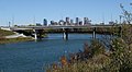
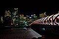
The City of Calgary has a number of bridges, spanning the two main rivers that cross the city, Bow River and Elbow River, as well as some other geographical and physical features.

Contents

The first building in Calgary was erected in 1872 by Alexis Cardinal, at the request of Fr Constantine Scollen, an Oblate missionary priest, at the confluence of the two rivers.

Crossings

Bow River (west of downtown)

The Bow River enters the city from west, winds around downtown, then runs south. From west to south, the following structures cross the river.

BridgeCarriesLengthBuiltCoordinatesImageRemarks
Bearspaw DamUtility1954 51°06′04″N114°16′57″W / 51.10124°N 114.28251°W / 51.10124; -114.28251 (Bearspaw Dam) Dam on Calgary's west limits, east of Bearspaw; built in 1954, [1] owned and maintained by TransAlta
Stoney Trail Bow River Bridges Stoney Trail 476 m1997/2023 51°05′53″N114°13′56″W / 51.09798°N 114.23219°W / 51.09798; -114.23219 (Stoney Trail bridge) Stoney Bow Bridge.JPG Between Trans Canada Highway and Tuscany; The northbound bridges lower pedestrian deck connects to the south and north Bow River pathways
85 St NW Bridge85 Street NW 51°05′53″N114°12′38″W / 51.09794°N 114.21052°W / 51.09794; -114.21052 (85 Street SW bridge) Bow river x 85 StNW.JPG Between Bowness and Scenic Acres
Bowness Pedestrian BridgePathway 51°05′52″N114°12′05″W / 51.09785°N 114.20138°W / 51.09785; -114.20138 (Bowness pedestrian bridge) Bowness, Railway and Bow.JPG Connects Bow River pathways between Bowmont Park Natural Area and Bowness
Bowness Railway Bridge Canadian Pacific Railway 51°05′53″N114°12′00″W / 51.09797°N 114.20002°W / 51.09797; -114.20002 (Bowness CPR bridge) Bowness, Railway and Bow.JPG
John Hextall BridgePedestrian/Cycle1910 [2] 51°04′43″N114°10′20″W / 51.07869°N 114.17229°W / 51.07869; -114.17229 (John Hextall Bridge) Bowness, Bow River, Bowness Rd, Highway 1.JPG Between Bowness and Montgomery; parallels Shouldice Bridge and is used for pedestrian and bicycle traffic only; originally carried a streetcar.
Shouldice BridgeBowness Road NW 51°04′43″N114°10′20″W / 51.07863°N 114.17236°W / 51.07863; -114.17236 (Bowness Road bridge) Bowness, Bow River, Bowness Rd, Highway 1.JPG Between Bowness, Shouldice Park and Montgomery
TCH Bridge 16 Avenue NW 51°04′38″N114°10′39″W / 51.07722°N 114.17745°W / 51.07722; -114.17745 (Trans-Canada highway bridge) TC1-Bow Bridge Calgary.JPG Between Sarcee Trail and Montgomery
Harry Boothman BridgePedestrian 51°03′53″N114°09′16″W / 51.06464°N 114.15453°W / 51.06464; -114.15453 (Edworthy Park bridge) Edworthy Park Bridge.JPG Pedestrian alley in Edworthy Park, between the Bow River pathways; named for Harry Boothman. superintendent and director of Calgary Parks from 1958 to 1976
Crowchild Trail Bridge Crowchild Trail 51°02′49″N114°06′54″W / 51.04686°N 114.11494°W / 51.04686; -114.11494 (Crowchild Trail bridge)
Crowchild Trail Bow River Calgary 2.jpg
Crowchild Trail
Between Shaganappi and Kensington, lower pedestrian deck connects pathways on each side of the river
Mewata Bridge 14 Street W 1954 [2] 51°02′53″N114°05′41″W / 51.04801°N 114.09471°W / 51.04801; -114.09471 (Mewata Bridge) 14St SW Bridge.jpg Between Kensington and Sunalta

Bow River (downtown)

BridgeCarriesLengthBuiltCoordinatesImageRemarks
Louise bridge 10 Street SW172 m1921 51°03′04″N114°05′06″W / 51.05116°N 114.08490°W / 51.05116; -114.08490 (Louise Bridge) Calgary West End.jpg Connects Downtown West End with Memorial Drive and Kensington; named after Louise Cushing, daughter of William Henry Cushing, Calgary mayor from 1900 to 1901 [3]
Sunnyside C-Train Bridge C-Train Route 201 and pedestrian (lower deck)1987 51°03′07″N114°05′00″W / 51.05184°N 114.08337°W / 51.05184; -114.08337 (Sunnyside C-Train bridge) C-Train bridge-lower deck.JPG Between Sunnyside and 8 Street SW stations; lower deck is a pedestrian walkway
Peace Bridge Pedestrian and bicycle125 m2012 51°03′14″N114°04′45″W / 51.05375°N 114.07913°W / 51.05375; -114.07913 (Peace Bridge) Peace Bridge Calgary.jpg between Downtown and Sunnyside
Prince's Island CausewayPedestrian and service road 51°03′13″N114°04′35″W / 51.05367°N 114.07643°W / 51.05367; -114.07643 (Prince's Island Causeway) Prince's Island Causeway.jpg Connects Eau Claire Park pathway with west part of Prince's Island Park, provides access to Enmax stage
Prince's Island Bridge Pedestrian 51°03′25″N114°04′09″W / 51.05704°N 114.06919°W / 51.05704; -114.06919 (Prince's Island Bridge) Princes Island Bridge1.JPG Connects Prince's Island Park with Sunnyside, also crosses Memorial Drive
Jaipur Bridge Pedestrian 51°03′16″N114°04′11″W / 51.05432°N 114.06959°W / 51.05432; -114.06959 (Jaipur Bridge) Jaipur bridge.JPG Connects Prince's Island Park with Eau Claire
Prince's Island Bridge East EndPedestrian pathway 51°03′15″N114°04′03″W / 51.05424°N 114.06742°W / 51.05424; -114.06742 (East Princes Island Bridge) Ped Bridge PIP.JPG Connects eastern Prince's Island Park with Eau Claire and Chinatown
Centre Street Bridge Centre Street 178 m1916 51°03′10″N114°03′45″W / 51.05291°N 114.06255°W / 51.05291; -114.06255 (Centre Street Bridge)
Centre Street Bridge Centre-Street-Bridge-Szmurlo.jpg
Centre Street Bridge
Connects Downtown Calgary to Crescent Heights; lower deck connects Chinatown to Memorial Drive
4th Avenue Flyover4th Avenue SE1972 51°03′01″N114°03′10″W / 51.05014°N 114.05265°W / 51.05014; -114.05265 (4th Avenue Flyover)
4th Avenue Flyover 4 ave flyover calgary.JPG
4th Avenue Flyover
Connects Memorial Drive to Downtown Calgary
5th Avenue Flyover5th Avenue SE 51°02′58″N114°03′04″W / 51.04937°N 114.05098°W / 51.04937; -114.05098 (5 Avenue SE flyover)
4th Avenue Flyover, Langevin Bridge and C-Train Bridge Calgary - Calgary Tower - Northeast 01 new.JPG
4th Avenue Flyover, Langevin Bridge and C-Train Bridge
Connects Downtown Calgary to Memorial Drive, Crescent Heights and Bridgeland.
Reconciliation Bridge Edmonton Trail 1910 51°03′00″N114°03′08″W / 51.04992°N 114.05230°W / 51.04992; -114.05230 (Langevin Bridge)
Langevin Bridge Reconciliation Bridge-Calgary.jpg
Langevin Bridge
Connects Bridgeland to Downtown Calgary; south terminus of Edmonton Trail. Formerly called the Langevin Bridge (1910-2017), named for Sir Hector Langevin [4]
C-Train SE/Bridgeland Bridge C-Train Route 2021985 51°02′57″N114°03′01″W / 51.04928°N 114.05027°W / 51.04928; -114.05027 (C-Train SE/Bridgeland bridge)
4th Avenue Flyover, Langevin Bridge and C-Train Bridge Calgary - Calgary Tower - Northeast 01 new.JPG
4th Avenue Flyover, Langevin Bridge and C-Train Bridge
Between 3 Street SE and Bridgeland/Memorial stations
George C. King Bridge (formerly St. Patrick's Island Bridge) Bow River pathways 2014 51°02′50″N114°02′47″W / 51.04731°N 114.04629°W / 51.04731; -114.04629 (St. Patrick's Island Bridge) Connects Downtown East Village, Fort Calgary and Bow River pathways with St Patrick Island and Calgary Zoo; new project to cross to Bridgeland [5]
Baines BridgeZoo Road 51°02′50″N114°02′10″W / 51.04724°N 114.03624°W / 51.04724; -114.03624 (Baines Bridge)
View from St George Drive Bridge Memorial-Drive1-Szmurlo.jpg
View from St George Drive Bridge
Connects Calgary Zoo and Bridgeland
Zoo Bridge (W) Calgary Zoo pathway 51°02′48″N114°01′51″W / 51.04654°N 114.03090°W / 51.04654; -114.03090 (Calgary Zoo West bridge) Connects main Calgary Zoo exhibits with the Prehistoric Park
Zoo Bridge (E) Calgary Zoo pathway 51°02′45″N114°01′41″W / 51.04578°N 114.02798°W / 51.04578; -114.02798 (Calgary Zoo East bridge)
Zoo Bridge East Zoo Bridge East.JPG
Zoo Bridge East
Connects main Calgary Zoo exhibits with the Canadian Wilds
St. Georges Zoo Bridge12 Street SE 51°02′36″N114°01′56″W / 51.04339°N 114.03219°W / 51.04339; -114.03219 (St. Georges Zoo Bridge) St George Zoo Bridge.JPG Connects Calgary Zoo with Inglewood
Canadian Pacific Bridge (Nose Creek) Canadian Pacific Railway 51°02′40″N114°01′08″W / 51.04440°N 114.01879°W / 51.04440; -114.01879 (Canadian Pacific Bridge (Nose Creek))
Canadian Pacific Railway Bridge in background Bow with Zoo.JPG
Canadian Pacific Railway Bridge in background
Railroad bridge

Bow River (south of downtown)

BridgeCarriesLengthBuiltCoordinatesImageRemarks
Cushing Bridge Blackfoot Trail SE / 17 Avenue SE 51°02′14″N114°00′46″W / 51.03736°N 114.01280°W / 51.03736; -114.01280 (Cushing bridge Blackfoot Trail SE) Connects Inglewood with Forest Lawn; named after William Henry Cushing, Calgary mayor from 1900 to 1901 [3]
CPR Bonnybrook Bridge Canadian Pacific Railway 51°00′51″N114°00′44″W / 51.014254°N 114.012294°W / 51.014254; -114.012294 (Canadian Pacific Bonnybrook Bridge) Pony truss railroad bridge, connects three main tracks (P-1 mainline, P-2 lead and Old Ogden lead) with CPR Alyth Yard. The bridge is partially collapsed after flooding of Bow River in June 2013. [6] Steel bridge added in 1971.

and Old Ogden lead,

CNR Bow River Bridge Canadian National Railway 51°00′52″N114°00′41″W / 51.014403°N 114.011521°W / 51.014403; -114.011521 (Canadian National Bridge Bow River) Through truss bridge has a single track.
Bonnybrook Bridge Ogden Road SE 51°00′46″N114°00′46″W / 51.01290°N 114.01284°W / 51.01290; -114.01284 (Bonnybrook Bridge (Ogden Road)) Vehicular bridge carries Ogden Road and connects Alyth with Foothills Industrial Park
Calf Robe Bridge Deerfoot Trail 51°00′31″N114°01′07″W / 51.00856°N 114.01869°W / 51.00856; -114.01869 (Calf Robe Bridge) Connects Deerfoot trail from Glenmore Trail to Peigan Road; named after Ben Calf Robe, a Siksika chief
Canadian National Bridge CN Railway 51°00′16″N114°01′19″W / 51.00437°N 114.02195°W / 51.00437; -114.02195 (Canadian National Bridge) Connects Canadian Pacific Railway to Canadian National Railway
Graves Bridges Glenmore Trail 50°59′12″N114°01′29″W / 50.98658°N 114.02466°W / 50.98658; -114.02466 (Glenmore Trail Graves Bridge) Connects Alyth to Riverbend and Ogden, leads to Highway 8 east; twinned in 2009 [7]
Sue Higgins BridgePedestrian 50°58′10″N114°01′33″W / 50.96957°N 114.02575°W / 50.96957; -114.02575 (Southland Pedestrian Bridge) Connects Southland Drive and Acadia to Riverbend
Lafarge BridgeRoad 50°57′23″N114°01′23″W / 50.95651°N 114.02295°W / 50.95651; -114.02295 (Lafarge Bridge) Connects Lafarge cement plant to Douglasglen. Damaged in 2005 flood, subsequently removed.
Ivor Strong Bridge Deerfoot Trail 50°57′09″N114°01′14″W / 50.95259°N 114.02058°W / 50.95259; -114.02058 (Ivor Strong Bridge) 
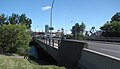
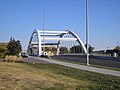
Connects Maple Ridge to Douglasdale at the Anderson Road alignment; named after John Ivor Strong, Chief Commissioner for the City of Calgary from 1965 to 1971
Douglasdale Park Pedestrian BridgePedestrian 50°56′27″N114°00′40″W / 50.94090°N 114.01109°W / 50.94090; -114.01109 (Douglasdale Park Pedestrian Bridge) Connects Douglasdale Park to Queensland
McKenzie Pedestrian BridgePedestrian 50°54′42″N113°59′54″W / 50.91178°N 113.99827°W / 50.91178; -113.99827 (McKenzie Pedestrian Bridge) Connects Deer Ridge with McKenzie Lake
Marquis de Lorne Bridges Stoney Trail 2009/2023 [8] 50°53′40″N114°00′34″W / 50.89435°N 114.00937°W / 50.89435; -114.00937 (Marquis de Lorne Bridge) Marquis de Lorne Bridge.JPG Connects Stoney Trail from Sundance and Chaparral across Fish Creek Provincial Park to McKenzie Lake and Cranston
Chapparal Pedestrian BridgePedestrian2023 50°53′31″N114°00′27″W / 50.891817°N 114.007419°W / 50.891817; -114.007419 (Chapparal Pedestrian Bridge) Connects Chapparal to Cranston
Dunbow Bridges Deerfoot Trail 50°51′15″N113°58′15″W / 50.85420°N 113.97095°W / 50.85420; -113.97095 (Dunbow Road Bridge) Connects Deerfoot Trail to Macleod Trail south of Calgary, between Cranston/Seton and Heritage Pointe

Elbow River

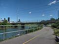
The Elbow River enters the city in the southwest, then turns north and merges into the Bow River immediately east of downtown. From west to north, the following structures cross the river.

BridgeCarriesLengthBuiltCoordinatesImageRemarks
Twin Bridges Highway 8 51°01′01″N114°14′25″W / 51.01693°N 114.24017°W / 51.01693; -114.24017 (Stoney Trail) Highway 8 named Stoney Trail east of this point
Weaselhead Road BridgeWeasel Head Road 50°59′33″N114°10′06″W / 50.992513°N 114.168360°W / 50.992513; -114.168360 (Weaselhead Road bridge) Private bridge for road traffic, inside the limits of the Tsuut'ina Nation reserve
Tsuu'tina Trail Bridges Tsuu'tina Trail 50°59′33″N114°10′06″W / 50.992513°N 114.168360°W / 50.992513; -114.168360 (Tsuu'tina Trail Bridges) Bridges going north and southbound on Tsuu'tina Trail over the Elbow
Weaselhead Pedestrian BridgePedestrian 50°59′29″N114°8′48″W / 50.99139°N 114.14667°W / 50.99139; -114.14667 (Weaselhead pedestrian bridge) Bridge within the Weaslehead Natural Area
Glenmore Trail Causeway Glenmore Trail 50°59′43″N114°05′57″W / 50.99530°N 114.09928°W / 50.99530; -114.09928 (Glenmore Trail bridge)
Glenmore Trail over Glenmore Reservoir Calgary downtown from glenmore reservoir.JPG
Glenmore Trail over Glenmore Reservoir
Crosses the Glenmore Reservoir
Glenmore Dam Pedestrian, maintenance road1933 51°00′00″N114°05′50″W / 50.99990°N 114.09715°W / 50.99990; -114.09715 (Glenmore Dam) Dam, created Glenmore Reservoir, allows pedestrian access and maintenance vehicles (no public vehicle access) along Glenmore Bridge Rd.
Sandy Beach BridgePedestrian1959 [9] 51°00′43″N114°05′31″W / 51.01199°N 114.09182°W / 51.01199; -114.09182 (Sandy Beach Bridge) Connects River Park (in Altadore) and Riverdale Park (in Britannia)
Elbow Park Britannia Pedestrian BridgePedestrian 51°01′08″N114°04′59″W / 51.01887°N 114.08317°W / 51.01887; -114.08317 (Elbow Park Britannia Pedestrian Bridge) Connects Elbow River bike and pathway; between Elbow Park and Britannia
Elbow Drive BridgeElbow Drive 51°01′04″N114°04′40″W / 51.01786°N 114.07788°W / 51.01786; -114.07788 (Elbow Drive bridge) Connects the neighbourhoods of Elbow Park and Britannia
Elbow Park Rideau Park Pedestrian BridgePedestrian 51°01′30″N114°04′40″W / 51.02495°N 114.07779°W / 51.02495; -114.07779 (Elbow Park Rideau Park Pedestrian Bridge) Connects Elbow River bike and pathway; between Elbow Park and Rideau Park
4 St SW Bridge4 Street SW 51°01′46″N114°04′17″W / 51.02934°N 114.07152°W / 51.02934; -114.07152 (4 Street SW bridge)
4 St SW Bridge 4StSWBridge-s01.jpg
4 St SW Bridge
Connects the neighbourhoods of Mission and Roxboro
Scollen Bridge25 Avenue SW 51°01′49″N114°03′48″W / 51.03041°N 114.06343°W / 51.03041; -114.06343 (Scollen bridge)
Scollen Bridge ScollenBridge-s01, 25 Avenue SW, en Calgary.jpg
Scollen Bridge
Connects the neighbourhoods of Mission and Erlton
21 Ave SW MNP Pedestrian BridgePedestrian 51°02′03″N114°04′03″W / 51.03421°N 114.06751°W / 51.03421; -114.06751 (21 Ave SW MNP Pedestrian bridge)
21 Ave SW MNP Pedestrian Bridge 21AveSWTalismanBridge-s01.jpg
21 Ave SW MNP Pedestrian Bridge
Between 21 Ave SW and the MNP Community & Sport Centre grounds
19 Ave SW MNP Pedestrian BridgePedestrian 51°02′09″N114°03′55″W / 51.03588°N 114.06538°W / 51.03588; -114.06538 (19 Ave SW MNP Pedestrian bridge)
19 Ave SW MNP Pedestrian Bridge 19AveSWTalismanBridge.jpg
19 Ave SW MNP Pedestrian Bridge
Between 19 Ave SW (behind St. Mary's Cathedral and the MNP Community & Sport Centre grounds
Pattison Bridge Macleod Trail South 51°02′10″N114°03′41″W / 51.03600°N 114.06126°W / 51.03600; -114.06126 (Macleod Trail South bridge)
Macleod Trail South Bridge MacleodTrailSouthBridge-s01.jpg
Macleod Trail South Bridge
Between Mission and MNP Community & Sport Centre, named for John George Pattison, Victoria Cross recipient of the 50th Battalion, CEF. [10]
Victoria Bridge Macleod Trail North 51°02′04″N114°03′33″W / 51.03448°N 114.05911°W / 51.03448; -114.05911 (Victoria Bridge)
Victoria Bridge VictoriaBridge-s01.jpg
Victoria Bridge
Between Mission and MNP Community & Sport Centre
Macleod Train Bridge C-Train 51°2′2″N114°3′32″W / 51.03389°N 114.05889°W / 51.03389; -114.05889 (Macleod Train Bridge)
Macleod Train Bridge MacleodCTrainBridge-s01.jpg
Macleod Train Bridge
Between Mission and MNP Community & Sport Centre
Stampede Trail BridgeStampede Trail SE 51°01′58″N114°03′24″W / 51.03265°N 114.05675°W / 51.03265; -114.05675 (Stampede Trail bridge)
Stampede Trail Bridge StampedeTrailBridge-s01.jpg
Stampede Trail Bridge
Provides entry into the Calgary Stampede grounds and access to the Stampede Grandstand
Stampede Ground Bridgemaintenance road 51°1′52″N114°3′2″W / 51.03111°N 114.05056°W / 51.03111; -114.05056 (Stampede ground bridge)
Stampede Ground Bridge StampedeGroundBridge1-s01.jpg
Stampede Ground Bridge
Provides access Calgary Stampede ground buildings
Stampede Ground Bridgemaintenance road 51°1′53″N114°3′1″W / 51.03139°N 114.05028°W / 51.03139; -114.05028 (Stampede ground bridge)
Stampede Ground Bridge StampedeGroundBridge2-s01.jpg
Stampede Ground Bridge
Provides access Calgary Stampede ground buildings
Saddledome Trail BridgePedestrian 51°2′13″N114°2′59″W / 51.03694°N 114.04972°W / 51.03694; -114.04972 (Saddledome bridge)
Saddledome Trail Bridge SaddledomeTrailBridge-s01.jpg
Saddledome Trail Bridge
Provides entry into the Calgary Stampede grounds and access to the Scotiabank Saddledome
Agriculture Trail BridgeAgriculture Trail SE 51°02′19″N114°02′55″W / 51.03858°N 114.04873°W / 51.03858; -114.04873 (Agriculture Trail bridge)
Agriculture Trail Bridge AgricultureTrailBridge-s01.jpg
Agriculture Trail Bridge
Service road from Calgary Stampede grounds
Macdonald Avenue BridgeMacdonald Avenue SE1911 51°02′29″N114°02′41″W / 51.04132°N 114.04474°W / 51.04132; -114.04474 (Macdonald Avenue bridge)
Macdonald Avenue Bridge MacdonaldAvenueBridge-s01.jpg
Macdonald Avenue Bridge
Connects the neighbourhoods of Victoria Park and Ramsay
Canadian Pacific Rail Bridge (Inglewood) Canadian Pacific Railway 51°02′35″N114°02′34″W / 51.04318°N 114.04287°W / 51.04318; -114.04287 (Canadian Pacific Rail (Inglewood))
Macdonald Avenue Bridge, CPR Bridge and Inglewood Bridge ElbowRiverCalgary.jpg
Macdonald Avenue Bridge, CPR Bridge and Inglewood Bridge
Connects the Canadian Pacific Railway downtown yard with the CPR Alyth Yard
9 Ave SE (Inglewood) Bridge9 Avenue SE2022 51°02′37″N114°02′34″W / 51.04363°N 114.04277°W / 51.04363; -114.04277 (Inglewood Bridge) New 9th Avenue Bridge.jpg 
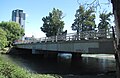
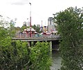
Original bridge was built in 1909 and demolished in 2019 to make room for its replacement (pictured). The Bridge provides access between Downtown East Village and Inglewood

Fish Creek

Fish Creek flows from west to east in the south part of the city, through the Fish Creek Provincial Park. It merges into the Bow River in the southeast quadrant of the city.

BridgeCarriesLengthBuiltCoordinatesImageRemarks
37 St SW Bridge37 St SW 50°55′40″N114°08′24″W / 50.92781°N 114.14005°W / 50.92781; -114.14005 (37 St SW Bridge) Connects the neighbourhoods of Woodbine and Evergreen
Fish Creek Pedestrian Bridge no. 1Pathway 50°55′44″N114°08′14″W / 50.92875°N 114.13728°W / 50.92875; -114.13728 (Fish Creek Pedestrian Bridge no. 1) Connects pathways in the Fish Creek Provincial Park
Fish Creek Pedestrian Bridge no. 2Pathway 50°55′40″N114°07′34″W / 50.92765°N 114.12604°W / 50.92765; -114.12604 (Fish Creek Pedestrian Bridge no. 2) Connects pathways in the Fish Creek Provincial Park
Fish Creek Pedestrian Bridge no. 3Pathway 50°55′35″N114°06′35″W / 50.92641°N 114.10975°W / 50.92641; -114.10975 (Fish Creek Pedestrian Bridge no. 3) Connects pathways in the Fish Creek Provincial Park
Fish Creek Pedestrian Bridge no. 4Pathway 50°55′53″N114°06′31″W / 50.93133°N 114.10870°W / 50.93133; -114.10870 (Fish Creek Pedestrian Bridge no. 4) Connects pathways in the Fish Creek Provincial Park
Fish Creek Pedestrian Bridge no. 5Pathway 50°55′59″N114°06′19″W / 50.93297°N 114.10521°W / 50.93297; -114.10521 (Fish Creek Pedestrian Bridge no. 5)
Pedestrian Bridge in Fish Creek Park Fish-Creek-Park-Szmurlo.jpg
Pedestrian Bridge in Fish Creek Park
Connects pathways in the Fish Creek Provincial Park
Fish Creek Pedestrian Bridge no. 6Pathway 50°56′03″N114°06′15″W / 50.93405°N 114.10411°W / 50.93405; -114.10411 (Fish Creek Pedestrian Bridge no. 6) Connects pathways in the Fish Creek Provincial Park
Fish Creek Pedestrian Bridge no. 7Pathway 50°56′02″N114°05′51″W / 50.93400°N 114.09750°W / 50.93400; -114.09750 (Fish Creek Pedestrian Bridge no. 7) Connects pathways in the Fish Creek Provincial Park
CPR Bridge (Fish Creek) Canadian Pacific Railway 50°55′45″N114°04′21″W / 50.92914°N 114.07238°W / 50.92914; -114.07238 (CPR Bridge (Fish Creek)) Also carriers C-Train tracks
Macleod Trail Bridge Macleod Trail 50°55′44″N114°04′11″W / 50.92895°N 114.06979°W / 50.92895; -114.06979 (Macleod Trail Bridge) Connects the neighbourhoods of Canyon Meadows and Lake Bonavista to Shawnee Slopes and Midnapore
Bow Bottom BridgeBow Bottom Trail SW 50°54′26″N114°00′54″W / 50.90714°N 114.01492°W / 50.90714; -114.01492 (Bow Bottom Bridge)
Bridge in Fish Creek Park along Bow Bottom trail Bow Bottom Bridge.JPG
Bridge in Fish Creek Park along Bow Bottom trail
Connects the neighbourhoods of Deer Run and Parkland to Sikome Lake and Fish Creek Provincial Park
Map all coordinates using: OpenStreetMap  

See also

Related Research Articles

<span class="mw-page-title-main">Glenmore Reservoir</span> Reservoir in Calgary, Alberta

The Glenmore Reservoir is a large reservoir on the Elbow River in the southwest quadrant of Calgary, Alberta. It is controlled by the Glenmore Dam, a concrete gravity dam on the Elbow River. The Glenmore Reservoir is a primary source of drinking water to the city of Calgary. Built in 1932, with a cost of $3.8 million, the dam controls the downstream flow of the Elbow River, thus allowing the city to develop property near the river's banks with less risk of flooding.

<span class="mw-page-title-main">Fish Creek Provincial Park</span> Park in Calgary, Alberta, Canada

Fish Creek Park is an urban provincial park that preserves the valley of Fish Creek in the southern part of Calgary, Alberta, Canada. It is bordered on three sides by the city, and on the west by the territory of the Tsuu T’ina Nation (Sarcee), a First Nation.

<span class="mw-page-title-main">Deerfoot Trail</span> Freeway in Calgary

Deerfoot Trail is a 46.4-kilometre (28.8 mi) freeway segment of Highway 2 in Calgary, Alberta, Canada. It stretches the entire length of the city from south to north and links suburbs to downtown via Memorial Drive and 17 Avenue SE. The freeway begins south of Calgary where it splits from Macleod Trail, crosses the Bow River into city limits, and reaches the Stoney Trail ring road. Crisscrossing twice more with the river, it intersects Glenmore Trail and Memorial Drive; the former is a major east–west expressway while the latter is a freeway spur into downtown. In north Calgary, it crosses Highway 1 and passes Calgary International Airport before ending at a second interchange with Stoney Trail. Highway 2 becomes the Queen Elizabeth II Highway as it continues north into Rocky View County towards Edmonton.

<span class="mw-page-title-main">Elbow River</span> River in Alberta, Canada

The Elbow River is a river in southern Alberta, Canada. It flows from the Canadian Rockies to the city of Calgary, where it merges into the Bow River.

<span class="mw-page-title-main">Red Deer River</span> River in Alberta and Saskatchewan, Canada

The Red Deer River is a river in Alberta and a small portion of Saskatchewan, Canada. It is a major tributary of the South Saskatchewan River and is part of the larger Saskatchewan-Nelson system that empties into Hudson Bay.

<span class="mw-page-title-main">Stoney Trail</span> Freeway in Calgary, Alberta

Alberta Provincial Highway No. 201, officially named Stoney Trail and Tsuut'ina Trail, is an approximately 92-kilometre (57 mi) freeway in Calgary, Alberta. It forms part of the CANAMEX Corridor which connects Calgary to Edmonton and Interstate 15 in the United States via Highways 2, 3, and 4. Planned for a total length of 101 kilometres, the final segment of the ring road is currently under construction to be completed by 2024 at the latest, delayed from an original target of 2022. The freeway serves as a bypass for the congested routes of 16 Avenue N and Deerfoot Trail through Calgary. At its busiest point near Beddington Trail in north Calgary, the six-lane freeway carried nearly 79,000 vehicles per day in 2019.

Alberta Provincial Highway No. 8, commonly referred to as Highway 8, is a highway in Southern Alberta that connects Highway 22 in Rocky View County, just north of Redwood Meadows, to Calgary.

The city of Calgary, Alberta, has a large transportation network that encompasses a variety of road, rail, air, public transit, and pedestrian infrastructure. Calgary is also a major Canadian transportation centre and a central cargo hub for freight in and out of north-western North America. The city sits at the junction between the "Canamex" highway system and the Trans-Canada Highway.

Glenmore Trail is a 22-kilometre (14 mi) expressway in Calgary, Alberta, Canada, named after the reservoir which it crosses. It is a freeway between Sarcee Trail in southwest Calgary to Ogden Road in the southeast, carrying nearly 160,000 vehicles per weekday at its busiest point placing it second only to Deerfoot Trail as the busiest road in Alberta. East of Calgary, Glenmore Trail becomes Highway 560 en route to Langdon.

<span class="mw-page-title-main">Albert Park/Radisson Heights</span> Neighbourhood in Calgary, Alberta, Canada

Albert Park/Radisson Heights is a residential neighbourhood in the southeast quadrant of Calgary, Alberta. It is bounded to the west by the Bow River and Deerfoot Trail, to the north by Memorial Drive and to the south by 17 Avenue SE. The community of Forest Lawn lies to the east.

<span class="mw-page-title-main">Bridgeland, Calgary</span> Neighbourhood in Calgary, Alberta, Canada

Bridgeland-Riverside, formerly known as Bridgeland and Germantown, is a neighbourhood in Calgary, Alberta, Canada, is located northeast of Downtown Calgary. It is bounded to the south by the Bow River, to the east by Deerfoot Trail, to the west by Edmonton Trail and to the north by the community of Renfrew.

Renfrew is a residential neighbourhood in the northeast quadrant of Calgary, Alberta. It is located south of the Trans-Canada Highway, and north of the inner city community of Bridgeland. To the east it is bordered by the Nose Hill Creek and the Deerfoot Trail and is separated from Crescent Heights to the west by Edmonton Trail.

<span class="mw-page-title-main">Macleod Trail</span> Road in Calgary

Macleod Trail is a major road in Calgary, Alberta. It is a six- to eight-lane principal arterial road extending from downtown Calgary to the south of the city, where it merges into Highway 2. South of Anderson Road, Macleod Trail is an expressway and is slated to be upgraded to a freeway in the future. It is named for its destination to the south, Fort Macleod.

<span class="mw-page-title-main">Calgary</span> Largest city in Alberta, Canada

Calgary is a city in the Canadian province of Alberta. It is the largest city in Alberta and the largest metro area within the three Prairie Provinces region. As of 2021, the city proper had a population of 1,306,784 and a metropolitan population of 1,481,806, making it the third-largest city and fifth-largest metropolitan area in Canada.

<span class="mw-page-title-main">Reconciliation Bridge</span> Bridge in Calgary, Alberta, Canada

The Reconciliation Bridge is a through truss bridge in Calgary, Alberta, Canada. It connects Downtown Calgary with north-central Calgary communities such as Bridgeland and Crescent Heights, by spanning the Bow River between 4th Avenue South and Memorial Drive.

<span class="mw-page-title-main">Downtown East Village, Calgary</span> Neighbourhood in Calgary, Alberta, Canada

Downtown East Village more commonly known as simply East Village, is a mixed-use neighbourhood within the eastern portions of downtown Calgary, Alberta, Canada. It is contained within the city's Rivers District. Containing the earliest-settled land in the Calgary area - Fort Calgary - East Village was for years a mixture of high-rise residential, commercial, and industrial development. Much of the parkland currently surrounding Fort Calgary was industrial as recently as the 1960s. Construction of the city's light rail transit Blue Line, coupled with the closure of 8th Avenue at Macleod Trail in the early 1980s by construction of the massive Calgary Municipal Building, resulted in East Village being "cut off," figuratively speaking, from the rest of downtown. As a result, it became home to many rundown properties and vacant lots over the years, and a severe crime problem.

<span class="mw-page-title-main">2013 Alberta floods</span> Natural disaster in southern Alberta, Canada

In the days leading up to June 19, 2013, parts of southern and central Alberta, Canada experienced heavy rainfall that triggered catastrophic flooding described by the provincial government as the worst in Alberta's history. Areas along the Bow, Elbow, Highwood, Red Deer, Sheep, Little Bow, and South Saskatchewan rivers and their tributaries were particularly affected. A total of 32 states of local emergency were declared and 28 emergency operations centres were activated as water levels rose and numerous communities were placed under evacuation orders.

<span class="mw-page-title-main">14 Street W (Calgary)</span>

14 Street W is the name of two major arterial roads and a short collector road in Calgary, Alberta. Separated by the Elbow River and the West Nose Creek valley. Originally proposed as a continuous route and north-south freeway, plans were cancelled in favor of 24 Street W, which became Crowchild Trail.

Calgary Trail and Gateway Boulevard are a pair of major arterial roadways in Edmonton, Alberta. Gateway Boulevard carries northbound traffic while Calgary Trail carries southbound traffic. From south of 31 Avenue, they form a two-way freeway separated by a median; for this portion, the roadway maintains the separate names for northbound and southbound traffic. Near 31 Avenue, Calgary Trail and Gateway Boulevard separate and become parallel one-way arterial roadways to Saskatchewan Drive, at the edge of the North Saskatchewan River valley. Designated as part of Highway 2 south of Whitemud Drive, it is Edmonton's main southern entrance and is both a major commuter route, connecting to the Edmonton International Airport and Leduc, as well as a regional connection to Red Deer and Calgary.

References

  1. TransAlta Utilities. "Bearspaw" . Retrieved 2009-09-19.
  2. 1 2 Fletcher, Robson (January 27, 2014). "Four Calgary bridges recognized for their historical significance". Calgary Metro. Metro News. Retrieved December 16, 2016.
  3. 1 2 "Hon. William Henry Cushing" . Retrieved 2009-09-07.
  4. Glenbow Museum. "Langevin bridges". Archived from the original on 2009-01-05. Retrieved 2009-12-24.
  5. CBC (2010-03-22). "Calgary-Paris partners to build St. Patrick's bridge". CBC News. Retrieved 2010-04-08.
  6. "Calgary Mayor Naheed Nenshi railing after Bonnybrook train bridge collapses over Bow River". Calgary Sun. Retrieved Aug 22, 2020.
  7. City of Calgary. "Graves Bridge Twinning" . Retrieved 2009-09-07.
  8. City of Calgary (2008-07-17). "Marquis of Lorne Trail S.E. / Bow River Bridge Project". Archived from the original on 2009-08-19. Retrieved 2009-09-07.
  9. "City of Calgary Parks Department Annual Report 1959" (PDF). calgary.ca. Retrieved 2022-06-11.
  10. "Soldier led Vimy Charge" Retrieved 29 March 2009