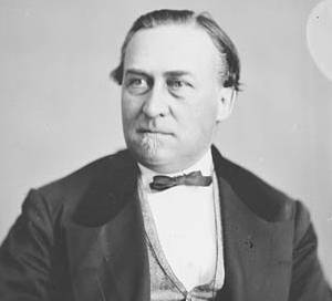
Sir Hector-Louis Langevin, was a Canadian lawyer, politician, and one of the Fathers of Confederation.
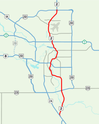
Deerfoot Trail is a 46.4-kilometre (28.8 mi) freeway segment of Highway 2 in Calgary, Alberta, Canada. It stretches the entire length of the city from south to north and links suburbs to downtown via Memorial Drive and 17 Avenue SE. The freeway begins south of Calgary where it splits from Macleod Trail, crosses the Bow River into city limits, and reaches the Stoney Trail ring road. Crisscrossing twice more with the river, it intersects Glenmore Trail and Memorial Drive; the former is a major east–west expressway while the latter is a freeway spur into downtown. In north Calgary, it crosses Highway 1 and passes Calgary International Airport before ending at a second interchange with Stoney Trail. Highway 2 becomes the Queen Elizabeth II Highway as it continues north into Rocky View County towards Red Deer and Edmonton.

The Plus 15 or +15 is a skyway network in Calgary, Alberta, Canada. It is the world's most extensive pedestrian skywalk system, with a total length of 16 kilometres and 86 bridges connecting 130 buildings, as of 2022. Calgary often has severe winters and the walkways allow people to get around the city's downtown more quickly and comfortably. The busiest parts of the network saw over 20,000 pedestrians per day in a 2018 count.

Alberta Provincial Highway No. 201, officially named Stoney Trail and Tsuut'ina Trail, is a 101-kilometre (63 mi) freeway that encircles the city of Calgary, Alberta. It serves as a bypass for the congested routes of 16 Avenue N and Deerfoot Trail through Calgary. At its busiest point near Beddington Trail in north Calgary, the six-lane freeway carried nearly 60,000 vehicles per day in 2022, and forms part of the CANAMEX Corridor which connects Calgary to Edmonton and Interstate 15 in the United States via Highways 2, 3, and 4.

The neighbourhood of Eau Claire in Calgary, Alberta, Canada is located immediately north of Downtown, and south of the Bow River and north of 4th Avenue. A mix of riverside condominiums, shopping, restaurants, hotels, a large public plaza and urban parkland make Eau Claire one of Calgary's most popular areas. Contained within Eau Claire is the city's Festival District.

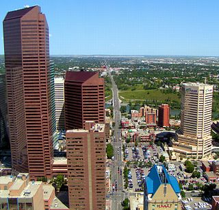
Downtown Calgary is a dense urban district in central Calgary, Alberta. It contains the second largest concentration of head offices in Canada, despite only being the country's fourth largest city in terms of population. The downtown is divided into several residential, commercial, corporate, and mixed-use neighbourhoods, including the Financial District (CBD), Eau Claire, Chinatown, East Village, Beltline, and the West End.
Crowchild Trail is a major expressway in western Calgary, Alberta. The segment from the 12 Mile Coulee Road at the edge of the city to 16 Avenue NW is designated as Highway 1A by Alberta Transportation. The road is a critical north-south link in West Calgary for both downtown bound traffic and travel between the two quadrants of the city it passes through. Although planned to be one single freeway from Glenmore Trail to the city limits, the route is currently divided by a section of slow moving arterial road with four signalized intersections between 24 Avenue and Memorial Drive. This causes the freeway in the northwest to separated from the freeway south of the Bow River. Filling the gap and making the whole route a minimum six lane freeway is currently planned for construction beyond 2027.
The city of Calgary, Alberta, has a large transportation network that encompasses a variety of road, rail, air, public transit, and pedestrian infrastructure. Calgary is also a major Canadian transportation centre and a central cargo hub for freight in and out of north-western North America. The city sits at the junction between the "Canamex" highway system and the Trans-Canada Highway.

Sunnyside is an innercity community in Calgary, Alberta located on the north side of the Bow River immediately adjacent to Calgary's downtown. The community partners with the neighbouring community of Hillhurst to form the Hillhurst-Sunnyside Community Association. The combined communities have an area redevelopment plan in place, revised in 2009.

Memorial Drive is a major road in Calgary, Alberta. Aside from its important role in city infrastructure, the tree lined sides of Memorial Drive serve as a living testament to the many local soldiers who died during World War I and give it a parkway look on the western section. An active path system also runs along the south side of Memorial Drive, beside the banks of the Bow River. The Calgary Soldiers' Memorial forms part of an extensive renovation to Memorial Drive, which heightens the function of the road as a monument to the city's military. The Landscape of Memory Project began in 2004, in order to revitalize a nine kilometre stretch of the road. The design incorporated "Poppy Plaza" at the corner of Memorial Drive and 10th Street NW. The plaza used "weathered steel" to create large gateways, and the plaza and adjacent river walk were lined with the same rusted metal into which quotes about the Canadian experiences of war were cut. The Peace Bridge was incorporated into the remembrance theme of Memorial Drive, though there are no explanatory plaques at the site of the bridge.

Bridgeland-Riverside, formerly known as Bridgeland and Germantown, is a neighbourhood in Calgary, Alberta, Canada, is located northeast of Downtown Calgary. It is bounded to the south by the Bow River, to the east by Deerfoot Trail, to the west by Edmonton Trail and to the north by the community of Renfrew.
Centre Street is a major road in Calgary, Alberta, and defines the east and west halves of the city for the purposes of street addresses.
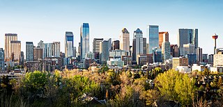
Calgary is the largest city in the Canadian province of Alberta. It is the largest metro area within the three Prairie provinces region. As of 2021, the city proper had a population of 1,306,784 and a metropolitan population of 1,481,806, making it the third-largest city and fifth-largest metropolitan area in Canada.

Edmonton Trail is a major north-south arterial road in the northeast quadrant of Calgary, Alberta. The road connects Downtown Calgary from Reconciliation Bridge and the 5th Avenue Flyover at Memorial Drive with north-central Calgary. Between Memorial Drive and 16 Avenue NE, Edmonton Trail is lined with restaurants and retail businesses.

Downtown East Village more commonly known as simply East Village, is a mixed-use neighbourhood within the eastern portions of downtown Calgary, Alberta, Canada. It is contained within the city's Rivers District. Containing the earliest-settled land in the Calgary area - Fort Calgary - East Village was for years a mixture of high-rise residential, commercial, and industrial development. Much of the parkland currently surrounding Fort Calgary was industrial as recently as the 1960s. Construction of the city's light rail transit Blue Line, coupled with the closure of 8th Avenue at Macleod Trail in the early 1980s by construction of the massive Calgary Municipal Building, resulted in East Village being "cut off," from the rest of downtown. It became home to many rundown properties and vacant lots over the years, and a severe crime problem.

16 Avenue N is a major road in Calgary, Alberta, that forms a 26.5-kilometre (16.5 mi) segment of Highway 1 and connects Calgary to Banff and Medicine Hat. It is a four to six-lane principal arterial expressway at its extremities, but is an urban arterial road between the Bow River and Bowness Road, and also between Crowchild Trail and Deerfoot Trail. Due to Calgary's quadrant system, it is known as 16 Avenue NW west of Centre Street and 16 Avenue NE to the east.

The Jack and Jean Leslie RiverWalk is a 2 kilometres (1.2 mi) section of the Bow River pathway between the Centre Street Bridge and the 9th Avenue SE Bridge, along the Bow and Elbow rivers in Downtown Calgary, Alberta, Canada. Phase III of stage 1 of the project was opened by the Calgary Municipal Land Corporation (CMLC) on September 27, 2012. Upon completion of all three stages of the project, the RiverWalk will stretch four kilometres, from the Centre Street Bridge on the Bow River to Lindsay Park along the Elbow River. In March 2015, the Jack and Jean Leslie RiverWalk was the recipient of the National Merit Award from the Canadian Society of Landscape Architects. The RiverWalk is part of a larger development of Calgary's East Village as part of that neighbourhood's area redevelopment plan.
Calgary Trail and Gateway Boulevard are a pair of major arterial roadways in Edmonton, Alberta. Gateway Boulevard carries northbound traffic while Calgary Trail carries southbound traffic. From south of 31 Avenue, they form a two-way freeway separated by a median; for this portion, the roadway maintains the separate names for northbound and southbound traffic. Near 31 Avenue, Calgary Trail and Gateway Boulevard separate and become parallel one-way arterial roadways to Saskatchewan Drive, at the edge of the North Saskatchewan River valley. Designated as part of Highway 2 south of Whitemud Drive, it is Edmonton's main southern entrance and is both a major commuter route, connecting to the Edmonton International Airport and Leduc, as well as a regional connection to Red Deer and Calgary.