
Alberta Provincial Highway No. 2, commonly referred to as Highway 2 or the Queen Elizabeth II Highway, is a major highway in Alberta that stretches from the Canada–United States border through Calgary and Edmonton to Grande Prairie. Running primarily north to south for approximately 1,273 kilometres (791 mi), it is the longest and busiest highway in the province carrying more than 170,000 vehicles per day near Downtown Calgary. The Fort Macleod—Edmonton section forms a portion of the CANAMEX Corridor that links Alaska to Mexico. More than half of Alberta's 4 million residents live in the Calgary–Edmonton Corridor created by Highway 2.

Deerfoot Trail is a 46.4-kilometre (28.8 mi) freeway segment of Highway 2 in Calgary, Alberta, Canada. It stretches the entire length of the city from south to north and links suburbs to downtown via Memorial Drive and 17 Avenue SE. It also forms part of the CANAMEX Corridor which connects Calgary to Edmonton and Interstate 15 in the United States via Highways 3 and 4. The freeway begins south of Calgary where it splits from Macleod Trail, crosses the Bow River into city limits, and reaches the Stoney Trail ring road. Crisscrossing twice more with the river, it intersects Glenmore Trail and Memorial Drive; the former is a major east–west expressway while the latter is a freeway spur into downtown. In north Calgary, it crosses Highway 1 and passes Calgary International Airport before ending at a second interchange with Stoney Trail. Highway 2 becomes the Queen Elizabeth II Highway as it continues north into Rocky View County towards Edmonton.

Alberta Provincial Highway No. 2A is the designation of six alternate routes off Highway 2 in Alberta, Canada. In general, these are original sections of Highway 2, such as the southern portion of Macleod Trail in Calgary. They passed through communities before limited-access freeways were built to shorten driving distance, accommodate heavier volumes and to bypass city traffic. Portions of the alignment of Highway 2A follow the route of the former Calgary and Edmonton Trail.

Alberta Provincial Highway No. 4, commonly referred to as Highway 4, is a 103-kilometre (64 mi) highway in southern Alberta, Canada that connects Highway 3 in Lethbridge to Interstate 15 in Montana. The highway was designated in 1999 as the First Special Service Force Memorial Highway in honour of elite soldiers who travelled to Helena, Montana for training before World War II. The highway continues into the United States retaining that name.
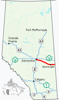
Alberta Provincial Highway No. 14, commonly referred to as Highway 14, is an east-west highway in central Alberta, Canada. It stretches from Edmonton through Wainwright to the Alberta–Saskatchewan border, running parallel to the more northern Highway 16. Highway 14 is about 257 kilometres (160 mi) long.
Crowchild Trail is a major expressway in western Calgary, Alberta. The segment from the 12 Mile Coulee Road at the edge of the city to 16 Avenue NW is designated as Highway 1A by Alberta Transportation. The road is a critical north-south link in West Calgary for both downtown bound traffic and travel between the two quadrants of the city it passes through. Although planned to be one single freeway from Glenmore Trail to the city limits, the route is currently divided by a section of slow moving arterial road with four signalized intersections between 24 Avenue and Memorial Drive. This causes the freeway in the northwest to separated from the freeway south of the Bow River. Filling the gap and making the whole route a minimum six lane freeway is currently planned for construction beyond 2027.

Sherwood Park Freeway is a 7.1-kilometre (4.4 mi) freeway that connects east Edmonton to Sherwood Park in Alberta, Canada. It begins in the Gainer Industrial area where Argyll Road and 82 (Whyte) Avenue merge before intersecting 50 Street. It then curves slightly northeast through industrial areas in southeast Edmonton across 34 Street into Strathcona County, then across 17 Street after which the freeway ends at Anthony Henday Drive. It then continues into Sherwood Park as Wye Road (Highway 630). It is primarily a commuter route, with heavier weekday volume westbound in the morning and eastbound in the afternoon as residents of Sherwood Park commute to Edmonton.

Memorial Drive is a major road in Calgary, Alberta. Aside from its important role in city infrastructure, the tree lined sides of Memorial Drive serve as a living testament to the many local soldiers who died during World War I and give it a parkway look on the western section. An active path system also runs along the south side of Memorial Drive, beside the banks of the Bow River. The Calgary Soldiers' Memorial forms part of an extensive renovation to Memorial Drive, which heightens the function of the road as a monument to the city's military. The Landscape of Memory Project began in 2004, in order to revitalize a nine kilometre stretch of the road. The design incorporated "Poppy Plaza" at the corner of Memorial Drive and 10th Street NW. The plaza used "weathered steel" to create large gateways, and the plaza and adjacent river walk were lined with the same rusted metal into which quotes about the Canadian experiences of war were cut. The Peace Bridge was incorporated into the remembrance theme of Memorial Drive, though there are no explanatory plaques at the site of the bridge.
Centre Street is a major road in Calgary, Alberta, and defines the east and west halves of the city for the purposes of street addresses.

Macleod Trail is a major road in Calgary, Alberta. It is a six- to eight-lane principal arterial road extending from downtown Calgary to the south of the city, where it merges into Highway 2. South of Anderson Road, Macleod Trail is an expressway and is slated to be upgraded to a freeway in the future. It is named for its destination to the south, Fort Macleod.

Wayne Gretzky Drive is a freeway in Edmonton, Alberta. Originally Capilano Drive/Capilano Freeway, it was officially renamed October 1, 1999 after NHL hockey player Wayne Gretzky, as a tribute to his years with the Edmonton Oilers. The same day, Wayne Gretzky's number 99 jersey was retired at the Skyreach Centre, which lies just west of Wayne Gretzky Drive, at 118 Avenue. 66/75 Street is a major arterial road in east Edmonton which serves residential and industrial areas.
97/98/101 Avenue and Baseline Road is a major arterial road in central Edmonton and north Sherwood Park, Alberta. It connects Downtown Edmonton with the mature residential neighborhoods on the city's eastern edge, as well as Refinery Row and Sherwood Park.
John Laurie Boulevard / McKnight Boulevard is a major east-west arterial road and expressway in north Calgary, Alberta. The two roadways function together as a major crosstown route between the northwest and northeast quadrants and are part of Calgary's Skeletal Road Network.
Blackfoot Trail is a super-4 expressway in Calgary, Alberta. It is named for the Blackfoot Confederacy, and more specifically the Siksika Nation, located east of Calgary. The road runs from 17 Avenue SE in the north, where Blackfoot Trail meets Deerfoot Trail, to Southland Drive in the south. It is the historical alignment of Highway 2 in south Calgary. The section of Blackfoot Trail between 19 Street SE and Deerfoot Trail is a former alignment, and still technically part of, 17 Avenue SE; however, it is generally referred to as being part of Blackfoot Trail.
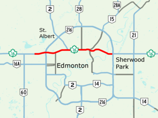
Yellowhead Trail is a 24.6-kilometre (15.3 mi) expressway segment of the Yellowhead Highway in northern Edmonton, Alberta, Canada. It carries a significant amount of truck traffic to and from the industrial areas of north Edmonton and serves as a key commuter route for the bedroom communities of Stony Plain, Spruce Grove, and Sherwood Park, carrying nearly 80,000 vehicles per weekday in 2015. A suburban bypass of the route was completed when the northeast leg of Anthony Henday Drive (Highway 216) opened in late 2016, providing an alternate route through north Edmonton.

16 Avenue N is a major road in Calgary, Alberta, that forms a 26.5-kilometre (16.5 mi) segment of Highway 1 and connects Calgary to Banff and Medicine Hat. It is a four to six-lane principal arterial expressway at its extremities, but is an urban arterial road between the Bow River and Bowness Road, and also between Crowchild Trail and Deerfoot Trail. Due to Calgary's quadrant system, it is known as 16 Avenue NW west of Centre Street and 16 Avenue NE to the east.
Calgary Trail and Gateway Boulevard are a pair of major arterial roadways in Edmonton, Alberta. Gateway Boulevard carries northbound traffic while Calgary Trail carries southbound traffic. From south of 31 Avenue, they form a two-way freeway separated by a median; for this portion, the roadway maintains the separate names for northbound and southbound traffic. Near 31 Avenue, Calgary Trail and Gateway Boulevard separate and become parallel one-way arterial roadways to Saskatchewan Drive, at the edge of the North Saskatchewan River valley. Designated as part of Highway 2 south of Whitemud Drive, it is Edmonton's main southern entrance and is both a major commuter route, connecting to the Edmonton International Airport and Leduc, as well as a regional connection to Central Alberta, and Calgary.
36 Street E, Métis Trail, and Dwight McLellan Trail is a major arterial road in eastern Calgary and Rocky View County, Alberta. It connects with residential neighborhoods and commercial corridors in northeast Calgary.
