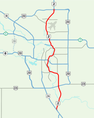
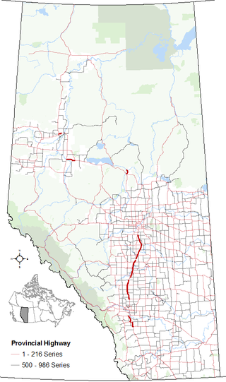
Deerfoot Trail is a 46.4-kilometre (28.8 mi) freeway segment of Highway 2 in Calgary, Alberta, Canada. It stretches the entire length of the city from south to north and links suburbs to downtown via Memorial Drive and 17 Avenue SE. The freeway begins south of Calgary where it splits from Macleod Trail, crosses the Bow River into city limits, and reaches the Stoney Trail ring road. Crisscrossing twice more with the river, it intersects Glenmore Trail and Memorial Drive; the former is a major east–west expressway while the latter is a freeway spur into downtown. In north Calgary, it crosses Highway 1 and passes Calgary International Airport before ending at a second interchange with Stoney Trail. Highway 2 becomes the Queen Elizabeth II Highway as it continues north into Rocky View County towards Red Deer and Edmonton.
Highway 2A is the designation of six alternate routes off Highway 2 in Alberta, Canada. In general, these are original sections of Highway 2, such as the southern portion of Macleod Trail in Calgary. They passed through communities before limited-access freeways were built to shorten driving distance, accommodate heavier volumes and to bypass city traffic. Portions of the alignment of Highway 2A follow the route of the former Calgary and Edmonton Trail.

Highway 201, better known by its official names of Stoney Trail and Tsuut'ina Trail, is a 101-kilometre (63 mi) freeway that encircles Calgary, Alberta. It serves as a bypass for the congested routes of 16 Avenue N and Deerfoot Trail through Calgary. At its busiest point near Beddington Trail in north Calgary, the six-lane freeway carried nearly 60,000 vehicles per day in 2022, and forms part of the CANAMEX Corridor which connects Calgary to Edmonton and Interstate 15 in the United States via Highways 2, 3, and 4.
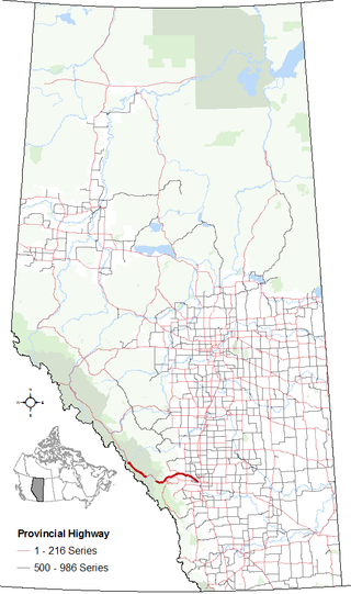
Highway 1 is a major east–west highway in southern Alberta that forms the southern mainline of the Trans-Canada Highway. It runs from the British Columbia border near Lake Louise through Calgary to the Saskatchewan border east of Medicine Hat. It continues as Highway 1 into both provinces. It spans approximately 534 km (332 mi) from Alberta's border with British Columbia in the west to its border with Saskatchewan in the east. Highway 1 is designated as a core route in Canada's National Highway System and is a core part of the developing Alberta Freeway Network.
Highway 1A is the designation of two alternate routes off the Alberta portion of Trans-Canada Highway 1. However, it is not the only name used for spurs off Highway 1 - Highway 1X is another such designation. Despite these highways being suffixed routes of Highway 1, they are not part of the Trans-Canada Highway network, and are signed with Alberta's provincial primary highway shields instead of the Trans-Canada shields used for Highway 1.
Highway 8 is a highway in Southern Alberta that connects Highway 22 in Rocky View County, just north of Redwood Meadows, to Calgary.

Highway 14 is an east-west highway in central Alberta, Canada. It stretches from Edmonton through Wainwright to the Alberta–Saskatchewan border, running parallel to the more northern Highway 16. Highway 14 is about 257 kilometres (160 mi) long.
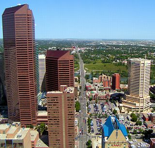
Centre Street is a major road in Calgary, Alberta, and defines the east and west halves of the city for the purposes of street addresses.

Shaganappi Trail is a major super-4 expressway in the northwest quadrant of Calgary, Alberta. It extends to the south as Montgomery View, a small service road in the neighbourhood of Montgomery and that provides access to Edworthy Park, passes north past Market Mall and the western boundary of Nose Hill Park, and terminates in the neighbourhood of Nolan Hill in the north, with city planning maps indicating future northern extension beyond 144 Avenue NW. The name "Shaganappi" is of Cree origin, referring to the bison hide lacings that held Red River ox carts together. Despite the name, it is not located near the Shaganappi neighbourhood, which is located south of the Bow River.
23 Avenue NW is a major arterial road in south Edmonton. It runs through several neighbourhoods including Mill Woods and The Meadows, and commercial areas including South Edmonton Common, and Mill Woods Town Centre. In September 2011, construction completed of an interchange at the intersection with Calgary Trail & Gateway Boulevard (Highway 2); considered Edmonton's busiest intersection. Because Edmonton has adapted a quadrant system, the suffix NW is sometimes added to addresses, to avoid confusion with addresses south of Quadrant (1) Avenue.
97/98/101 Avenue and Baseline Road is a major arterial road in central Edmonton and north Sherwood Park, Alberta. It connects Downtown Edmonton with the mature residential neighborhoods on the city's eastern edge, as well as Refinery Row and Sherwood Park.
Sarcee Trail is a major limited-access road in Calgary, Alberta. It is divided into two portions, one in the south end of the city, and one in the north end of the city. Originally planned as one continuous route, plans to connect the two halves have been shelved as it would involve the demolition of homes in Bowness and the disruption of the Bowmont Natural Area park. The urban arterial road is named for the Tsuu T'ina, who were also known as the Sarcee.
John Laurie Boulevard / McKnight Boulevard is a major east-west arterial road and expressway in north Calgary, Alberta. The two roadways function together as a major crosstown route between the northwest and northeast quadrants and are part of Calgary's Skeletal Road Network.
Barlow Trail is a major arterial road in Calgary, Alberta, that is composed of three parts: the southern section which runs from Deerfoot Trail near 130 Avenue SE to Deerfoot Trail at the intersection with Peigan Trail. The afore mentioned section is the central section which runs from 17 Avenue SE to McCall Way; and the northern section which runs from Airport Road to 128 Avenue NE.
Blackfoot Trail is a super-4 expressway in Calgary, Alberta. It is named for the Blackfoot Confederacy, and more specifically the Siksika Nation, located east of Calgary. The road runs from 17 Avenue SE in the north, where Blackfoot Trail meets Deerfoot Trail, to Southland Drive in the south. It is the historical alignment of Highway 2 in south Calgary. The section of Blackfoot Trail between 19 Street SE and Deerfoot Trail is a former alignment, and still technically part of, 17 Avenue SE; however, it is generally referred to as being part of Blackfoot Trail.

16 Avenue N is a major road in Calgary, Alberta, that forms a 26.5-kilometre (16.5 mi) segment of Highway 1 and connects Calgary to Banff and Medicine Hat. It is a four to six-lane principal arterial expressway at its extremities, but is an urban arterial road between the Bow River and Bowness Road, and also between Crowchild Trail and Deerfoot Trail. Due to Calgary's quadrant system, it is known as 16 Avenue NW west of Centre Street and 16 Avenue NE to the east.

14 Street W is the name of two major arterial roads and a short collector road in Calgary, Alberta, separated by the Elbow River and the West Nose Creek valley. Originally proposed as a continuous route and north-south freeway, the plans were cancelled in favor of 24 Street W, which became Crowchild Trail.

17 Avenue SE is a major arterial road in east Calgary, Alberta. 17 Avenue SE is the focal point of the International Avenue Business Revitalization Zone (BRZ) and the main roadway through the former town of Forest Lawn. Chestermere Boulevard is a major arterial road and the eastern extension of 17 Avenue SE through Chestermere, Alberta, Canada. The roadway is a former alignment of Highway 1A.
Calgary Trail and Gateway Boulevard are a pair of major arterial roadways in Edmonton, Alberta. Gateway Boulevard carries northbound traffic while Calgary Trail carries southbound traffic. From south of 31 Avenue, they form a two-way freeway separated by a median; for this portion, the roadway maintains the separate names for northbound and southbound traffic. Near 31 Avenue, Calgary Trail and Gateway Boulevard separate and become parallel one-way arterial roadways to Saskatchewan Drive, at the edge of the North Saskatchewan River valley. Designated as part of Highway 2 south of Whitemud Drive, it is Edmonton's main southern entrance and is both a major commuter route, connecting to the Edmonton International Airport and Leduc, as well as a regional connection to Red Deer and Calgary.
36 Street E, Métis Trail, and Dwight McLellan Trail is a major arterial road in eastern Calgary and Rocky View County, Alberta. It connects with residential neighborhoods and commercial corridors in northeast Calgary.
