Bridgeland, Calgary

Last updated
Bridgeland-Riverside
Riverside
Neighbourhood
Bridgeland-Calgary-2004.JPG
Bridgeland seen from Calgary Tower
Calgary street map.png
Red pog.svg
Bridgeland-Riverside
Location of Bridgeland in Calgary
Coordinates: 51°03′17″N114°02′46″W / 51.05472°N 114.04611°W / 51.05472; -114.04611
CountryCanada
Province Alberta
City Calgary
QuadrantNE
Wards 7, 9
Established1908
Annexed1910
Government
[1]
  Mayor Jyoti Gondek
  Administrative body Calgary City Council
  CouncillorsTerry Wong
Gian-Carlo Carra
Area
  Total3.2 km2 (1.2 sq mi)
Elevation
1,055 m (3,461 ft)
Population
 (2011) [2]
  Total5,254
   Median Household Income
$64,201
Postal code
T2E
Website brcacalgary.org

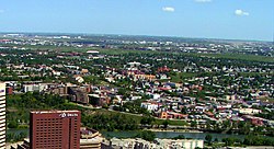
Bridgeland-Riverside, formerly known as Bridgeland and Germantown, [3] is a neighbourhood in Calgary, Alberta, Canada, is located northeast of Downtown Calgary. It is bounded to the south by the Bow River, to the east by Deerfoot Trail, to the west by Edmonton Trail and to the north by the community of Renfrew.

Contents

Omatsuri Festival in Bridgeland Omatsuri Festival in Bridgeland.jpg
Omatsuri Festival in Bridgeland

The community is primarily residential with a mix of parkside condominiums and single-family houses. Bridgeland contains a variety of restaurants, food markets, retail shopping, offices, financial services, churches and schools. The Wilder Institute/Calgary Zoo, Telus Spark, The Bridges urban renewal development and access to the city's large network of pedestrian pathways (the Bow River pathway) and parks are unique focal points for the community and surrounding region.

Bridgeland borders a natural environment composed of the confluence of the Bow River and Elbow River. Tom Campbell's Hill park lies on the eastern edge of Bridgeland and overlooks the downtown, Bow River and northeastern part of the city. [4] St. Patrick's Island and St. George's Island lie in the southern part of Bridgeland. St. George's Island is home to the Wilder Institute/Calgary Zoo, Canada's second largest zoo. [5]

Bridgeland is the site of the Telus Spark, a $160-million facility that opened on October 29, 2011 and Canada's first purpose-built science centre in more than 25 years.

History

The community of Riverside was established by Russian-German immigrants during Calgary's first population boom in the 1880s, when Riverside was known as Germantown. At the beginning of the 20th century, immigrants were mostly of Italian and Ukrainian origin. [6] [7]

The name "Bridgeland" appeared as a result of the Dominion Bridge Company operating nearby. [8]

Riverside incorporated as a village on July 6, 1903, and was subsequently annexed by the City of Calgary in 1910. In 1910, the Riverside School opened and served the community for 50 years. [9] In 1908, the Bridgeland-Riverside Community Association was founded. [8] A Red Light District survived in the neighbourhood until the First World War. In 1910, the Calgary General Hospital was built in this area. It was closed in 1997 and was demolished in a controlled explosion on October 4, 1998. [10]

Parts of lower Bridgeland were popularly known as "Little Italy" in emulation of similarly named enclaves in other cities of immigrants of Italian stock. The concentration of Italian bakeries, restaurants and groceries has diminished over time but the strip along 1st Avenue NE is sometimes still referred to by this name. [11]

The Wilder Institute/Calgary Zoo was established on St. George's Island in 1929 with 36 mammals and 78 birds. [12] By 2006, it had expanded to over 1,000 animals with 290 different species with exhibits from Destination Africa, Canadian Wilds, Australia, Botanical gardens, Eurasia, Prehistoric Park and South America. This area was severely damaged in the 2013 flood in southern Alberta.

Over 5,000 people participated in a public process that is underway in 2010 to develop a master plan for St. Patrick's Island. [13]

In modern times, the community is recognized as a "distinct bobo (bohemian/bourgeois) residential neighbourhood" [14] and having a high degree of walkability. [15] In 2013, Bridgeland/Riverside was ranked by Fast Forward Weekly magazine as the third "most livable neighbourhood" in Calgary. [16]

Demographics

In the City of Calgary's 2012 municipal census, Bridgeland/Riverside had a population of 5,594 living in 3,274 dwellings, a 6.5% increase from its 2011 population of 5,254. [17] With a land area of 3.1 km2 (1.2 sq mi), it had a population density of

The City of Calgary adopted an area redevelopment plan for this community in 2006, [19] which regulates construction of buildings and recreational areas, with the intention of increasing population density in certain areas, as well as development of a public transit oriented community.

At the beginning of the 21st century, gentrification was occurring in Bridgeland. This resulted in new residents and business moving into the community. In addition, household incomes rose by +44.7% within Bridgeland between 2005 and 2015. This compares against a household income growth of +22.7% in the rest of Calgary over the same period. [2]

Government

The community is represented in the Calgary City Council by Gian-Carlo Carra and Druh Farrell, wards 9 and 7 respectively. On a provincial level, Bridgeland is part of the Calgary-Mountain View constituency in Alberta's Legislative Assembly and is represented by Liberal MLA Dr. David Swann. On a federal level, Bridgeland falls in the electoral district of Calgary Centre-North and is represented in the House of Commons of Canada by MP Len Webber.

Recreation

Scotiabank Calgary Marathon 2009 Scotiabank Calgary Marathon.png
Scotiabank Calgary Marathon 2009

Bridgeland is the start and finish point for the Scotiabank Calgary Marathon, Canada's longest running marathon. [20] In 2009, the Scotiabank Calgary Marathon was rated as Alberta's best road race and is a qualifier for the Boston Marathon. [21]

Public recreational facilities within Bridgeland include Harvie Passage whitewater kayak park, soccer pitch, tennis court, community garden, baseball field, off-leash dog park, disc golf course, children's playground and toboggan run.

In 2010, based on an Ipsos-Reid Needs and Preferences study, the Bridgeland-Riverside Community Association initiated a conceptual design for an ice rink. [22]

Bridgeland has a summer farmer's market on Thursday afternoon and evenings. [23]

The Calgary Tool Library was established in 2014. The first of its kind in Alberta, members pay a small annual fee and in return have access to some of the most essential household tools without having to buy, store or repair their own.

Infrastructure

Bridgeland is connected to Downtown Calgary by four bridges Calgary - Calgary Tower - Northeast 01 new.JPG
Bridgeland is connected to Downtown Calgary by four bridges

C-Train stations

The community is served by the Bridgeland/Memorial Station and Zoo Station of the light rail C-Train transit system. As of 2007, there were 1,900 boardings per day at the Bridgeland/Memorial Station, and 1,700 boardings per day at the Zoo Station.

The Bridges

A major redevelopment dubbed "The Bridges" commenced in 2004 on land previously occupied by the General Hospital and is underway as of 2007. It is a 37-acre (150,000 m2) inner city development, consisting of multi-family residential and mixed use buildings. [24] The project includes 11.7 acres (47,000 m2) of parks and open space.

The Bridges is a transit-orientated development. [24] The three phase project is located next to the Bridgeland-Memorial LRT station which is on the 202 Saddletowne/69 Street line of the city's LRT, the C-Train. Early success of the project has seen it become an example development for cities interested in creating TODs.

Due to its proximity to downtown and access to great restaurants, shops and parkland, Bridgeland has been a focal point for multi-family development. Currently being built in The Bridges community are Bridgeland crossing I & II, Steps Bridgeland and Radius by Bucci is set to go to market in the fall of 2015.

St. Patrick's Bridge

A design competition was held in 2009, by the Calgary MLC [25] for St. Patrick's Island Bridge, a new pedestrian bridge. The bridge will link Bridgeland and St. Patrick's Island to the East Village in the south and the Bow River pathway system. It will provide improved linkages to many different nearby communities including Bridgeland, Inglewood, East Village and Downtown Calgary. The international design competition received 33 entries, with the winning design selected as RFR of France and Halsall of Calgary. The design is said to, "remind the public of a stone skipping across the river or an arch of clouds in the Calgary sky. The goal of the design was to have as little structure as possible in the river channel, to respect the context of the island and to provide a pedestrian and cyclists link." Construction is scheduled for 2010 at an estimated cost of $25 million.

Reconciliation Bridge

The Reconciliation Bridge was opened in 1910 and was initially named Langevin Bridge for Sir Hector-Louis Langevin, [26] one of the Fathers of the Canadian Confederation. In 2017, the City council voted to change the bridge's name to Reconciliation Bridge. [27]

In 2009, the City of Calgary set up 5,600 programmable lights on the bridge for Christmas, at a cost of $370,000, [28] as a part of Downtown East Village re-vitalization efforts. The LED, built by Montreal-based Lumenpulse, is composed of 5600 LED grouped in 156 programmable light assemblies, [29] and is part of the RiverWalk project, an effort to improve the pathways along the Bow and Elbow rivers adjacent to the East Village.

Education

The community is served by the following schools:

Elementary

Junior High

High School

Bridgeland is also served by the following schools in adjoining neighbourhoods:

See also

Related Research Articles

<span class="mw-page-title-main">Bowness, Calgary</span> Neighbourhood in Calgary, Alberta, Canada

Bowness is a neighbourhood and former town in west Calgary, Alberta, Canada. The former town was amalgamated into the City of Calgary in 1964.

<span class="mw-page-title-main">Zoo station (Calgary)</span> Light rail station in Calgary, Alberta, Canada

Zoo station is a CTrain light rail station in Calgary, Alberta, Canada. It is on the Blue Line between Bridgeland/Memorial and Barlow/Max Bell stations. It opened on April 22, 1985 as part of the original Blue Line. The station serves the Wilder Institute/Calgary Zoo, the Telus Spark science museum as well as the community of Bridgeland.

<span class="mw-page-title-main">Eau Claire, Calgary</span> Neighbourhood in Calgary, Alberta, Canada

The neighbourhood of Eau Claire in Calgary, Alberta, Canada is located immediately north of Downtown, and south of the Bow River and north of 4th Avenue. A mix of riverside condominiums, shopping, restaurants, hotels, a large public plaza and urban parkland make Eau Claire one of Calgary's most popular areas. Contained within Eau Claire is the city's Festival District.

<span class="mw-page-title-main">Downtown Calgary</span> Neighbourhood in Calgary, Alberta, Canada

Downtown Calgary is a dense urban district in central Calgary, Alberta. It contains the second largest concentration of head offices in Canada, despite only being the country's fourth largest city in terms of population. The downtown is divided into several residential, commercial, corporate, and mixed-use neighbourhoods, including the Financial District (CBD), Eau Claire, Chinatown, East Village, Beltline, and the West End.

Parkdale is a mature, inner city neighbourhood in the city of Calgary, Alberta along the north bank of the Bow River between the communities of West Hillhurst and Point McKay. It is bounded on the south by the Bow River, 28 St NW to the east, Shaganappi Trail NW to the west and on the north by 16th Avenue. Parkdale is in close proximity to both the Foothills Medical Centre and the Alberta Children's Hospital constructed in 2006, as well as the University of Calgary. Memorial Drive provides access to downtown Calgary and to Highway 1 which leads to the Rocky Mountains. Parkdale was annexed to the City of Calgary in 1910 when Calgary began to experience a "major economic and building boom." The boom ended in 1913 and further development of the Parkdale Addition as it was called, was halted because of World War I. Following World War II in the 1950s the dominant housing type that characterized Parkdale, was the bungalow. By 2014 Parkdale, like other inner city communities in Calgary, was experiencing gradual gentrification with small cottage-style bungalows being replaced by spacious flat roofed, Prairie School Frank Lloyd Wright inspired infills attracting young families with children away from the long commute suburbs to inner city ease of access to downtown, transit and work.

<span class="mw-page-title-main">Sunnyside, Calgary</span> Neighbourhood in Calgary, Alberta, Canada

Sunnyside is an innercity community in Calgary, Alberta located on the north side of the Bow River immediately adjacent to Calgary's downtown. The community partners with the neighbouring community of Hillhurst to form the Hillhurst-Sunnyside Community Association. The combined communities have an area redevelopment plan in place, revised in 2009.

Varsity is an established neighbourhood in the Northwest quadrant of Calgary, Alberta. It was developed in the 1960s and early 1970s on a plateau to the north of the Bow River valley, and is primarily composed of Single-detached dwellings on wide lots. The neighbourhood comprises three major areas: Varsity Acres, Varsity Village, and Varsity Estates. Varsity is bounded on the north and east by Crowchild Trail, on the west by the Bow River, and on the south by 32nd Avenue NW. It borders the neighbourhoods of Silver Springs and Bowness on the west side, and both Montgomery and the University of Calgary campus on the south side. The easternmost portion of Varsity contains the University of Calgary Research Park.

<span class="mw-page-title-main">Prince's Island Park (Calgary)</span>

Prince's Island Park is an urban park in the city of Calgary, Alberta, Canada. It is developed on an island on the Bow River, immediately north of downtown Calgary.

Renfrew is a residential neighbourhood in the northeast quadrant of Calgary, Alberta. It is located south of the Trans-Canada Highway, and north of the inner city community of Bridgeland. To the east it is bordered by the Nose Hill Creek and the Deerfoot Trail and is separated from Crescent Heights to the west by Edmonton Trail.

<span class="mw-page-title-main">Calgary</span> Largest city in Alberta, Canada

Calgary is a city in the Canadian province of Alberta. It is the largest city in Alberta and the largest metro area within the three Prairie Provinces region. As of 2021, the city proper had a population of 1,306,784 and a metropolitan population of 1,481,806, making it the third-largest city and fifth-largest metropolitan area in Canada.

This is a timeline of the history of Calgary, Alberta, Canada..

<span class="mw-page-title-main">Peace Bridge (Calgary)</span> Bridge on Bow River in Calgary, Alberta, Canada

Peace Bridge is a bridge that accommodates people walking and cycling across the Bow River in Calgary, Alberta, Canada. The bridge, designed by Spanish architect Santiago Calatrava, opened for use on March 24, 2012.

<span class="mw-page-title-main">Edmonton Trail</span>

Edmonton Trail is a major north-south arterial road in the northeast quadrant of Calgary, Alberta. The road connects Downtown Calgary from Reconciliation Bridge and the 5th Avenue Flyover at Memorial Drive with north-central Calgary. Between Memorial Drive and 16 Avenue NE, Edmonton Trail is lined with restaurants and retail businesses.

<span class="mw-page-title-main">Reconciliation Bridge</span> Bridge in Calgary, Alberta, Canada

The Reconciliation Bridge is a through truss bridge in Calgary, Alberta, Canada. It connects Downtown Calgary with north-central Calgary communities such as Bridgeland and Crescent Heights, by spanning the Bow River between 4th Avenue South and Memorial Drive.

<span class="mw-page-title-main">Downtown East Village, Calgary</span> Neighbourhood in Calgary, Alberta, Canada

Downtown East Village more commonly known as simply East Village, is a mixed-use neighbourhood within the eastern portions of downtown Calgary, Alberta, Canada. It is contained within the city's Rivers District. Containing the earliest-settled land in the Calgary area - Fort Calgary - East Village was for years a mixture of high-rise residential, commercial, and industrial development. Much of the parkland currently surrounding Fort Calgary was industrial as recently as the 1960s. Construction of the city's light rail transit Blue Line, coupled with the closure of 8th Avenue at Macleod Trail in the early 1980s by construction of the massive Calgary Municipal Building, resulted in East Village being "cut off," figuratively speaking, from the rest of downtown. As a result, it became home to many rundown properties and vacant lots over the years, and a severe crime problem.

<span class="mw-page-title-main">2013 Alberta floods</span> Natural disaster in southern Alberta, Canada

In the days leading up to June 19, 2013, parts of southern and central Alberta, Canada experienced heavy rainfall that triggered catastrophic flooding described by the provincial government as the worst in Alberta's history. Areas along the Bow, Elbow, Highwood, Red Deer, Sheep, Little Bow, and South Saskatchewan rivers and their tributaries were particularly affected. A total of 32 states of local emergency were declared and 28 emergency operations centres were activated as water levels rose and numerous communities were placed under evacuation orders.

The Jack and Jean Leslie RiverWalk is a 2 kilometres (1.2 mi) section of the Bow River pathway between the Centre Street Bridge and the 9th Avenue SE Bridge, along the Bow and Elbow rivers in Downtown Calgary, Alberta, Canada. Phase III of stage 1 of the project was opened by the Calgary Municipal Land Corporation (CMLC) on September 27, 2012. Upon completion of all three stages of the project, the RiverWalk will stretch four kilometres, from the Centre Street Bridge on the Bow River to Lindsay Park along the Elbow River. In March 2015, the Jack and Jean Leslie RiverWalk was the recipient of the National Merit Award from the Canadian Society of Landscape Architects. The RiverWalk is part of a larger development of Calgary's East Village as part of that neighbourhood's area redevelopment plan.

<span class="mw-page-title-main">St. Patrick's Island Park</span>

St. Patrick's Island Park is a 31-acre public park on an island at the confluence of the Bow and Elbow rivers just northeast of Downtown Calgary. St. Patrick's Island is one of Calgary's oldest parks. Its development as a public space began in the 1890s, gaining momentum as an important public space in the Calgary inner city with the construction of a bridge to the island in the early 1900s. Throughout the decades, the island has been transformed, playing host to a campground in the 1960s, to being the host of squatters for much of the period from the 1980s to the 2000s. For several decades, the island was connected to Calgary's undesirable East Village neighbourhood by a steel and wooden bridge. However, in the late 2000s the Calgary Municipal Land Corporation began a redevelopment of the East Village, with a particular focus on redeveloping St. Patrick's Island into a full-fledged city park with programmed activities and physical access to the Bow River. After years of construction, the newly redeveloped St. Patrick's Island Park opened to the public in July 2015, along with the new George C. King Bridge which connects the island park with both the East Village to the south and Bridgeland to the north.

<span class="mw-page-title-main">George C. King Bridge</span> Bridge in Calgary

The George C. King Bridge is a pedestrian bridge that spans the Bow River just northeast of Downtown Calgary, Alberta, Canada. The bridge connects the neighbourhoods of East Village to the south and Bridgeland to the north, with access from the bridge to St. Patrick's Island Park in the middle of the river. The bridge was built by the Calgary Municipal Land Corporation (CMLC) as part of the wider redevelopment of the East Village neighbourhood, in tandem with a $45 million redevelopment of St. Patrick's Island Park. Planning for the new bridge began in 2009, with construction getting underway in 2012. The bridge opened on October 20, 2014. The bridge is known locally as the Skipping Stone Bridge due to the form of the bridge, which looks like a stone skipping across the river.

References

  1. "Calgary Elections". City of Calgary. 2017. Retrieved November 12, 2017.
  2. 1 2 "Community Social Statistics: Bridgeland/Riverside" (PDF). City of Calgary. 2012. Retrieved 2012-06-21.
  3. "Bridgeland Riverside Community History".
  4. Terry Bullick (22 May 2007). Calgary Parks and Pathways: A City's Treasures. Rocky Mountain Books Ltd. p. 191. ISBN   978-1-894739-08-5.
  5. City of Calgary Calgary Zoo, Botanical Garden & Prehistoric Park
  6. Marlene L. Michel (1999). 90 years of worship 1909 to 1999: a history of St. John Lutheran Church Calgary, Alberta, Canada. Marlene L. Michel. p. 24.
  7. Antonella Fanella (1999). With Heart and Soul: Calgary's Italian Community. University of Calgary Press. p. 37. ISBN   978-1-55238-020-8.
  8. 1 2 Douglas, Stinson. "Community celebrates colourful past". Archived from the original on 2011-10-13. Retrieved 2012-06-21.
  9. Johnston, Emeley (1975). Communities six : Calgary grows to the northeast and southwest. Century Calgary Publications. p. 28. Archived from the original on 2016-01-20. Retrieved 2013-06-17.
  10. "An Unprecedented Hospital Closing in Calgary". Maclean's. Archived from the original on 2007-08-17. Retrieved 2007-05-02.
  11. Alberta Source. Calgary Cultural Life
  12. Calgary Zoo. Calgary Zoo - About the Zoo
  13. Calgary MLC. Calgary MLC - St. Patrick's Island Archived 2010-10-04 at the Wayback Machine
  14. Richard White (2010). "Edmonton behind Calgary". Archived from the original on 2010-05-06. Retrieved 2010-05-06.
  15. "Bridgeland: A Convenient Truth". City of Calgary. 2010. Archived from the original on 2011-06-10. Retrieved 2010-05-06.
  16. "Best of Calgary Winners". FFWD Weekly. 2013. Archived from the original on 2013-06-17. Retrieved 2013-06-13.
  17. 1 2 "2012 Civic Census Results" (PDF). City of Calgary. 2012. Archived from the original (PDF) on June 1, 2020. Retrieved February 4, 2013.
  18. "Community Boundaries". City of Calgary. Archived from the original (Esri shapefile) on October 23, 2013. Retrieved February 5, 2013.
  19. "Bridgeland-Riverside APR" (PDF). City of Calgary. 2006. Archived from the original (PDF) on 2007-09-30. Retrieved 2007-05-02.
  20. Scotiabank Calgary Marathon
  21. Athletics Alberta Archived 2012-07-08 at archive.today
  22. Bridges - BRCA Monthly Magazine Archived 2011-07-24 at the Wayback Machine
  23. Bridgeland Farmer's Market Association
  24. 1 2 "The Bridges". City of Calgary. July 2006. Archived from the original on 2007-04-07. Retrieved 2007-05-02.
  25. Calgary MLC
  26. "Langevin bridges". Glenbow Museum. Archived from the original on 2009-01-05. Retrieved 2009-12-24.
  27. "Langevin Bridge is now called Reconciliation Bridge after council vote". Canadian Broadcasting Corporation. 2017-01-23. Retrieved 2021-06-06.
  28. "Langevin Bridge light show". Calgary Herald. 2009-12-24. Archived from the original on 2012-06-06. Retrieved 2009-12-24.
  29. "Langevin Bridge". Calgary Municipal Land Corporation. Archived from the original on 2010-03-29. Retrieved 2010-04-08.