The Glenmore Reservoir is a large reservoir on the Elbow River in the southwest quadrant of Calgary, Alberta. It is controlled by the Glenmore Dam, a concrete gravity dam on the Elbow River. The Glenmore Reservoir is a primary source of drinking water to the city of Calgary. Built in 1932, with a cost of $3.8 million, the dam controls the downstream flow of the Elbow River, thus allowing the city to develop property near the river's banks with less risk of flooding.

Bowness is a neighbourhood and former town in west Calgary, Alberta, Canada. The former town was amalgamated into the City of Calgary in 1964.

The neighbourhood of Eau Claire in Calgary, Alberta, Canada is located immediately north of Downtown, and south of the Bow River and north of 4th Avenue. A mix of riverside condominiums, shopping, restaurants, hotels, a large public plaza and urban parkland make Eau Claire one of Calgary's most popular areas. Contained within Eau Claire is the city's Festival District.

Downtown Calgary is a dense urban district in central Calgary, Alberta. It contains the second largest concentration of head offices in Canada, despite only being the country's fourth largest city in terms of population. The downtown is divided into several residential, commercial, corporate, and mixed-use neighbourhoods, including the Financial District (CBD), Eau Claire, Chinatown, East Village, Beltline, and the West End.

The Mission district is an inner city neighbourhood of Calgary, Alberta, Canada, that originated as Notre Dame de la Paix, a Catholic mission, and was for a time the incorporated Village of Rouleauville. Mission is bordered by 4th Street SW with restaurants and shops, and it hosts the Lilac Festival in June.

Hillhurst is a community located within the inner city of Calgary, Alberta, Canada. The boundaries of the community are 8th Avenue NW to the north, 10th Street NW to the east, the Bow River to the south, and 18th Street NW to the west. The communities of Hillhurst and the neighbouring Sunnyside together form the Hillhurst-Sunnyside Community Association. The two communities have an area redevelopment plan in place, revised in 2009.
Montgomery is a residential neighbourhood in the northwest quadrant of Calgary, Alberta. Its boundaries are Shaganappi Trail to the east, 32nd Avenue and Market Mall to the north, and the Bow River to the south and west. Immediately across the river to the west is the community of Bowness, itself a town until being annexed by Calgary in 1964.

Sunnyside is an innercity community in Calgary, Alberta located on the north side of the Bow River immediately adjacent to Calgary's downtown. The community partners with the neighbouring community of Hillhurst to form the Hillhurst-Sunnyside Community Association. The combined communities have an area redevelopment plan in place, revised in 2009.

Forest Lawn is a neighbourhood and former town in the southeast quadrant of the city of Calgary, Alberta, Canada. The neighbourhood is bound by 26 Avenue SE to the south, 36 Street SE to the west, 8 Avenue SE to the north and portions of 52 Street SE and 48 Street SE to the east. The former town comprises the entire current Forest Lawn neighbourhood as well as portions of Southview and Albert Park/Radisson Heights to the west, and portions of Penbrooke Meadows and Forest Lawn Industrial to the east. Both the neighbourhood and the former town are bisected by the multicultural 17 Avenue SE. Forest Lawn has an area redevelopment plan in place and is part of the International Avenue Business Revitalization Zone.

Bridgeland-Riverside, formerly known as Bridgeland and Germantown, is a neighbourhood in Calgary, Alberta, Canada, is located northeast of Downtown Calgary. It is bounded to the south by the Bow River, to the east by Deerfoot Trail, to the west by Edmonton Trail and to the north by the community of Renfrew.
Crescent Heights is a neighbourhood located in Calgary, Alberta. It is located in the inner city, immediately north from Downtown. It is bounded to the north by the Trans-Canada Highway, on the east by Edmonton Trail, on the west by 4th Street NW, and to the south by Memorial Drive and the Bow River.

Prince's Island Park is an urban park in the city of Calgary, Alberta, Canada. It is developed on an island on the Bow River, immediately north of downtown Calgary.
This is a timeline of the history of Calgary.

Bowness Park is a 30-hectare (74-acre) urban park on the Bow River in Bowness, a neighbourhood in the northwest quadrant of the City of Calgary, Alberta, Canada. It is popular in the summer for picnics and boating, and in winter for ice skating on the lagoon and the canal which feeds it.

Downtown East Village more commonly known as simply East Village, is a mixed-use neighbourhood within the eastern portions of downtown Calgary, Alberta, Canada. It is contained within the city's Rivers District. Containing the earliest-settled land in the Calgary area - Fort Calgary - East Village was for years a mixture of high-rise residential, commercial, and industrial development. Much of the parkland currently surrounding Fort Calgary was industrial as recently as the 1960s. Construction of the city's light rail transit Blue Line, coupled with the closure of 8th Avenue at Macleod Trail in the early 1980s by construction of the massive Calgary Municipal Building, resulted in East Village being "cut off," figuratively speaking, from the rest of downtown. As a result, it became home to many rundown properties and vacant lots over the years, and a severe crime problem.

In the days leading up to June 19, 2013, parts of southern and central Alberta, Canada experienced heavy rainfall that triggered catastrophic flooding described by the provincial government as the worst in Alberta's history. Areas along the Bow, Elbow, Highwood, Red Deer, Sheep, Little Bow, and South Saskatchewan rivers and their tributaries were particularly affected. A total of 32 states of local emergency were declared and 28 emergency operations centres were activated as water levels rose and numerous communities were placed under evacuation orders.
The Jack and Jean Leslie RiverWalk is a 2 kilometres (1.2 mi) section of the Bow River pathway between the Centre Street Bridge and the 9th Avenue SE Bridge, along the Bow and Elbow rivers in Downtown Calgary, Alberta, Canada. Phase III of stage 1 of the project was opened by the Calgary Municipal Land Corporation (CMLC) on September 27, 2012. Upon completion of all three stages of the project, the RiverWalk will stretch four kilometres, from the Centre Street Bridge on the Bow River to Lindsay Park along the Elbow River. In March 2015, the Jack and Jean Leslie RiverWalk was the recipient of the National Merit Award from the Canadian Society of Landscape Architects. The RiverWalk is part of a larger development of Calgary's East Village as part of that neighbourhood's area redevelopment plan.

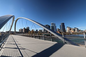
St. Patrick's Island Park is a 31-acre public park on an island at the confluence of the Bow and Elbow rivers just northeast of Downtown Calgary. St. Patrick's Island is one of Calgary's oldest parks. Its development as a public space began in the 1890s, gaining momentum as an important public space in the Calgary inner city with the construction of a bridge to the island in the early 1900s. Throughout the decades, the island has been transformed, playing host to a campground in the 1960s, to being the host of squatters for much of the period from the 1980s to the 2000s. For several decades, the island was connected to Calgary's undesirable East Village neighbourhood by a steel and wooden bridge. However, in the late 2000s the Calgary Municipal Land Corporation began a redevelopment of the East Village, with a particular focus on redeveloping St. Patrick's Island into a full-fledged city park with programmed activities and physical access to the Bow River. After years of construction, the newly redeveloped St. Patrick's Island Park opened to the public in July 2015, along with the new George C. King Bridge which connects the island park with both the East Village to the south and Bridgeland to the north.
Calgary Municipal Land Corporation (CMLC) was incorporated in 2007 as a wholly owned subsidiary of the City of Calgary to implement and execute the Rivers District Community Revitalization Plan – a public infrastructure program approved by the City of Calgary and the Province of Alberta to kick-start Calgary's urban renewal. Since its inception, the CMLC has overseen the development of the East Village, which as of January 2017 has seen CAD $2.7 billion worth of investment since 2010. The CMLC has also been tasked with the redevelopment of Calgary's West Village, Stampede Park, Victoria Park, Olympic Plaza, Arts Commons, and Fort Calgary.