Wildlife
Various wildlife live in the park system, including deer, hawks, owls, rabbits, snakes, fox, coyotes, badgers, porcupines, pelicans, beavers, muskrats, ground squirrels and cranes. [2]
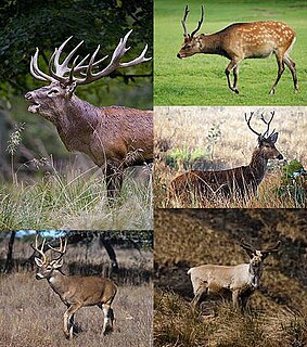
Deer are the hoofed ruminant mammals forming the family Cervidae. The two main groups of deer are the Cervinae, including the muntjac, the elk (wapiti), the fallow deer, and the chital; and the Capreolinae, including the reindeer (caribou), the roe deer, and the moose. Female reindeer, and male deer of all species except the Chinese water deer, grow and shed new antlers each year. In this they differ from permanently horned antelope, which are part of a different family (Bovidae) within the same order of even-toed ungulates (Artiodactyla).
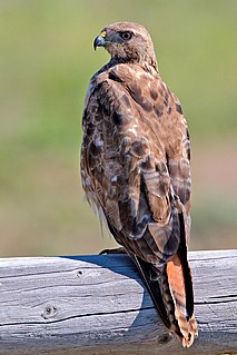
Hawks are a group of medium-sized diurnal birds of prey of the family Accipitridae. Hawks are widely distributed and vary greatly in size.

Owls are birds from the order Strigiformes, which includes about 200 species of mostly solitary and nocturnal birds of prey typified by an upright stance, a large, broad head, binocular vision, binaural hearing, sharp talons, and feathers adapted for silent flight. Exceptions include the diurnal northern hawk-owl and the gregarious burrowing owl.
History
People began to settle in the river valley in the late 19th century, and by 1884, the population was about 250. The next year, many of the families had moved to the prairie level, with more leaving after serious floods in 1902 and 1908. The area was subdivided in 1912, and 83 families settled in the community, which was called Riverside, by the early 1950s. After a serious flood in 1953, Lethbridge City Council moved all the families out of the valley and designated it as parkland recreation. [2]
The Lethbridge City Council is the legislative governing body that represents the citizens of Lethbridge, Alberta. Eight councillors and the mayor comprise the council. The mayor is the city's chief elected official and the city manager is its chief administrative officer. For the 2017–2021 term, the mayor is Chris Spearman and the councillors are Mark Campbell, Jeff Carlson, Jeffrey Coffman, Belinda Crowson, Blaine Hyggen, Joseph Mauro, Rob Miyashiro, and Ryan Parker.
Indian Battle Park had been created by 1960, and the Lethbridge Nature Reserve was established near Indian Battle Park in the mid-1970s. The Lethbridge Naturalists Society and Public School Board built a nature centre in 1980, which was formally opened in 1982 as the Helen Schuler Coulee Centre. [2] This name was changed to the Helen Schuler Nature Centre in 2009. [3]
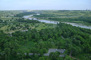
Beginning in 1981, the City of Lethbridge purchased new parkland using funds from Urban Parks for the Future, a project run by the provincial government and funded by the Heritage Trust Fund. Such parks include: Pavan Park, Alexander Wilderness Park, Peenaquim Park, Lethbridge Nature Reserve and Elizabeth Hall Wetlands, Indian Battle Park, Bull Trail Park, Botterill Bottom Park, and Popson Park. [2]
This page is based on this
Wikipedia article Text is available under the
CC BY-SA 4.0 license; additional terms may apply.
Images, videos and audio are available under their respective licenses.

The Maribyrnong River is a perennial river of the Port Phillip catchment, located in the north–western suburbs of Melbourne, in the Australian state of Victoria.

Hluhluwe is a small town in northern KwaZulu-Natal, South Africa. It is situated between iSimangaliso Wetland Park and Hluhluwe–iMfolozi Park on the banks of the Hluhluwe River. Hluhluwe is situated on the elephant coast, an area known for its national parks, natural diversity and cultural heritage. Although relatively undeveloped the area is of growing interest to international tourists and travelers. The area hosted several local and international movie productions including I dreamed of Africa and Ghost Son as well as several documentaries that were filmed in the surrounding national parks.

Bulimba Creek, originally known as Doboy Creek, ia a perennial stream that is a tributary of the Brisbane River, located in suburban Brisbane in the South East region of Queensland, Australia.

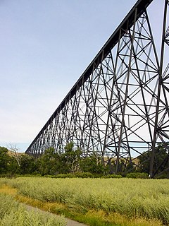
Alberta Provincial Highway No. 3, commonly referred to as Highway 3 and officially named the Crowsnest Highway, is a 324-kilometre (201 mi) highway that traverses southern Alberta, Canada, running from the Crowsnest Pass through Lethbridge to the Trans-Canada Highway in Medicine Hat. Together with British Columbia Highway 3 which begins in Hope, it forms an interprovincial route that serves as an alternate to the Trans-Canada from the Lower Mainland to the Canadian Prairies.

Mullum Mullum Creek is a creek in the outer eastern suburbs of Melbourne, Victoria, Australia. It is the main watercourse of the Mullum Mullum Valley, a tributary of the Yarra River and Yarra Valley. For tens of thousands of years it was used as a food and tool source sustainably by the Wurundjeri people, Indigenous Australians of the Kulin nation, who spoke variations of the Woiwurrung language group.

Darebin Creek is a creek that runs through the northern suburbs of Melbourne, Victoria, Australia. It is the main watercourse of the Darebin Valley and a major tributary of the Yarra River. For tens of thousands of years it was used as a food and tool source sustainably by the Wurundjeri people, Indigenous Australians of the Kulin nation alliance, who spoke variations of the Woiwurrung language group.

Rambynas Regional Park is one of the Regional Parks in Lithuania, situated at Pagėgiai municipality on the right Nemunas river bend in Lithuanian Republic near the border of Kaliningrad Oblast. The park was founded in 1992 with its area of 4,786 ha.
... Life is a constant movement. A Wide variety of different forms emerge and disappear... Over the thousand years, stones grow and decay. Life explodes, animals and people are born and so lost... These days, people learn how to look at nature at more calmed glance. And life effects are clearly visible in a strong relationship with nature as if the person opens the whole mystery of nature, all of the Mysteries...
There are many forms of transport in Lethbridge, Alberta, Canada, including highways and public transit. Lethbridge's airport is Lethbridge County Airport (YQL), which is south of the city boundary. Lethbridge also has an intricate cycling-and-pedestrian pathway that meets several destinations in the city, including the urban park system in the Oldman River valley.

Downtown Lethbridge is the commercial centre of Lethbridge, Alberta, hosting most of the city's banks and several accounting and law practices, including national firms.
West Lethbridge, is one of three geographical areas in Lethbridge, Alberta, Canada. It is the newest and the fastest growing. It is the home of the University of Lethbridge and is a residential area primarily.

The Red Coat Trail is a 1,300-kilometre (810 mi) route that approximates the path taken in 1874 by the North-West Mounted Police in their quest to bring law and order to the Canadian West.

The North Saskatchewan River valley parks system is a continuous collection of urban parks in the North Saskatchewan River valley of Edmonton, Alberta. The parks range from waterside to cliff side to cliff top locations bordering the North Saskatchewan River.

Urban parks in Canada are areas for public recreation and enjoyment or natural preservation in cities in Canada. They are often owned and operated by municipal governments and so are usually called 'municipal parks', and sometimes 'regional parks' depending on the park's features and local government structure.

The Western Sydney Parklands is an urban park system and a nature reserve located in Sydney, New South Wales, Australia. The NSW government has spent around $400 million for the park. The park is governed by the NSW National Parks and Wildlife Service and is listed under the National Parks and Wildlife Act 1974. The Parklands begin in the north in the City of Blacktown, cross the City of Fairfield, and end in the City of Liverpool. The Parkland, being one of the largest in the world, features picnic areas,
sports grounds and walking tracks. The parklands attract 430,000 to 790,000 visitors annually.