
Drumheller is a town on the Red Deer River in the badlands of east-central Alberta, Canada. It is located 110 kilometres (68 mi) northeast of Calgary and 97 kilometres (60 mi) south of Stettler. The Drumheller portion of the Red Deer River valley, often referred to as Dinosaur Valley, has an approximate width of 2 kilometres (1.2 mi) and an approximate length of 28 kilometres (17 mi).
The history of coal mining goes back thousands of years, with early mines documented in ancient China, the Roman Empire and other early historical economies. It became important in the Industrial Revolution of the 19th and 20th centuries, when it was primarily used to power steam engines, heat buildings and generate electricity. Coal mining continues as an important economic activity today, but has begun to decline due to the strong contribution coal plays in global warming and environmental issues, which result in decreasing demand and in some geographies, peak coal.

The National Coal Mining Museum for England is based at the site of Caphouse Colliery in Overton, Wakefield, West Yorkshire, England. It opened in 1988 as the Yorkshire Mining Museum and was granted national status in 1995.

Big Valley is a village in central Alberta, Canada that is southeast of Red Deer. It is located 32 km (20 mi) south of Stettler and 64 km (40 mi) north of Drumheller on Highway 56 in the County of Stettler No. 6.

Morden Colliery Historic Provincial Park is a 4-hectare (9.9-acre) historic provincial park near the east coast of southern Vancouver Island, British Columbia. The location off BC Highway 19 is about 102 kilometres (63 mi) by road northwest of Victoria, and 10 kilometres (6 mi) south of Nanaimo.

Evansburg is a hamlet in west-central Alberta, Canada, within Yellowhead County. It is located on Highway 16A, approximately 88 kilometres (55 mi) west of Edmonton and 96 kilometres (60 mi) east of Edson. The hamlet is adjacent to the Pembina River and the Pembina River Provincial Park.

Nordegg is a hamlet in west-central Alberta, Canada within Clearwater County. It is in the North Saskatchewan River valley in the foothills of the Canadian Rockies, just east of the intersection of the David Thompson Highway and the Highway 734 spur of the Bighorn Highway. A former coal mining town, it was named after Martin Nordegg and the name probably means "North Corner" in a German dialect. The railway station name at the locality was called Brazeau rather than Nordegg at certain points in its history, but the local post office has always been named Nordegg. The name Brazeau is now obsolete.
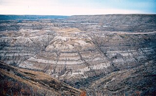
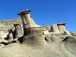
The Horseshoe Canyon Formation is a stratigraphic unit of the Western Canada Sedimentary Basin in southwestern Alberta. It takes its name from Horseshoe Canyon, an area of badlands near Drumheller.

Midland Provincial Park is a provincial park located in Alberta, Canada.

Canmore Museum and Geoscience Centre (CMAGS) is the public name used by the Centennial Museum Society of Canmore. 'Canmore Museum and Geoscience Centre' is the name used by the Centennial Museum Society of Canmore. The Society was incorporated in 1984 under The Societies Act of the Province of Alberta. The society is also a registered charity. In June 2004, the museum moved from its original location to a new purpose built space in the Canmore Civic Centre. Spanning generations, cultures and social classes, the museum presents over 120 years worth of local history.
Provincial historic sites of Alberta are museums and historic sites run by the Government of Alberta.
The Black Diamond Mines Regional Preserve is a 6,000-acre (2,400 ha) park located north of Mount Diablo in Contra Costa County, California under the administration of the East Bay Regional Park District (EBRPD). The district acquired the property in 1973. The preserve contains relics of 3 mining towns, former coal and sand mines, and offers guided tours of a former sand mine. The 60 miles (97 km) of trails in the Preserve cross rolling foothill terrain covered with grassland, California oak woodland, California mixed evergreen forest, and chaparral.
The Galt Historic Railway Park, collects, preserves, restores, exhibits and interprets artifacts which represent the history and social impact of the "steam" era in southern Alberta and the coal era, with emphasis on Galt Railway and the 1890 International Train Station Depot North West Territories from Coutts/Sweetgrass.
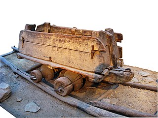
A minecart, mine cart, or mine car is a type of rolling stock found on a mine railway, used for transporting ore and materials procured in the process of traditional mining. Minecarts are seldom used in modern operations, having largely been superseded in underground operations by more efficient belt conveyor systems that allow machines such as longwall shearers and continuous miners to operate at their full capacity, and above ground by large dumpers.

Sego is a ghost town in Grand County, Utah, United States. It lies in the narrow, winding Sego Canyon, in the Book Cliffs some 5 miles (8.0 km) north of Thompson Springs. Formerly an important eastern Utah coal mining town, Sego was inhabited about 1910–1955. The town is accessed via the grade of the Ballard & Thompson Railroad, a spur from the Denver and Rio Grande Western built by the founders of the town to transport the coal.

Chatterley Whitfield Colliery is a disused coal mine on the outskirts of Chell, Staffordshire in Stoke on Trent, England. It was the largest mine working the North Staffordshire Coalfield and was the first colliery in the UK to produce one million tons of saleable coal in a year.
The Reliance Tipple is the site of two coal tipples associated with coal production at Reliance, Wyoming. The first tipple was built in 1910 and used until 1936. The wood structure was built on a sandstone foundation and served Reliance Mines No. 1 through No. 6. The perishable portions of the earlier tipple have disappeared, leaving only the sandstone foundations and some artifacts buried in the tailings pile.
East Coulee is a community within the Town of Drumheller, Alberta, Canada. It was previously a hamlet within the former Municipal District (MD) of Badlands No. 7 prior to the MD's amalgamation with the former City of Drumheller on January 1, 1998. It is also recognized as a designated place by Statistics Canada.

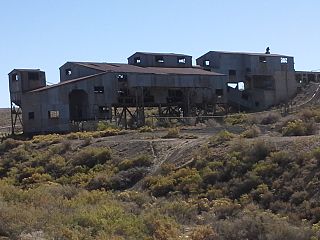
Midlandvale is a community within the Town of Drumheller, Alberta, Canada. It was previously a hamlet within the former Municipal District of Badlands No. 7 prior to being annexed by Drumheller in 1972. Now referred to as Midland by the Town of Drumheller, the community is located within the Red Deer River valley on North Dinosaur Trail, approximately 3 km (1.9 mi) west of Drumheller's main townsite.
Passburg is a ghost town in the Municipality of Crowsnest Pass in southern Alberta, Canada that was formerly a coal mining community. It is on Highway 3 approximately 130 km (81 mi) west of Lethbridge and 4 km (2.5 mi) southeast of Bellevue.


