External links

Coordinates: 55°52′47″N119°12′56″W / 55.87972°N 119.21556°W
| | This Alberta protected areas related article is a stub. You can help Wikipedia by expanding it. |
Moonshine Lake Provincial Park is a provincial park located in Alberta, Canada.
Located 27 km west and 7 km north of Spirit River, on Highway 49.
Coordinates: 55°52′47″N119°12′56″W / 55.87972°N 119.21556°W
| | This Alberta protected areas related article is a stub. You can help Wikipedia by expanding it. |

Bow Valley Provincial Park is a provincial park in Alberta, Canada. Established in 1959 in the arch of the Bow River at its confluence with the Kananaskis River, the park is one park of many within the Kananaskis Country park system.
Calling Lake Provincial Park is a provincial park in Alberta, Canada. It is located 55 km (34 mi) north of Athabasca, 186 km (116 mi) north of Edmonton.

Winagami Lake Provincial Park is a provincial park located in Alberta, Canada. It is located on three sides of the Winagami Lake, and is accessible from Highway 2, 30 km north from High Prairie.
Bearhole Lake Provincial Park is a provincial park in British Columbia, Canada, located 5 km east of the mining community of Tumbler Ridge, on the Alberta Plateau. Established in January 2001, the park includes 12,705 ha of land in the Boreal White and Black Spruce biogeoclimatic zones within the Kiskatinaw Plateau. It is transition zone with mixed wood forests including spruce, pine, and larch. Bearhole Lake, the headwaters of the Kiskatinaw River provides habitat for trumpeter swans, yellow perch, burbot, rainbow trout, and northern pike.
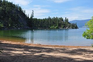
Ellison Provincial Park is a provincial park in British Columbia, Canada, located on the east side of Okanagan Lake to the south of the city of Vernon. The park contains approximately 219 acres (0.89 km2) of land, 200 ha. of it upland, 19 ha. of it foreshore.
Harbour Dudgeon Lakes Provincial Park is a provincial park in British Columbia, Canada, located west of the Adams River, northwest of Celista Mountain. It was established on April 30, 1996. The park is located approximately 175 km northeast of Kamloops.
Momich Lakes Provincial Park is a provincial park in British Columbia, Canada, located at the north end of Adams Lake 100km northeast of Kamloops.
Monte Lake Provincial Park is a provincial park in British Columbia, Canada, located on the east side of Monte Lake and to the south of the community of Monte Lake, British Columbia which is at the north end of the lake. About five hectares in size, it protects an area of Ponderosa pine and grasslands.
Muscovite Lakes Provincial Park is a provincial park in British Columbia, Canada. It is located on the western shore of Lake Williston, 125 km north of Mackenzie.

Pillar Provincial Park is a provincial park in British Columbia, Canada. It is located 11 km (6.8 mi) north of Highway 97 at Falkland. The park area is 2.34 hectares and protects a stone pillar on the hillside above Pillar Lake.

Shuswap Lake Provincial Park is a provincial park in British Columbia, Canada.
Shuswap Lake Marine Provincial Park is a provincial park in British Columbia, Canada, comprising 894 ha. The Park has a variety of amenities including boat launch ramps, picnic areas, and 27 campsites around the perimeter of Shuswap Lake. The lake's name and that of the surrounding Shuswap Country is from the Shuswap people (Secwepemc), the most northern of the Salishan speaking people.

Lac Ste. Anne County is a municipal district in central Alberta, Canada.
Highway 55 is a paved, undivided provincial highway in the Canadian province of Saskatchewan. It runs from the Alberta border west of Pierceland to Highway 9 near Mountain Cabin. Highway 55 is 652 km long. It forms part of the interprovincial Northern Woods and Water Route.
The Kakwa River is a tributary of the Smoky River in western Alberta, Canada.
Big Lake is a lake in Edmonton metropolitan region, Canada. It is located adjacent to the northwest corner of Edmonton and the southwest corner of St. Albert. Its primary inflow is the Sturgeon River. The lake sits on the sands and gravels of the Empress Formation, an aquifer 30 m (98 ft) below its surface that was laid down by retreating glacial meltwaters.
Blueberry Mountain is an unincorporated community in northwestern Alberta in Saddle Hills County, located on Highway 725, 91 kilometres (57 mi) north of Grande Prairie.
Carcajou Pass is a mountain pass on the Continental Divide and British Columbia–Alberta boundary at the north end of Mount Robson Provincial Park. On the Alberta side lies the northwestern part of Jasper National Park. Carcajou is the French word for "wolverine".
Moonshine Lake is a lake in Alberta. As early as 1910, this small lake 55°53′11″N119°13′40″W was located on what was known as the Moonshine Trail. The lake was originally called Mirage Lake. Local folklore tells of two men, Jack Campbell and Harry Hanrahan, who while climbing the steep bank of the north shore of the lake in the 1920s, spilled their home-brewed moonshine. It has been known as Moonshine Lake ever since. There is also folklore that a rich crazy woman buried gold coins at the bottom of the lake. A small find of cold coins routinely washes up on shore periodically.

Lac La Ronge Provincial Park is located in the boreal forest of the north central part of the Canadian province of Saskatchewan within the Canadian Shield. Situated in the Churchill River system, this provincial park has close to 100 lakes and more than 30 canoe routes, many of which follow old fur trade routes. Summer activities include camping, hiking, boating, fishing, and swimming. In the winter, there's cross-country skiing, snowmobiling, and ice fishing. Saskatchewan's highest waterfall is in the park. Nistowiak Falls are located north of Lac La Ronge along the Rapid River.