Sherwood Park is a large hamlet in Alberta, Canada within Strathcona County that is recognized as an urban service area. It is located adjacent to the City of Edmonton's eastern boundary, generally south of Highway 16, west of Highway 21 and north of Highway 630. Other portions of Sherwood Park extend beyond Yellowhead Trail and Wye Road, while Anthony Henday Drive (Highway 216) separates Refinery Row to the west from the balance of the hamlet to the east.

Lac La Biche is a hamlet in Alberta, Canada. The hamlet is the primary service centre for Lac La Biche County, Beaver Lake Cree Nation, Heart Lake First Nation, Kikino Metis Settlement, and Buffalo Lake Metis Settlement with a combined population of over 10,555 (2016) in the greater service area. It is located approximately 220 km (140 mi) northeast of the provincial capital of Edmonton. Previously incorporated as a town, Lac La Biche amalgamated with Lakeland County to form Lac La Biche County on August 1, 2007.

Innisfail-Sylvan Lake is a provincial electoral district in Alberta, Canada. It is one of 87 current districts mandated to return a single member to the Legislative Assembly of Alberta using the first past the post method of voting.

Alberta Provincial Highway No. 16, commonly referred to as Highway 16, is a major east–west highway in central Alberta, Canada, connecting Jasper to Lloydminster via Edmonton. It forms a portion of the Yellowhead Highway, a major interprovincial route of the Trans-Canada Highway system that stretches from Masset, British Columbia to Portage la Prairie, Manitoba, near Winnipeg. Highway 16 spans approximately 634 km (394 mi) from Alberta's border with British Columbia in the west to its border with Saskatchewan in the east. As of 2010, all but less than 96 km (60 mi) of the route was divided, with a minimum of two lanes in each direction. It is designated a core route in Canada's National Highway System.

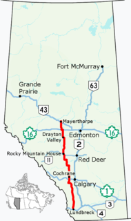
Alberta Provincial Highway No. 22, commonly referred to as Highway 22 and officially named Cowboy Trail, is a 584-kilometre (363 mi) highway in the Canadian province of Alberta. It generally parallels Highway 2, beginning in the foothills of southern Alberta at Highway 3 near Lundbreck Falls. It proceeds north along the eastern slopes of the Rocky Mountains passing through the foothills and ranch country to the aspen parkland of northern Alberta, ending at Highway 18 near Mayerthorpe.

Alberta Provincial Highway No. 1, commonly referred to as Highway 1, is a major east-west highway in southern Alberta, Canada that forms a portion of the Trans-Canada Highway. It runs from the British Columbia border near Lake Louise through Calgary to the Saskatchewan border east of Medicine Hat. It spans approximately 534 km (332 mi) from Alberta's border with British Columbia in the west to its border with Saskatchewan in the east. The route is a divided expressway throughout the province with the exception of a section in central Calgary where it is an arterial thoroughfare. Twinning of the final 8.5 km (5.3 mi) of Highway 1 between Lake Louise and the British Columbia border was completed by Parks Canada and opened to traffic on June 12, 2014.

Alberta Provincial Highway No. 1A is the designation of two alternate routes off the Alberta portion of the Trans-Canada Highway. However, it is not the only name used for spurs off Highway 1 - Highway 1X is another such designation. These highways, however, are not part of the Trans-Canada Highway network, and only have Alberta's provincial primary highway shields instead of the ones used for the Trans-Canada Highway.

Métis in Alberta are Métis people, descendants of mixed First Nations/native Indian and white/European families, who live in the Canadian province of Alberta. The Métis are considered an aboriginal group under Canada's Constitution Act 1982 and make up a separate and distinct from the First Nations, and have different legal rights. In Alberta, unlike in the rest of Canada, Métis people have negotiated certain lands to be reserved for them, known today as the Eight Metis Settlements. These Metis Settlements Federated in 1975 to protect existing Metis Settlement lands following the Alberta Governments dissolution, by Order-In-Council of four Metis Settlements from 1950-1960. Following legal challenges by the Federation of Metis Settlements in 1975 for the lose of natural resource against Alberta, the Crown in Right of Alberta settled out of court for a suite of legislation that would see self-government, land, and money transferred to the newly formed government of the Metis Settlements General Council (MSGC), Canada’s only Metis self-govenernment. The Metis Settlements General Council is the legislator of the Federation of Metis Settlements. MSGC is the second largest land owner in the Province of Alberta.

Chestermere, originally named Chestermere Lake, is a city in the Canadian province of Alberta, within Rocky View County. It is largely a commuter town of Calgary and is a member municipality of the Calgary Regional Partnership. The city, which surrounds Chestermere Lake, was known as Chestermere Lake from 1977 to 1993.

Alberta Provincial Highway No. 11, commonly referred to as Highway 11 and officially named the David Thompson Highway, is a 318-kilometre-long (198 mi) long highway in central Alberta, Canada that connects Red Deer and Sylvan Lake to Highway 93 near Mount Sarbach. It runs from Saskatchewan River Crossing in Banff National Park east through Nordegg, Rocky Mountain House and Red Deer until it connects with Highway 12 near Nevis. The highway is named after David Thompson, a British-Canadian fur trader, surveyor, and map-maker who explored the area between Rocky Mountain House and Kootenae House through Howse Pass.
Cottage country is a common name in the Canadian province of Ontario, as well as other regions of the country, for areas that are popular locations for recreational properties such as cottages and summer homes. Cottage country is often socially, culturally, economically, and politically distinct from other rural areas in that it is populated by a notably higher concentration of urban vacationers and residents who have an affinity for the outdoors in contrast to more traditional rural populations that are largely absent of "city folk". Any major population centre may have its own popular "cottage country" area. The name is sometimes applied locally in vernacular use. For example, Toronto, Ontario residents might say "I am heading up to cottage country this weekend," which is locally understood to be referring to Muskoka, the Kawarthas, or the Haliburton area. On the other hand, a speaker from Ottawa would use the same phrase to denote the Rideau Lakes area or parts of the Outaouais.

The Municipal District of Greenview No. 16 is a municipal district in northwest Alberta, Canada.

Sylvan Lake is a large lake in central Alberta, Canada. The resort town of Sylvan Lake is established on the shores of the lake, west of the city of Red Deer.

Central Alberta is a region located in the Canadian province of Alberta.


