
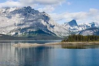
Jasper National Park, in Alberta, Canada, is the largest national park within Alberta's Rocky Mountains, spanning 11,000 km2 (4,200 sq mi). It was established as Jasper Forest Park in 1907, renamed as a national park in 1930, and declared a UNESCO world heritage site in 1984. Its location is north of Banff National Park and west of Edmonton. The park contains the glaciers of the Columbia Icefield, springs, lakes, waterfalls and mountains.

Banff National Park is Canada's first national park, established in 1885 as Rocky Mountains Park. Located in Alberta's Rocky Mountains, 110–180 kilometres (68–112 mi) west of Calgary, Banff encompasses 6,641 square kilometres (2,564 sq mi) of mountainous terrain, with many glaciers and ice fields, dense coniferous forest, and alpine landscapes. Provincial forests and Yoho National Park are neighbours to the west, while Kootenay National Park is located to the south and Kananaskis Country to the southeast. The main commercial centre of the park is the town of Banff, in the Bow River valley.

Kananaskis Country is a multi-use area west of Calgary, Alberta, Canada in the foothills and front ranges of the Canadian Rockies. The area is named for the Kananaskis River, which was named by John Palliser in 1858 after a Cree acquaintance. Covering an area of approximately 4,000 km2 (1,500 sq mi), Kananaskis Country was formed by the Alberta Government in 1978 to provide an assortment of land uses and designations. Land uses include resource extraction activities, recreation, power generation, and residential communities. Land designations include public land and protected areas.

Canmore is a town in Alberta, Canada, located approximately 81 kilometres (50 mi) west of Calgary near the southeast boundary of Banff National Park. It is located in the Bow Valley within Alberta's Rocky Mountains. The town shares a border with Kananaskis Country to the west and south and the Municipal District of Bighorn No. 8 to the north and east. With a population of 17,036 in 2023, Canmore is the fifth-largest town in Alberta.

Anûkathâ Îpa is an outlier of Mount Charles Stewart in the Canadian Rockies of Alberta. It is one of the most prominent landmarks in the vicinity of Canmore, Alberta.

Mount Rundle is a mountain in Canada's Banff National Park overlooking the towns of Banff and Canmore, Alberta. The Cree name was Waskahigan Watchi or house mountain. In 1858 John Palliser renamed the mountain after Reverend Robert Rundle, a Methodist invited by the Hudson's Bay Company to do missionary work in western Canada in the 1840s. He introduced syllabics there—a written language developed for the Cree, as part of his missionary work. He only visited the Stoney-Nakoda of the area around what is now called Mount Rundle in 1844 and 1847.
Highway 1 is a major east–west highway in southern Alberta that forms the southern mainline of the Trans-Canada Highway. It runs from the British Columbia border near Lake Louise through Calgary to the Saskatchewan border east of Medicine Hat. It continues as Highway 1 into both provinces. It spans approximately 534 km (332 mi) from Alberta's border with British Columbia in the west to its border with Saskatchewan in the east. Highway 1 is designated as a core route in Canada's National Highway System and is a core part of the developing Alberta Freeway Network.
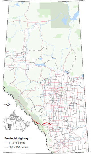
Highway 1A is the designation of two alternate routes off the Alberta portion of Trans-Canada Highway 1. However, it is not the only name used for spurs off Highway 1 - Highway 1X is another such designation. Despite these highways being suffixed routes of Highway 1, they are not part of the Trans-Canada Highway network, and are signed with Alberta's provincial primary highway shields instead of the Trans-Canada shields used for Highway 1.

Bow Valley Provincial Park is a provincial park in Alberta, Canada. Established in 1959 in the arch of the Bow River at its confluence with the Kananaskis River, the park is one park of many within the Kananaskis Country park system.
Peter Lougheed Provincial Park is in Kananaskis Country about 90 kilometres (56 mi) west of Calgary, along the Kananaskis Trail in Alberta, Canada.
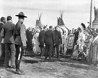
The Nakoda are an Indigenous people in Western Canada and the United States.

Stoney 142, 143, 144 is an Indian reserve of the Stoney Nakoda First Nation, comprising Bearspaw, Chiniki, and Wesley First Nations in Alberta, located between the Municipal District of Bighorn No. 8 and Rocky View County. The largest community of the Nakoda people, it is 56 kilometers west of Calgary.

Tunnel Mountain, also known as Sleeping Buffalo, is a mountain located in the Bow River Valley of Banff National Park in Alberta, Canada at the junction of the Spray River with the Bow and overlooking the Hot Springs on Sulphur Mountain. The mountain is nearly completely encircled by the town of Banff and the Banff Springs Hotel grounds. For many Indigenous people, the Buffalo is not sleeping anymore since Banff National Park reintroduced wild bison in 2017.
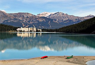
Lake Louise is a glacial lake within Banff National Park in Alberta, Canada. Situated 11 km (6.8 mi) east of the border with British Columbia, Lake Louise is located 5 km (3.1 mi) west of the hamlet of Lake Louise and the Trans-Canada Highway.

Mount Lawrence Grassi is the tallest peak of the Ehagay Nakoda massif, a multi-peaked mountain located immediately south of the town of Canmore just east of the Spray Lakes road in Alberta's Canadian Rockies. The mountain sports two other subsidiary peaks with commemorative names: Ha Ling Peak on the northwestern end, and Miners Peak located southeast of Ha Ling Peak between Ha Ling Peak and Mount Lawrence Grassi. Another peak on the mountain is named Ship's Prow, which is on the Southeastern end of the mountain. The mountain is separated from Mount Rundle by Whiteman's Gap, and is separated to the South from The Three Sisters by Three Sisters Pass.

Banff-Kananaskis is a provincial electoral district in Alberta, Canada. The district is one of 87 districts mandated to return a single member (MLA) to the Legislative Assembly of Alberta using the first past the post method of voting. It was contested for the first time in the 2019 Alberta election.
Miranda Rosin is a Canadian politician who represented the electoral district of Banff-Kananaskis in the Legislative Assembly of Alberta for the United Conservative Party from 2019 to 2023.

Ehagay Nakoda is a multipeaked massif located immediately south of the town of Canmore just east of the Spray Lakes road in Alberta's Canadian Rockies. The mountain sports two subsidiary peaks with commemorative names, Mount Lawrence Grassi and Ha Ling Peak on the northwestern end. It also sports two other named peaks: Ship's Prow on the southeastern side, and Miners Peak. The mountain is separated from Mount Rundle by Whiteman's Gap, and is separated to the South from The Three Sisters by Three Sisters Pass.
The Rocky Mountain Outlook is a weekly local newspaper based in Canmore, Alberta, Canada. The Rocky Mountain Outlook is delivered across the Bow Valley in Banff, Canmore, Lake Louise, the Municipal District of Bighorn and the Stoney Nakoda First Nation. The paper covers news in and around the Bow Valley region, which spans from Lake Louise in the west to the Stoney Nakoda First Nation and Kananaskis Country in the east. The paper does not charge readers and relies on advertising for income.
Don Getty Wildland Provincial Park is a wildland provincial park in Kananaskis Country, Alberta, Canada. It was created on 24 July 2001 and has an area of 62,775 hectares. The park was named for the 11th premier of Alberta, Don Getty. The park was designated as part of the Special Places 2000: Alberta’s Natural Heritage initiative.


