
The Continental Divide of the Americas is the principal, and largely mountainous, hydrological divide of the Americas. The Continental Divide extends from the Bering Strait to the Strait of Magellan, and separates the watersheds that drain into the Pacific Ocean from those river systems that drain into the Atlantic and Arctic oceans.
Yoho National Park is a national park of Canada. It is located within the Rocky Mountains along the western slope of the Continental Divide of the Americas in southeastern British Columbia, bordered by Kootenay National Park to the south and Banff National Park to the east in Alberta. The word Yoho is a Cree expression of amazement or awe, and it is an apt description for the park's spectacular landscape of massive ice fields and mountain peaks, which rank among the highest in the Canadian Rockies.

Banff National Park is Canada's oldest national park, established in 1885 as Rocky Mountains Park. Located in Alberta's Rocky Mountains, 110–180 kilometres (68–112 mi) west of Calgary, Banff encompasses 6,641 square kilometres (2,564 sq mi) of mountainous terrain, with many glaciers and ice fields, dense coniferous forest, and alpine landscapes. The Icefields Parkway extends from Lake Louise, connecting to Jasper National Park in the north. Provincial forests and Yoho National Park are neighbours to the west, while Kootenay National Park is located to the south and Kananaskis Country to the southeast. The main commercial centre of the park is the town of Banff, in the Bow River valley.

The Canadian Rocky Mountain Parks World Heritage Site is located in the Canadian Rockies. It consists of seven contiguous parks including four national parks:

The South Saskatchewan River is a major river in Canada that flows through the provinces of Alberta and Saskatchewan.

The Canadian Rockies or Canadian Rocky Mountains, comprising both the Alberta Rockies and the B.C. Rockies, is the Canadian segment of the North American Rocky Mountains. It is the easternmost part of the Canadian Cordillera, which is the northern segment of the North American Cordillera, the expansive system of interconnected mountain ranges between the Interior Plains and the Pacific Coast that runs northwest–southeast from central Alaska to the Isthmus of Tehuantepec in Mexico.

Kootenay National Park is a national park of Canada located in southeastern British Columbia. The park consists of 1,406 km2 (543 sq mi) of the Canadian Rockies, including parts of the Kootenay and Park mountain ranges, the Kootenay River and the entirety of the Vermilion River. While the Vermilion River is completely contained within the park, the Kootenay River has its headwaters just outside the park boundary, flowing through the park into the Rocky Mountain Trench and eventually joining the Columbia River. The park ranges in elevation from 918 m (3,012 ft) at the southwestern park entrance to 3,424 m (11,234 ft) at Deltaform Mountain.

The Kicking Horse River is in the Canadian Rockies of southeastern British Columbia, Canada. The river was named in 1858, when James Hector, a member of the Palliser Expedition, reported being kicked by his packhorse while exploring the river. Hector named the river and the associated pass as a result of the incident. The Kicking Horse Pass, which connects through the Rockies to the valley of the Bow River, was the route through the mountains subsequently taken by the Canadian Pacific Railway when it was constructed during the 1880s. The railway's Big Hill and associated Spiral Tunnels are in the Kicking Horse valley and were necessitated by the steep rate of descent of the river and its valley.

Clearwater is a river of southern Alberta, Canada. Situated entirely in the Canadian Rockies and the Rocky Mountain foothills of Alberta, it is a glacier fed upper reach tributary of the North Saskatchewan River. The upper reach of the Clearwater has become popular for equestrian travelers due to the natural setting along the river.

Howse Pass is a pass through the Rocky Mountains in Canada. The pass is located in Banff National Park, between Mount Conway and Howse Peak. From here waters flow east via Conway Creek, Howse River, North Saskatchewan River to Lake Winnipeg and Hudson Bay. To the west it drains by the Blaeberry River to the Columbia River and on to the Pacific Ocean.

Hamber Provincial Park is a provincial park in British Columbia, Canada, located 130 kilometres (80.7 mi) north of Golden. Straddling the Great Divide on the provincial boundary with Alberta, the park is surrounded on three sides by Jasper National Park and protects the headwaters of the Wood River at Fortress Lake.
The Waputik Range lies west of the upper Bow Valley, east of Bath Creek, and south of Balfour Creek in the Canadian Rockies. "Waputik" means "white goat" in Stoney. The range was named in 1884 by George Mercer Dawson of the Geological Survey of Canada. The President Range lies within the Waputik Range.

The Waputik Icefield is located on the Continental divide in the Canadian Rocky Mountains, in the provinces of British Columbia and Alberta. It is developed on the heights of the Waputik Range in the Central Main Ranges.

The Brazeau River is a river in western Alberta, Canada. It is a major tributary of the North Saskatchewan River.
Simpson Pass, el. 2,107 m (6,913 ft), is a mountain pass on the border between the Canadian provinces of Alberta and British Columbia, in the area of the Ball Range. It is the prominence col for Mount Ball on the Continental Divide in the vicinity of Sunshine Village ski resort. Simpson River and Simpson Pass are named after Sir George Simpson who first explored the area in 1841.
The Palliser Formation is a stratigraphic unit of Late Devonian (Famennian) age in the Western Canada Sedimentary Basin. It is a thick sequence of limestone and dolomitic limestone that is present in the Canadian Rockies and foothills of western Alberta. Tall cliffs formed of the Palliser Formation can be seen throughout Banff and Jasper National Parks.
The Waputik Mountains are a mountain range of the Canadian Rockies, located on the Continental Divide between Banff and Yoho National Park. Covering an area of 1,069 square kilometres (413 sq mi), the range is located west of the Howse, Blaeberry and Amiskwi Rivers and east of the Bow and Mistaya Rivers and south to Kicking Horse Pass. Named in 1884 by George M. Dawson, "waputik" is the Stoney Indian word for white goat.

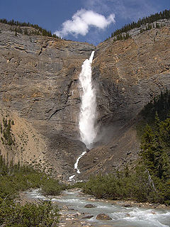
Mount Niles is a 2,967-metre (9,734-foot) summit located in the Waputik Range of Yoho National Park, in the Canadian Rockies of British Columbia, Canada. Its nearest higher peak is Mount Daly, 1.63 km (1.01 mi) to the immediate northeast. Takakkaw Falls is situated four km to the west, the Waputik Icefield lies to the north, and Sherbrooke Lake lies to the south.