Related Research Articles

Williston Lake is a reservoir created by the W. A. C. Bennett Dam and is located in the Northern Interior of British Columbia, Canada.
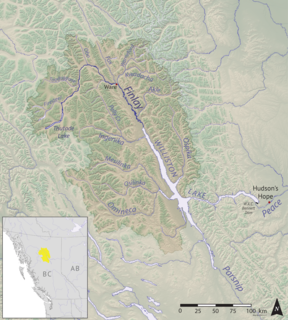
The Finlay River is a 402 km long river in north-central British Columbia flowing north and thence south from Thutade Lake in the Omineca Mountains to Williston Lake, the impounded waters of the Peace River formed by the completion of the W.A.C. Bennett Dam in 1968. Prior to this, the Finlay joined with the Parsnip River to form the Peace. The headwaters of the Finlay at Thutade Lake are considered the ultimate source of the Mackenzie River. Deserters Canyon is located just north of Williston Lake.
The Parsnip River is a 240-kilometre (150 mi) long river in central British Columbia, Canada. It flows generally north-westward from the Parsnip Glacier in the Hart Ranges to the Parsnip Reach of Williston Lake, formed by the impounding of the waters of the Peace River by the W.A.C. Bennett Dam in 1968. Prior to that, the Parsnip joined with the Finlay River to form the Peace at Finlay Forks, with both sharing an alignment along the Rocky Mountain Trench.
Elk Falls Provincial Park is a provincial park in British Columbia, Canada. It is 1,807 hectares in size and is located at the east end of John Hart Lake on the northwest side of the city of Campbell River, on Vancouver Island.
The Squamish Nation, Sḵwx̱wú7mesh Úxwumixw in Sḵwx̱wú7mesh Sníchim, is an Indian Act government originally imposed on the Squamish (Sḵwx̱wú7mesh) by the Federal Government of Canada in the late 19th century. The Squamish are Indigenous to British Columbia, Canada. Their band government comprises 16 elected councillors, serving four-year terms, with an elected band manager. Their main reserves are near the town of Squamish, British Columbia and around the mouths of the Capilano River, Mosquito Creek, and Seymour River on the north shore of Burrard Inlet in North Vancouver, British Columbia.
The Spallumcheen Indian Band, also called the Splats'in First Nations is a member of the Secwepemc (Shuswap) Nation, located in the Central Interior region of the Canadian province of British Columbia. Its main Indian reserve is located at Enderby, British Columbia. It was created when the government of the then-Colony of British Columbia established an Indian Reserve system in the 1860s. It is a member government of the Shuswap Nation Tribal Council.
The Williams Lake First Nation is a First Nations government of the Secwepemc (Shuswap) Nation, located in the Cariboo region of the Central Interior region of the Canadian province of British Columbia, at the city of Williams Lake. It was created when the government of the then-Colony of British Columbia established an Indian Reserve system in the 1860s. It is a member government of the Northern Shuswap Tribal Council. Its main Indian Reserve is Williams Lake Indian Reserve No. 1, a.k.a. "Sugarcane" or "The Cane" or "SCB".
The Ashcroft First Nation is a First Nations government Thompson Canyon area of the Central Interior of the Canadian province of British Columbia. Its Indian Reserves are located near the town of Ashcroft, British Columbia, it is a member of the Nlaka'pamux Nation Tribal Council.
The Red Bluff First Nation is a Dakelh First Nations government located in the northern Fraser Canyon region of the Canadian province of British Columbia. It is a member of the Carrier-Chilcotin Tribal Council, which includes both Tsilhqot'in and Carrier (Dakelh) communities.
The Tŝideldel First Nation is the band government of the Tsi Del Del subgroup of the Tsilhqot'in people, located in the Chilcotin District in the western Central Interior region of the Canadian province of British Columbia. It is a member of the Tsilhqot'in National Government.
The Stone First Nation or Yunesit'in First Nation is a band government of the Yunesit'in subgroup of the Tsilhqot'in people, whose territory is the Chilcotin District in the western Central Interior region of the Canadian province of British Columbia. It is a member of the Tsilhqot'in Tribal Council. The people of the Stone First Nation are known as the Yunesit'in in the Chilcotin language.
The Tl'etinqox-t'in Government Office is a First Nations government located in the Chilcotin District in the western Central Interior region of the Canadian province of British Columbia. Governing a reserve communities near Alexis Creek known as Anaham Reserve First Nations or Anaham, it is a member of the Tsilhqot'in Tribal Council aka known as the Tsilhqot'in National Government. The main reserve is officially known as Anahim's Flat No. 1, and is more commonly as Anaham. Other reserves are Anahim's Meadow No. 2 and 2A, and Anahim Indian Reserves Nos. 3 through 18. Anaham, or Anahim and Alexis were chiefs of the Tsilhqot'in during the Chilcotin War of 1864, although they and their people did not take part in the hostilities.
Deserters Canyon is a canyon on the Finlay River in the Northern Interior of British Columbia, Canada. It is located just upstream (north) from the head of the Finlay Arm of Lake Williston, the reservoir created by WAC Bennett Dam on the lower Peace River.
The Nazko First Nation is a First Nations government of the Dakelh people in the north-central Interior of British Columbia. Its reserves are located around the community of Nazko, British Columbia, which is 120 km west of Quesnel and southwest of Prince George.
The Firesteel River is the uppermost left tributary of the Finlay River in the Northern Interior of British Columbia, Canada. The river originates at Tatlatui Lake, while the Finlay originates at the outlet of Thutade Lake, to the southeast, which is considered the ultimate source of the Mackenzie River.
The Scowlitz First Nation or Scowlitz Indian Band is the band government of Skaulits subgroup of the Stó:lō people located on Harrison Bay in the Upper Fraser Valley region between Chehalis (E) and Lake Errock, British Columbia, Canada (W). They are a member government of the Stó:lō Tribal Council.
The Sustut River is a major tributary of the Skeena River in the north-central Interior of British Columbia, Canada. It forms the northwest boundary of the Hogem Ranges and flows southwest to meet the Skeena, north of Hazelton. Originally named the Bear Wallow River, its headwaters are at Sustut Lake, northwest of Germansen Landing.
The extreme points of British Columbia are four in number:

The Tsay Keh Dene First Nation is one of the Sekani bands of the Northern Interior of British Columbia. Tsay Keh Dene means "People of the Mountain". While they have an office in the City of Prince George, their territories, settlements, and Indian Reserves are all to the north, in the area of Williston Lake.
References
Coordinates: 56°19′00″N123°57′00″W / 56.31667°N 123.95000°W