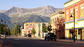
Fernie is a city in the Elk Valley area of the East Kootenay region of southeastern British Columbia, Canada, located on BC Highway 3 on the western approaches to the Crowsnest Pass through the Rocky Mountains. Founded in 1898 and incorporated as the City of Fernie in July 1904, the municipality has a population of over 5,000 with an additional 2,000 outside city limits in communities under the jurisdiction of the Regional District of East Kootenay. A substantial seasonal population swells the city during the winter months.

Lake Koocanusa is a reservoir in British Columbia (Canada) and Montana formed by the damming of the Kootenai River by the Libby Dam in 1972. The Dam was formally dedicated by President Gerald Ford on August 24, 1975.

The Elk River is a 220-kilometre (140 mi) long river, in the southeastern Kootenay district of the Canadian province of British Columbia. Its drainage basin is 4,450 square kilometres (1,720 sq mi) in area. Its mean discharge is approximately 60 cubic metres per second (2,100 cu ft/s), with a maximum recorded discharge of 818 cubic metres per second (28,900 cu ft/s). It is a tributary of the Kootenay River, and falls within the basin of the Columbia River.

The Kootenay River or Kootenai River is a major river of the Northwest Plateau in southeastern British Columbia, Canada, and northern Montana and Idaho in the United States. It is one of the uppermost major tributaries of the Columbia River, the largest North American river that empties into the Pacific Ocean. The Kootenay River runs 781 kilometres (485 mi) from its headwaters in the Kootenay Ranges of the Canadian Rockies, flowing from British Columbia's East Kootenay region into northwestern Montana, then west into the northernmost Idaho Panhandle and returning to British Columbia in the West Kootenay region, where it joins the Columbia at Castlegar.

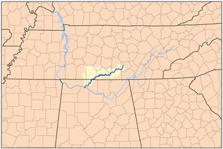
The Elk River is a tributary of the Tennessee River in the U.S. states of Tennessee and Alabama. The river is about 195 miles (314 km) long.

The Regional District of East Kootenay (RDEK) is a regional district in the Canadian province of British Columbia, Canada. In the 2016 census, the population was 60,439. Its area is 27,542.69 km2 (10,634.29 sq mi). The regional district offices are in Cranbrook, the largest community in the region. Other important population centres include the cities of Kimberley and Fernie, and the district municipality of Invermere and Sparwood. Despite its name, the regional district does not include all of the region known as the East Kootenay, which includes the Creston Valley and the east shore of Kootenay Lake.
The Stuart River or Nak'alkoh is one of the largest tributaries of the Nechako River in northeastern British Columbia, Canada. The Nechako is in turn one the more important tributaries of the Fraser River. The Stuart River flows 187 kilometres (116 mi) from Stuart Lake to its junction with the Nechako River. The river drains a portion of the Nechako Plateau—a gently-rolling region characterized by small lakes and tributaries. Low but impressive ridges interact with the river, creating high bluffs and hoodoos.
Elkford is a district municipality in the southeast region of the Canadian province of British Columbia in the Rocky Mountain range. It is 32 km (20 mi) north of the junction at Sparwood, on provincial Highway 43. Outdoor recreational activities take place in Elkford throughout the year. Elkford hosts an annual festival called Wildcat Days during the last weekend of June.

The Wapiti River is a river in eastern British Columbia and western Alberta, Canada. It is a major tributary of the Smoky River, located in the southern area of the Peace River Basin.
Rice Creek might refer to:

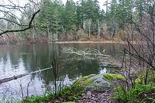
The Elk/Beaver Regional Park is a 1,072-acre (434 ha) park in Saanich, British Columbia, containing Elk Lake and Beaver Lake.
The Wigwam River is a tributary of the Elk River that flows through the U.S. state of Montana and the Canadian province of British Columbia. It is part of the Columbia River basin, as the Elk River is a tributary of the Kootenay River, which is a tributary of the Columbia.

The Elk Point Group is a stratigraphic unit of Early to Middle Devonian age in the Western Canada and Williston sedimentary basins. It underlies a large area that extends from the southern boundary of the Northwest Territories in Canada to North Dakota in the United States. It has been subdivided into numerous formations, number of which host major petroleum and natural gas reservoirs.
Lizard Creek is a tributary of the Elk River. Their confluence is south of the city of Fernie, British Columbia near the base of Fernie Alpine Resort. Lizard Creek drains a side valley of the Elk Valley called Cedar Valley, which is home to Island Lake Lodge.

San Juan River is a river that flows from east to west through southern Vancouver Island in British Columbia, Canada. The river originates in the Seymour Range, flows westward through the San Juan Valley to Port San Juan at Port Renfrew.

Elk Run is a tributary of West Branch Fishing Creek in Sullivan County and Columbia County, in Pennsylvania. It is approximately 4.8 miles (7.7 km) long and flows through Davidson Township in Sullivan County and Sugarloaf Township in Columbia County. The watershed of the stream has an area of 7.49 square miles (19.4 km2). The stream has three named tributaries: Gallows Run, Hog Run, and Long Run. Elk Run is considered to be an Exceptional Value stream and a Migratory Fishery. The forests surrounding it are deemed by the Sullivan County Natural Areas Inventory to be a "locally significant" area. The stream is named for an elk that was killed in it in the 1840s.

Upper Campbell Lake is a reservoir on Vancouver Island in British Columbia, Canada. The lake was flooded in 1958 for a large hydroelectric project, which raised the water level by 30 metres (98 ft). Crest Creek and headwaters of the Heber River are diverted into the lake. Part of the lake and its watershed is located in Strathcona Provincial Park, and the Strathcona Park Lodge is located on the eastern side. Freshwater fish species in the lake include Cutthroat trout, Rainbow trout and Dolly varden.


