
Grande Prairie is a city in northwest Alberta, Canada within the southern portion of an area known as Peace River Country. It is located at the intersection of Highway 43 and Highway 40, approximately 456 km (283 mi) northwest of Edmonton. The city is surrounded by the County of Grande Prairie No. 1.

Willmore Wilderness Park, located in Alberta, Canada, is a 4,600 square kilometres (1,800 sq mi) wilderness area adjacent to the world-famous Jasper National Park. It is lesser known and less visited than Jasper National Park. There are no public roads, bridges or buildings. There are, however, several ranger cabins in the park that are available as a courtesy to visitors.

The Peace River is a 1,923-kilometre-long (1,195 mi) river in Canada that originates in the Rocky Mountains of northern British Columbia and flows to the northeast through northern Alberta. The Peace River joins the Athabasca River in the Peace-Athabasca Delta to form the Slave River, a tributary of the Mackenzie River. The Finlay River, the main headwater of the Peace River, is regarded as the ultimate source of the Mackenzie River. The combined Finlay–Peace–Slave–Mackenzie river system is the 13th longest river system in the world.

Northern Alberta Railways was a Canadian railway which served northern Alberta and northeastern British Columbia. Jointly owned by both Canadian National Railway and Canadian Pacific Railway, NAR existed as a separate company from 1929 until 1981.

Dunvegan-Central Peace was a provincial electoral district in Alberta, Canada mandated to return a single member to the Legislative Assembly of Alberta using the first-past-the-post method of voting from 2004 to 2012.

Grande Prairie-Wapiti is provincial electoral district in northwestern Alberta, Canada. It is one of 87 mandated to return a single member to the Legislative Assembly of Alberta using the first past the post method of voting.

The Peace River Country is an aspen parkland region centring on the Peace River in Canada. It extends from northwestern Alberta to the Rocky Mountains in northeastern British Columbia, where a certain portion of the region is also referred to as the Peace River Block.
Alberta Provincial Highway No. 43, commonly referred to as Highway 43, is a major highway in northern and central Alberta, Canada that connects Edmonton to the British Columbia border via the Peace Country, forming the northernmost portion of the CANAMEX Corridor in Alberta. It stretches approximately 495 km (308 mi) from Highway 16 near Manly Corner west of Edmonton to the British Columbia border west of Demmitt. It is designated as a core route in Canada's National Highway System, comprising a portion of a key international corridor that stretches from Alaska into Mexico.

The North Saskatchewan River is a glacier-fed river that flows from the Canadian Rockies continental divide east to central Saskatchewan, where it joins with the South Saskatchewan River to make up the Saskatchewan River. Its water flows eventually into the Hudson Bay.

The Municipal District of Greenview No. 16 is a municipal district in northwest Alberta, Canada.

The Smoky River is a river in western Alberta, Canada. It is a major tributary of the Peace River. The descriptive name refers to the presence of "smouldering beds of coal in the riverbank" noted by the Cree Indians.

The Little Smoky River is a tributary of the Smoky River in west-central Alberta, Canada.

Northern Alberta is a region located in the Canadian province of Alberta.

Kiskatinaw is a tributary of the Peace River in northeastern British Columbia, Canada.
The Kakwa River is a tributary of the Smoky River in western Alberta, Canada.

The Smoky Group is a stratigraphical unit of Late Cretaceous age in the Western Canadian Sedimentary Basin.
The Wapiti Group is a stratigraphical unit of Cretaceous age in the Western Canadian Sedimentary Basin. It has formation status in Alberta and group status in British Columbia.

The Redwillow River is a tributary of the Wapiti River in northern Alberta and north-eastern British Columbia, Canada. It flows through the Pouce Coupe Prairie, in the south of Peace River Country.
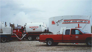
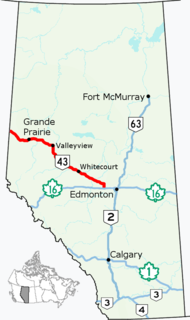
Peace Pipe Line Ltd. was a pipeline company that operated in the Canadian provinces of Alberta and British Columbia. The pipeline's headquarters were in Calgary, Alberta, with division offices in Valleyview, Alberta, Grande Prairie, Alberta, Whitecourt, Alberta and Dawson Creek, BC and the control centre was located in Edmonton, Alberta. The Peace Pipe Line, its subsidiaries; Pouce Coupe and Plateau, were in part, predecessors of today's Pembina Pipeline Corporation.

Central Peace-Notley is a provincial electoral district in Alberta, Canada. The district was one of 87 districts mandated to return a single member (MLA) to the Legislative Assembly of Alberta using the first past the post method of voting. It was contested for the first time in the 2019 Alberta election.


