
The Crowsnest Highway is an east-west highway in British Columbia and Alberta, Canada. It stretches 1,161 km (721 mi) across the southern portions of both provinces, from Hope, British Columbia to Medicine Hat, Alberta, providing the shortest highway connection between the Lower Mainland and southeast Alberta through the Canadian Rockies. Mostly two-lane, the highway was officially designated in 1932, mainly following a mid-19th-century gold rush trail originally traced out by an engineer named Edgar Dewdney. It takes its name from the Crowsnest Pass, the location at which the highway crosses the Continental Divide between British Columbia and Alberta.
Highway 93 is a north–south route through the southeastern part of British Columbia, in the Regional District of East Kootenay and takes its number from U.S. Highway 93 that it connects with at the Canada–United States border. It follows the Crowsnest Highway (Highway 3) and Highway 95 through Radium Hot Springs and to where it crosses the Continental Divide into Alberta at Vermilion Pass, where it continues as Alberta Highway 93. The section between the Canada-U.S. border and the Crowsnest Highway is known as the Elko–Roosville Highway, the section between the Crowsnest Highway and Radium Hot Springs is known as the Kootenay–Columbia Highway, while the section east of Radium Hot Springs is known as the Banff–Windermere Parkway.

Alberta Provincial Highway No. 3, commonly referred to as Highway 3 and officially named the Crowsnest Highway, is a 324-kilometre (201 mi) highway that traverses southern Alberta, Canada, running from the Crowsnest Pass through Lethbridge to the Trans-Canada Highway in Medicine Hat. Together with British Columbia Highway 3 which begins in Hope, it forms an interprovincial route that serves as an alternate to the Trans-Canada from the Lower Mainland to the Canadian Prairies.

Elbow Falls is a small set of waterfalls along the Elbow River, west of the hamlet of Bragg Creek within Kananaskis Improvement District, Alberta. They are located along Highway 66, 20 km (12 mi) west of the Bragg Creek turnoff on Highway 22.
Alberta Provincial Highway No. 22, commonly referred to as Highway 22 and officially named Cowboy Trail, is a 584-kilometre (363 mi) highway in the Canadian province of Alberta. It generally parallels Highway 2, beginning in the foothills of southern Alberta at Highway 3 near Lundbreck Falls. It proceeds north along the eastern slopes of the Rocky Mountains passing through the foothills and ranch country to the aspen parkland of northern Alberta, ending at Highway 18 near Mayerthorpe.

Alberta Provincial Highway No. 4, commonly referred to as Highway 4, is a 103-kilometre (64 mi) highway in southern Alberta, Canada that connects Highway 3 in Lethbridge to Interstate 15 in Montana. The highway was designated in 1999 as the First Special Service Force Memorial Highway in honour of elite soldiers who travelled to Helena, Montana for training before World War II. The highway continues on into America retaining that designation.

Alberta Provincial Highway No. 21, commonly referred to as Highway 21, is a north-south highway in Alberta, Canada that parallels Highway 2 between Calgary and Edmonton. It is approximately 328 kilometres (204 mi) in length. It begins at the Trans-Canada Highway (Highway 1) east of Strathmore, and ends at Fort Saskatchewan where it is succeeded by Highway 15. The northernmost 25 kilometres (16 mi) of the highway are twinned. Highway 21 runs roughly parallel to the main north-south CN rail line between Calgary and Edmonton between Three Hills and Looma.

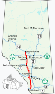
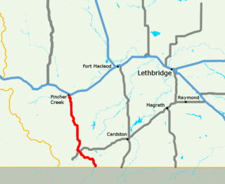
Alberta Provincial Highway No. 5, commonly referred to as Highway 5, is a 129-kilometre (80 mi) highway that connects Lethbridge to Waterton Lakes National Park in southern Alberta, Canada. It begins as an east–west highway in Waterton and transitions to a north–south route before ending at Crowsnest Trail (Highway 3) in Lethbridge.
Alberta Provincial Highway No. 6, commonly referred to as Highway 6, is a north-south highway in southern Alberta, Canada. It spans approximately 74 kilometres (46 mi) from Alberta's border with Montana to Highway 3.

Highway 17 is a highway in Canada that straddles and criss-crosses the Alberta–Saskatchewan provincial border. The portion from the provincial border at Dillberry Lake Provincial Park to the provincial border 800 metres (2,600 ft) north of the North Saskatchewan River is designated as Alberta Provincial Highway No. 17 by Alberta Transportation, commonly referred to as Highway 17.

Alberta Provincial Highway No. 23, commonly referred to as Highway 23, is a highway in southern Alberta, Canada, east of Highway 2 that serves as an alternate route between Calgary and Lethbridge.

Alberta Provincial Highway No. 40, commonly referred to as Highway 40, is a south-north highway in western Alberta, Canada. It is also named Bighorn Highway and Kananaskis Trail in Kananaskis Country. Its segmented sections extend from Coleman in the Municipality of Crowsnest Pass northward to the City of Grande Prairie and is currently divided into four sections.

Alberta Provincial Highway No. 66, commonly referred to as Highway 66, is an east–west highway in central Alberta, Canada. In the east, Highway 66 begins at an intersection with Highways 22 and 762 south of the Hamlet of Bragg Creek and ends 28 km (17 mi) to the west at the Little Elbow Recreation Area. The highway provides access to the Easter Seals Camp Horizon and Elbow Falls.
Alberta Provincial Highway No. 734, commonly referred to as Highway 734, is a highway in western Alberta, Canada that travels through the forested foothills of the Rocky Mountains. It used to be part of Forestry Trunk Road and is still colloquially referred to as such.

Cypress County is a municipal district in southeastern Alberta, Canada. The County completely surrounds the City of Medicine Hat and the Town of Redcliff. The municipality is part of Census Division 1, Alberta. The first farm in the area was settled in 1890.

Alberta Provincial Highway No. 666, commonly referred to as Highway 666, is a highway in the province of Alberta, Canada. It runs mostly west-east, on mostly existing township and range roads in the Municipal District of Greenview No. 16 in Northern Alberta, for 37 km.
Alberta Provincial Highway No. 3A, commonly referred to as Highway 3A, is the designation of four alternate routes of Highway 3 in southern Alberta, Canada. All four segments are former alignments of Highway 3, also known as the Crowsnest Highway.

The Red Coat Trail is a 1,300-kilometre (810 mi) route that approximates the path taken in 1874 by the North-West Mounted Police as they moved through the Canadian West.
British Columbia Highway 3, officially named the Crowsnest Highway, is an 841-kilometre (523 mi) highway that traverses southern British Columbia, Canada. It runs from the Trans-Canada Highway (Highway 1) at Hope to Crowsnest Pass at the Alberta border and forms the western portion of the interprovincial Crowsnest Highway that runs from Hope to Medicine Hat, Alberta. The highway is considered a Core Route of the National Highway System.

Lundbreck is a hamlet in southern Alberta, Canada within the Municipal District of Pincher Creek No. 9. It is located on the south side of Highway 3, approximately 3 kilometres (1.9 mi) east of the southern terminus of Highway 22, 16 km (9.9 mi) east of the Municipality of Crowsnest Pass, 4 km (2.5 mi) west of the Village of Cowley and 16 km (9.9 mi) west of the Town of Pincher Creek. It has an elevation of 1,200 m (3,900 ft).


