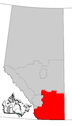
Geography
The region has a total area of approximately 75,500 km2 (29,151 sq mi).
Southern Alberta is in the northern Great Plains region, lined to the east from the Canadian Rocky Mountains and their foothills. The rest of the region is dominated by the semi-arid prairies of the Palliser's Triangle, where farms and ranches have been built, often with the help of irrigation. Rivers generally flow from west to east and include the Oldman River, Bow River, Red Deer River, South Saskatchewan River, and Milk River. Milk River is the only river in Canada that eventually flows into the Gulf of Mexico. [2]
The environment is protected in such areas as Waterton Lakes National Park and Cypress Hills Interprovincial Park, while sites such as Head-Smashed-In Buffalo Jump, Dinosaur Provincial Park and Writing-on-Stone Provincial Park were declared UNESCO World Heritage Sites. The Alberta Badlands are developed in the northeast of the region, prominently along the Red Deer River. Cypress Hills, located in the east, at the border with Saskatchewan, are the highest point between the Rocky Mountains and Labrador.

Alberta is one of the thirteen provinces and territories of Canada. It is a part of Western Canada and is one of the three prairie provinces. Alberta borders British Columbia to the west, Saskatchewan to the east, the Northwest Territories to the north, and the U.S. state of Montana to the south. It is one of the only two landlocked provinces in Canada, with Saskatchewan being the other. The eastern part of the province is occupied by the Great Plains, while the western part borders the Rocky Mountains. The province has a predominantly continental climate but experiences quick temperature changes due to air aridity. Seasonal temperature swings are less pronounced in western Alberta due to occasional Chinook winds.

Medicine Hat is a city in southeast Alberta, Canada. It is located along the South Saskatchewan River. It is approximately 169 km (105 mi) east of Lethbridge and 295 km (183 mi) southeast of Calgary. This city and the adjacent Town of Redcliff to the northwest are within Cypress County. Medicine Hat was the eighth-largest city in Alberta in 2021 with a population of 63,271. It is also the sunniest place in Canada according to Environment and Climate Change Canada, averaging 2,544 hours of sunshine a year.

Alberta is one of the thirteen provinces and territories of Canada. Located in Western Canada, the province has an area of 661,190 km2 (255,290 sq mi) and is bounded to the south by the United States state of Montana along 49° north for 298 km (185 mi); to the east at 110° west by the province of Saskatchewan for 1,223 km (760 mi); and at 60° north the Northwest Territories for 644 km (400 mi). The southern half of the province borders British Columbia along the Continental Divide of the Americas on the peaks of the Rocky Mountains, while the northern half borders British Columbia along the 120th meridian west. Along with Saskatchewan it is one of only two landlocked provinces or territories.

The Cypress Hills are a geographical region of hills in southwestern Saskatchewan and southeastern Alberta, Canada. The hills are part of the Missouri Coteau upland.

Battle Creek is a river that begins in the south-eastern region of the Canadian province of Alberta, near the border with Saskatchewan, in the Cypress Hills Interprovincial Park. From Alberta, Battle Creek flows east and across the border into Saskatchewan. It flows south out of Saskatchewan across the Canada–United States border into Montana, where it joins the Milk River in Blaine County, Montana.

The Oldman River is a river in southern Alberta, Canada. It flows roughly west to east from the Rocky Mountains, through the communities of Fort Macleod, Lethbridge, and on to Grassy Lake, where it joins the Bow River to form the South Saskatchewan River, which eventually drains into the Hudson Bay.
Alberta Provincial Highway No. 2, commonly referred to as Highway 2 or the Queen Elizabeth II Highway, is a major highway in Alberta that stretches from the Canada–United States border through Calgary and Edmonton to Grande Prairie. Running primarily north to south for approximately 1,273 kilometres (791 mi), it is the longest and busiest highway in the province carrying more than 170,000 vehicles per day near Downtown Calgary. The Fort Macleod—Edmonton section forms a portion of the CANAMEX Corridor that links Alaska to Mexico. More than half of Alberta's 4 million residents live in the Calgary–Edmonton Corridor created by Highway 2.

The Red Deer River is a river in Alberta and a small portion of Saskatchewan, Canada. It is a major tributary of the South Saskatchewan River and is part of the larger Saskatchewan / Nelson system that empties into Hudson Bay.

Alberta Provincial Highway No. 3, commonly referred to as Highway 3 and officially named the Crowsnest Highway, is a 324-kilometre (201 mi) highway that traverses southern Alberta, Canada, running from the Crowsnest Pass through Lethbridge to the Trans-Canada Highway in Medicine Hat. Together with British Columbia Highway 3 which begins in Hope, it forms an interprovincial route that serves as an alternate to the Trans-Canada from the Lower Mainland to the Canadian Prairies.
Cypress Hills Interprovincial Park is a natural park in Canada straddling the Alberta / Saskatchewan boundary and jointly administered by the two provinces. Located south-east of Medicine Hat in the Cypress Hills, it became Canada's first interprovincial park in 1989.
Alberta Provincial Highway No. 1, commonly referred to as Highway 1, is a major east–west highway in southern Alberta that forms the southern mainline of the Trans-Canada Highway. It runs from the British Columbia border near Lake Louise through Calgary to the Saskatchewan border east of Medicine Hat. It continues as Highway 1 into both provinces. It spans approximately 534 km (332 mi) from Alberta's border with British Columbia in the west to its border with Saskatchewan in the east. Highway 1 is designated as a core route in Canada's National Highway System and is a core part of the developing Alberta Freeway Network.

Empress is a village in southern Alberta, Canada that is adjacent to the provincial boundary between Alberta and Saskatchewan. It is 121 km (75 mi) north of Medicine Hat. The village was named, in 1913, for Queen Victoria, who was also Empress of India. In the past it was known as the "Hub of the West", connecting major cities together by the Canadian Pacific Railway.
The Alberta Elite Hockey League or AEHL is the provincial U18 "AAA" ice hockey league for Alberta, Canada. The league consists of 17 teams split into the North and South Divisions. League champions go on to compete with the BC Elite Hockey League champions to represent the Pacific at the annual Telus Cup, Canada's national U18 championship. The Calgary Buffaloes are the current league champions. Red Deer is the last AEHL team to win a national title, having won in 2012 & 2013.

Scouting and Guiding in Alberta has a long history, from the 1900s to the present day, serving thousands of youth in programs that suit the environment in which they live.

Leonard Wendelin Mitzel was a Canadian politician and former Member of the Legislative Assembly of Alberta representing the constituency of Cypress-Medicine Hat as a Progressive Conservative.
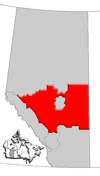
Central Alberta is a region located in the Canadian province of Alberta.
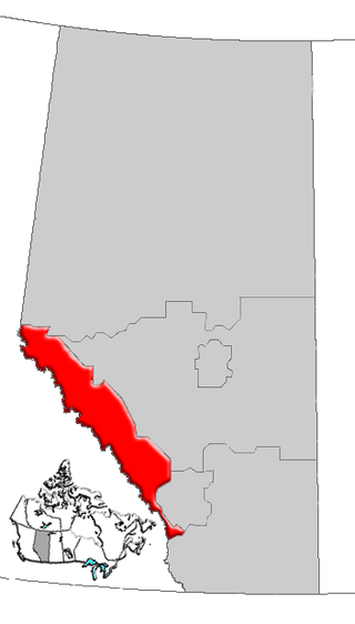
Alberta's Rockies comprise the Canadian Rocky Mountains in Alberta, Canada. On the southwestern part of the province along the British Columbia border, the region covers all but the south of Census Division 15.
The Palliser Region is an area in the southeast corner of the province of Alberta, Canada that has been delineated and is serviced by the Palliser Economic Partnership. It borders the Canadian province of Saskatchewan to the east, and the US state of Montana to the south. It covers an area of 43,504 km2 (16,797 sq mi) The total population of the area stood at 112,314 in 2009. The city of Medicine Hat, with a population of 61,097, is the area's largest urban centre.
The following outline is provided as an overview of and topical guide to Alberta:

Castle Provincial Park is a provincial park in southern Alberta, Canada. It is located within the Municipal District of Pincher Creek No. 9 south of the Municipality of Crowsnest Pass, northwest of Waterton Lakes National Park and west of the Town of Pincher Creek. It shares a boundary with Castle Wildland Provincial Park to the west and south.