The Athabasca River is a river in Alberta, Canada, which originates at the Columbia Icefield in Jasper National Park and flows more than 1,231 km (765 mi) before emptying into Lake Athabasca. Much of the land along its banks is protected in national and provincial parks, and the river is designated a Canadian Heritage River for its historical and cultural importance. The scenic Athabasca Falls is located about 30 km (19 mi) upstream from Jasper.

The Mackenzie River is a river in the Canadian boreal forest. It forms, along with the Slave, Peace, and Finlay, the longest river system in Canada, and includes the second largest drainage basin of any North American river after the Mississippi.

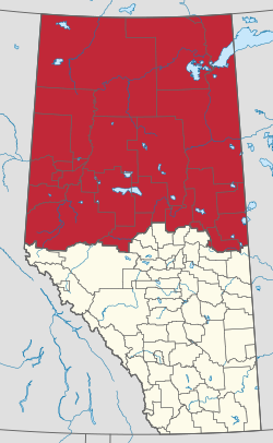
Alberta is one of the thirteen provinces and territories of Canada. Located in Western Canada, the province has an area of 661,190 km2 (255,290 sq mi) and is bounded to the south by the United States state of Montana along 49° north for 298 km (185 mi); to the east at 110° west by the province of Saskatchewan for 1,223 km (760 mi); and at 60° north the Northwest Territories for 644 km (400 mi). The southern half of the province borders British Columbia along the Continental Divide of the Americas on the peaks of the Rocky Mountains, while the northern half borders British Columbia along the 120th meridian west. Along with Saskatchewan it is one of only two landlocked provinces or territories.

Lake Athabasca is in the north-west corner of Saskatchewan and the north-east corner of Alberta between 58° and 60° N in Canada. The lake is 26% in Alberta and 74% in Saskatchewan.

Wood Buffalo National Park is the largest national park of Canada at 44,741 km2 (17,275 sq mi). It is in northeastern Alberta and the southern Northwest Territories. Larger in area than Switzerland, it is the second-largest national park in the world. The park was established in 1922 to protect the world's largest herd of free-roaming wood bison. They became hybridized after the introduction of plains bison. The population is currently estimated at 3,000. It is one of two known nesting sites of whooping cranes.

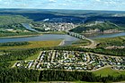
Fort McMurray—Athabasca was a federal electoral district in Alberta, Canada, that was represented in the House of Commons of Canada from 1968 to 2015. It was a predominantly rural riding in northeastern Alberta, representing the Regional Municipality of Wood Buffalo, the Municipal District of Opportunity No. 17, the Municipal District of Lesser Slave River No. 124, Big Lakes County, Lac La Biche County, Athabasca County and the southeastern part of Northern Sunrise County.

The Peace River is a 1,923-kilometre-long (1,195 mi) river in Canada that originates in the Rocky Mountains of northern British Columbia and flows to the northeast through northern Alberta. The Peace River joins the Athabasca River in the Peace-Athabasca Delta to form the Slave River, a tributary of the Mackenzie River. The Finlay River, the main headwater of the Peace River, is regarded as the ultimate source of the Mackenzie River. The combined Finlay–Peace–Slave–Mackenzie river system is the 13th longest river system in the world.

The Peace–Athabasca Delta, located in northeast Alberta, is the largest freshwater inland river delta in North America. It is located partially within the southeast corner of Wood Buffalo National Park, Canada's largest national park, and also spreads into the Regional Municipality of Wood Buffalo, west and south of the historical community of Fort Chipewyan. The delta encompasses approximately 321,200 ha, formed where the Peace and Athabasca rivers converge on the Slave River and Lake Athabasca. The delta region is designated a wetland of international importance and a UNESCO World Heritage Site. The region is large enough that it is considered one of twenty distinct natural subregions of Alberta by the provincial government's Natural Regions Committee.

Northern Alberta Railways was a Canadian railway which served northern Alberta and northeastern British Columbia. Jointly owned by both Canadian National Railway and Canadian Pacific Railway, NAR existed as a separate company from 1929 until 1981.
Highway 2 is a major highway in Alberta that stretches from the Canada–United States border through Calgary and Edmonton to Grande Prairie. Running primarily north to south for approximately 1,273 kilometres (791 mi), it is the longest and busiest highway in the province carrying more than 180,000 vehicles per day near Downtown Calgary. The Fort Macleod—Edmonton section forms a portion of the CANAMEX Corridor that links Alaska to Mexico. More than half of Alberta's 4 million residents live in the Calgary–Edmonton Corridor created by Highway 2.

Dunvegan Provincial Park and Historic Dunvegan are a provincial park and a provincial historic site of Alberta located together on one site. They are located in Dunvegan, at the crossing of Peace River and Highway 2, between Rycroft and Fairview.

The Peace River Country is an aspen parkland region centring on the Peace River in Canada. It extends from northwestern Alberta to the Rocky Mountains in northeastern British Columbia, where a certain portion of the region is also referred to as the Peace River Block.
Wabasca, also known as Wabasca-Desmarais, is a hamlet in northern Alberta, Canada within the Municipal District (MD) of Opportunity No. 17. It is located between and along the South and North Wabasca Lakes, at the intersection of Highway 813 and Highway 754. It is approximately 123 km (76 mi) northeast of Slave Lake.

Wabasca is an oil field in a remote area of northern Alberta, Canada. It is the fourth largest deposit of oil sands located in Alberta, located southwest of the larger Athabasca oil sands deposit. It is also known as the Pelican Lake Oilfield.
Chinchaga Wildland Provincial Park is a wildland provincial park in northwestern Alberta, Canada. The park is a 802.7 square kilometres (310 sq mi) environmentally protected tract of land within the 5,000 km2 (1,900 sq mi) of the greater Chinchaga wilderness area. It is a disjunct outlier of the Foothills Natural Region of Alberta. It was established on 15 December 1999. The greater Chinchaga area was identified in 1995 as an Environmentally Significant Area. It was designated by the Alberta Government as a protected area under the "Special Places" program. The park is administered by the Upper Peace Land Use Framework.

The Fort McKay First Nation (FMFN) is a First Nations government in northeast Alberta comprising five Indian reserves – Fort McKay 174, Fort McKay 174C, Fort McKay 174D, Namur Lake 174B and Namur River 174A. The FMFN, signed to Treaty 8, is affiliated with the Athabasca Tribal Council and its members are of Cree, Metis and Dene heritage. The FMFN's traditional lands include portions of the Athabasca oil sands.
The Clearwater Formation is a stratigraphic unit of Early Cretaceous (Albian) age in the Western Canada Sedimentary Basin in northeastern Alberta, Canada. It was first defined by R.G. McConnell in 1893 and takes its name from the Clearwater River near Fort McMurray.

The Muskwa-Slave Lake Taiga ecoregion covers Canadian taiga in northwestern Alberta, northeastern British Columbia and a large portion of the southwestern Northwest Territories around the Mackenzie River valley and the Great Slave Lake.
Hubert Lake Wildland Provincial Park is a wildland provincial park in central Alberta, Canada. The park was established on 4 October 2000 and has an area of 9,665.46 hectares. The park is included in the Upper Athabasca Region Land Use Framework.
Birch River Wildland Provincial Park is a wildland provincial park in northern Alberta, Canada. It was established on 14 May 2018 and covers 331,832 hectares (1,281.2 sq mi).The park is contained in the Lower Athabasca Region Land Use Framework finalized in 2012. The park is named for the Birch River that flows through it.