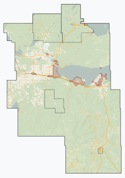
Big Lakes County | |
---|---|
Country | Canada |
Province | Alberta |
Region | Northern Alberta |
Census division | 17 |
Incorporated | 1995 |
Government | |
• Reeve | Robert Nygaard |
• Governing body | Big Lakes County Council |
• Administrative office | High Prairie |
Area (2021) [2] | |
• Land | 13,827.58 km2 (5,338.86 sq mi) |
Population (2021) [2] | |
• Total | 4,986 |
• Density | 0.4/km2 (1/sq mi) |
Time zone | UTC−7 (MST) |
• Summer (DST) | UTC−6 (MDT) |
Website | biglakescounty.ca |
Big Lakes County, formerly the Municipal District of Big Lakes, is a municipal district in north-central Alberta, Canada.
It is located in Census Division 17, around the Lesser Slave Lake. Utikuma Lake and Winagami Lake are also located in the municipality.
Big Lakes County was previously known as the Municipal District of Big Lakes prior to March 6, 2015. [3]
The following urban municipalities are surrounded by Big Lakes County. [4]
| The following hamlets are located within Big Lakes County. [4] |
The following Métis settlements and Indian reserves are located within Big Lakes County.
|
|
The following localities are located within Big Lakes County. [5]
|
|
As a census subdivision in the 2021 Census of Population conducted by Statistics Canada, Big Lakes County had a population of 4,986 living in 2,007 of its 2,632 total private dwellings, a change of -11.4% from its 2016 population of 5,625. With a land area of 13,827.58 km2 (5,338.86 sq mi), it had a population density of 0.4/km2 (0.9/sq mi) in 2021. [2]
As a census subdivision in the 2016 Census of Population conducted by Statistics Canada, Big Lakes County had a population of 5,672 living in 2,099 of its 2,728 total private dwellings, a -4.1% change from its 2011 population of 5,912. [7] This includes the populations of three Métis settlements, East Prairie (304), Gift Lake (658) and Peavine (607), [8] located within the census subdivision that are municipalities independent of Big Lakes County. [4] With a land area of 13,942.43 km2 (5,383.20 sq mi), the census subdivision had a population density of 0.4/km2 (1.1/sq mi) in 2016. [7] Excluding the three Metis settlements, Big Lakes County had a population of 4,103 in 2016, [7] a change of -16.5% from its 2011 population of 4,914. [9]
Big Lakes County's 2013 municipal census counted a population of 3,861, [10] a -7.7% change from its 2002 municipal census population of 4,181. [11]
Big Lakes had the most Métis people per capita of any Canadian census subdivision in 2006 with a population of 5,000 or more due to the census' inclusion of the population of the three Métis settlement municipalities within Big Lakes' totals.
Visible minority and Aboriginal population (Canada 2006 Census) | |||
---|---|---|---|
Population group | Population | % of total population | |
White | 2,815 | 48.5% | |
Visible minority group Source: [12] | South Asian | 20 | 0.3% |
Chinese | 10 | 0.2% | |
Black | 0 | 0% | |
Filipino | 0 | 0% | |
Latin American | 0 | 0% | |
Arab | 0 | 0% | |
Southeast Asian | 0 | 0% | |
West Asian | 0 | 0% | |
Korean | 10 | 0.2% | |
Japanese | 0 | 0% | |
Visible minority, n.i.e. | 0 | 0% | |
Multiple visible minority | 10 | 0.2% | |
Total visible minority population | 60 | 1% | |
Aboriginal group Source: [13] | First Nations | 845 | 14.6% |
Métis | 2,030 | 35% | |
Inuit | 0 | 0% | |
Aboriginal, n.i.e. | 25 | 0.4% | |
Multiple Aboriginal identity | 30 | 0.5% | |
Total Aboriginal population | 2,930 | 50.5% | |
Total population | 5,805 | 100% |
Southeastern parts of the district are within Pembina Hills Public Schools, which formed in 1995 as a merger of three school districts. [14]
Parkland County is a municipal district in central Alberta, Canada. Located west of Edmonton in Census Division No. 11, its municipal office, Parkland County Centre, is located 0.25 km (0.16 mi) north of the Town of Stony Plain on Highway 779.
Foothills County is a municipal district in southern Alberta, Canada adjacent to the south side of Calgary in Census Division No. 6. Despite sharing a common border with the City of Calgary, it does not form part of the Calgary census metropolitan area (CMA) as defined by Statistics Canada. It is however a member municipality of the Calgary Metropolitan Region Board.
The County of Grande Prairie No. 1 is a municipal district in northwestern Alberta, Canada in Census Division No. 19.
The Municipal District of Bonnyville No. 87 is a municipal district (MD) in northeastern Alberta, Canada in Division No. 12. On the east, it is adjacent to the province of Saskatchewan.
Westlock County is a municipal district in central Alberta, Canada that is north of Edmonton. The county was formerly known as the Municipal District of Westlock No. 92, and was created in 1943 from the merger of five smaller municipal districts.
The County of Barrhead No. 11 is a municipal district in north central Alberta, Canada. It is located northwest of Edmonton and is in Census Division No. 13.
Lac La Biche County is a specialized municipality within Division No. 12 in northern Alberta, Canada. It was established through the amalgamation of the Town of Lac La Biche and Lakeland County in 2007.
Beaver County is a municipal district in central-east Alberta, Canada. It is centred on Holden in the western part of Census Division No. 10. Its municipal office is located in Ryley.
Cardston County is a municipal district in southern Alberta, Canada. It is located in Census Division 3 around the Town of Cardston.
Lac Ste. Anne County is a municipal district in central Alberta, Canada.
Woodlands County is a municipal district in north-central Alberta, Canada. Located in Census Division No. 13, its municipal office is located outside but adjacent to the Town of Whitecourt. A second municipal office is located in the Hamlet of Fort Assiniboine.
The Municipal District of Lesser Slave River No. 124 is a municipal district (MD) in north-central Alberta, Canada. Its municipal office is located in the Town of Slave Lake. Located in Census Division 17, the MD takes its name from Lesser Slave River, which drains Lesser Slave Lake into the Athabasca River.
Mackenzie County is a specialized municipality in northern Alberta, Canada. It is located in Census Division 17, along the Mackenzie Highway. The municipal office is located in the hamlet of Fort Vermilion.
The Municipal District of Opportunity No. 17 is a municipal district (MD) occupying a remote area in central northern Alberta, Canada. Located in Census Division 17 north of the Town of Athabasca, its municipal office is located in the Hamlet of Wabasca.
The County of Northern Lights is a municipal district in northwest Alberta, Canada. Located in Census Division 17, its municipal office is located in the Town of Manning.
Smoky Lake County is a municipal district in north-eastern Alberta, Canada. Located in Census Division No. 12, its municipal office is located in the Town of Smoky Lake.
Peavine Metis Settlement is a Metis settlement in northern Alberta, Canada within Big Lakes County. It is located on Highway 750 to the northeast of High Prairie.
Gift Lake Metis Settlement is a Metis settlement in northern Alberta, Canada within Big Lakes County. It is located along Highway 750, approximately 203 km (126 mi) northeast of Grande Prairie.
{{cite map}}
: CS1 maint: date and year (link)5310 - 49th Street Barrhead, Alberta T7N 1P3