Peavine Metis Settlement

Last updated

Peavine Metis Settlement
Metis Settlement
AB locator Peavine Metis Settlement.svg
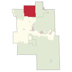
Location within Big Lakes County
Alberta County Point Locator.svg
Red pog.svg
Peavine Metis Settlement
Location within Alberta
Coordinates: 55°51′N116°16′W / 55.850°N 116.267°W / 55.850; -116.267
CountryCanada
Province Alberta
Region Northern Alberta
Census division 17
Government
[1]
  ChairKenneth Noskey
  Governing bodyPeavine Metis Council
Area
 (2021) [2]
  Land328.42 km2 (126.80 sq mi)
Population
 (2021) [2]
  Total310
  Density0.9/km2 (2/sq mi)
Time zone UTC−7 (MST)
  Summer (DST) UTC−6 (MDT)
Peavine Metis Settlement

Peavine Metis Settlement is a Metis settlement in northern Alberta, Canada within Big Lakes County. [3] It is located on Highway 750 to the northeast of High Prairie.

Contents

Demographics

In the 2021 Census of Population conducted by Statistics Canada, Peavine had a population of 387 living in 150 of its 201 total private dwellings, a change of

The population of the Peavine Metis Settlement according to its 2018 municipal census is 566, [4] a decrease from its 2015 municipal census population count of 639. [5]

As a designated place in the 2016 Census of Population conducted by Statistics Canada, the Peavine Metis Settlement had a population of 607 living in 192 of its 284 total private dwellings, a change of

See also

Related Research Articles

<span class="mw-page-title-main">St. Paul, Alberta</span> Town in Alberta, Canada

St. Paul, originally known as St-Paul-de-Métis or St-Paul-des-Métis, is a town in East-Northern Alberta, Canada that is surrounded by the County of St. Paul No. 19. It was known as St. Paul de(s) Métis between 1912 and 1936.

<span class="mw-page-title-main">Municipal District of Bonnyville No. 87</span> Municipal district in Alberta, Canada

The Municipal District of Bonnyville No. 87 is a municipal district (MD) in northeastern Alberta, Canada in Division No. 12. On the east, it is adjacent to the province of Saskatchewan.

<span class="mw-page-title-main">Two Hills, Alberta</span> Town in Alberta, Canada

Two Hills is a town in central Alberta, Canada. It is approximately 137 km (85 mi) east of Edmonton at the junction of Highway 45 and Highway 36. Two Hills is primarily an agriculture-based community. It was named from the presence of two hills located near the town. Post office established in 1914.

<span class="mw-page-title-main">Chauvin, Alberta</span> Village in Alberta, Canada

Chauvin is a village in east central Alberta, Canada. It is located 60 kilometres (37 mi) east of Wainwright, and 10 kilometres (6.2 mi) west of the Saskatchewan border. It is also the home of Susie the Softball, the world's largest softball.

Edgerton is a village in central Alberta, Canada. it is located 35 kilometres (22 mi) east of Wainwright.

<span class="mw-page-title-main">Lac La Biche County</span> Specialized municipality in Alberta, Canada

Lac La Biche County is a specialized municipality within Division No. 12 in northern Alberta, Canada. It was established through the amalgamation of the Town of Lac La Biche and Lakeland County in 2007.

<span class="mw-page-title-main">Big Lakes County</span> Municipal district in Alberta, Canada

Big Lakes County, formerly the Municipal District of Big Lakes, is a municipal district in north-central Alberta, Canada.

<span class="mw-page-title-main">Municipal District of Lesser Slave River No. 124</span> Municipal district in Alberta, Canada

The Municipal District of Lesser Slave River No. 124 is a municipal district (MD) in north-central Alberta, Canada. Its municipal office is located in the Town of Slave Lake. Located in Census Division 17, the MD takes its name from Lesser Slave River, which drains Lesser Slave Lake into the Athabasca River.

<span class="mw-page-title-main">Mackenzie County</span> Specialized municipality in Alberta, Canada

Mackenzie County is a specialized municipality in northern Alberta, Canada. It is located in Census Division 17, along the Mackenzie Highway. The municipal office is located in the hamlet of Fort Vermilion.

<span class="mw-page-title-main">Municipal District of Opportunity No. 17</span> Municipal district in Alberta, Canada

The Municipal District of Opportunity No. 17 is a municipal district (MD) occupying a remote area in central northern Alberta, Canada. Located in Census Division 17 north of the Town of Athabasca, its municipal office is located in the Hamlet of Wabasca.

<span class="mw-page-title-main">County of Northern Lights</span> Municipal district in Alberta, Canada

The County of Northern Lights is a municipal district in northwest Alberta, Canada. Located in Census Division 17, its municipal office is located in the Town of Manning.

<span class="mw-page-title-main">Smoky Lake County</span> Municipal district in Alberta, Canada

Smoky Lake County is a municipal district in north-eastern Alberta, Canada. Located in Census Division No. 12, its municipal office is located in the Town of Smoky Lake.

<span class="mw-page-title-main">Paddle Prairie Metis Settlement</span> Metis settlement in Alberta, Canada

Paddle Prairie Metis Settlement is a Metis settlement in northern Alberta, Canada along the northern boundary of the County of Northern Lights. It is located along the Mackenzie Highway (Highway 35), approximately 72 km (45 mi) south of the Town of High Level. Paddle Prairie Metis Settlement is the largest of eight Metis Settlements in the Province of Alberta. The community is rich in timber, natural resources and agricultural land. The community is also known for constructing solar power generating units for several of its community buildings.

<span class="mw-page-title-main">Gift Lake Metis Settlement</span> Metis Settlement in Alberta, Canada

Gift Lake Metis Settlement is a Metis settlement in northern Alberta, Canada within Big Lakes County. It is located along Highway 750, approximately 203 km (126 mi) northeast of Grande Prairie.

<span class="mw-page-title-main">Fishing Lake Metis Settlement</span> Métis settlement in Alberta, Canada

Fishing Lake Métis Settlement is a Métis settlement in northern Alberta, Canada within the Municipal District of Bonnyville No. 87 and Treaty Six lands. Fishing Lake Métis Settlement was settled by inhabitants of the dissolved St. Paul des Métis settlement and served as a historic Fishing camp to Métis in the region for centuries. It is home to many historical events such as the Frog Lake Resistance and is home to the beginning of the 20th century Métis movement as led by Charles Delorme, Jack Desjarlais and J.F Dion. It is located approximately 15 km (9.3 mi) east of Highway 897 and 52 km (32 mi) south of Cold Lake.

<span class="mw-page-title-main">Elizabeth Metis Settlement</span> Métis settlement in Alberta, Canada

Elizabeth Métis Settlement is a Métis settlement in central Alberta, Canada within the Municipal District of Bonnyville No. 87. It was founded in 1939 after the introduction of the Metis Betterment Act. It is located approximately 20 km (12 mi) east of Highway 897 and 39 km (24 mi) south of Cold Lake and comprises 25,641 hectares of land. Industries such as oil, gas, forestry, and construction are commonly practiced by members of the settlement.

<span class="mw-page-title-main">East Prairie Metis Settlement</span> Metis Settlement in Alberta, Canada

East Prairie Metis Settlement is a Metis settlement in northern Alberta, Canada within Big Lakes County. It is located approximately 20 km (12 mi) south of Highway 2 and 168 km (104 mi) east of Grande Prairie. It was founded in 1939.

<span class="mw-page-title-main">Buffalo Lake Metis Settlement</span> Metis Settlement in Alberta, Canada

Buffalo Lake Metis Settlement is a Metis settlement in northern Alberta, Canada within Smoky Lake County. It is located along Highway 855, approximately 125 km (78 mi) northeast of Edmonton.

References

  1. "Municipal Officials Search". Alberta Municipal Affairs. May 9, 2019. Retrieved October 1, 2021.
  2. 1 2 3 "Population and dwelling counts: Canada and designated places". Statistics Canada. February 9, 2022. Retrieved February 10, 2022.
  3. "Specialized and Rural Municipalities and Their Communities" (PDF). Alberta Municipal Affairs. 2012-11-05. Retrieved 2012-11-20.
  4. 2019 Municipal Affairs Population List (PDF). Alberta Municipal Affairs. December 2019. ISBN   978-1-4601-4623-1 . Retrieved September 28, 2021.
  5. 2016 Municipal Affairs Population List (PDF). Alberta Municipal Affairs. ISBN   978-1-4601-3127-5 . Retrieved September 28, 2021.
  6. "Population and dwelling counts, for Canada, provinces and territories, and designated places, 2016 and 2011 censuses – 100% data (Alberta)". Statistics Canada. February 8, 2017. Retrieved February 9, 2017.