Chipewyan 201E | |
---|---|
Chipewyan Indian Reserve No. 201E | |
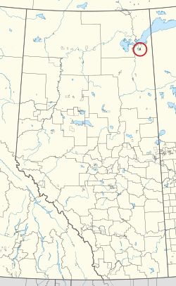
First Nation | Athabasca Chipewyan |
Treaty | 8 |
Country | Canada |
Province | Alberta |
Specialized municipality | Wood Buffalo |
Area | |
• Total | 4,165.5 ha (10,293.2 acres) |
Chipewyan 201E is an Indian reserve of the Athabasca Chipewyan First Nation in Alberta, located within the Regional Municipality of Wood Buffalo. [2] It is on the east side of Richardson Lake, about 7 miles south of Lake Athabasca. [1]
Fort Chipewyan, commonly referred to as Fort Chip, is a hamlet in northern Alberta, Canada, within the Regional Municipality (RM) of Wood Buffalo. It is located on the western tip of Lake Athabasca, adjacent to Wood Buffalo National Park, approximately 223 kilometres (139 mi) north of Fort McMurray.
Wood Buffalo National Park is the largest national park of Canada at 44,741 km2 (17,275 sq mi). It is located in northeastern Alberta and the southern Northwest Territories. Larger in area than Switzerland, it is the second-largest national park in the world. The park was established in 1922 to protect the world's largest herd of free-roaming wood bison. They became hybridized after the introduction of plains bison. The population is currently estimated at about 3,000. It is one of two known nesting sites of whooping cranes.
The Chipewyan are a Dene Indigenous Canadian people of the Athabaskan language family, whose ancestors are identified with the Taltheilei Shale archaeological tradition. They are part of the Northern Athabascan group of peoples, and come from what is now Western Canada.
The Regional Municipality of Wood Buffalo is a specialized municipality in northeast Alberta, Canada. It is the second largest municipality in Alberta by area and is home to oil sand deposits known as the Athabasca oil sands.
The Athabasca Basin is a region in the Canadian Shield of northern Saskatchewan and Alberta, Canada. It is best known as the world's leading source of high-grade uranium and currently supplies about 20% of the world's uranium.
Division No. 16 is a census division in Alberta, Canada. It is located in the northeast portion of northern Alberta and surrounds the Urban Service Area of Fort McMurray.
The Chipewyan Prairie First Nation is a First Nations band government located in northeast Alberta south of Fort McMurray.
The Athabasca Chipewyan First Nation is a band government. It represents local people of the Denesuline (Chipewyan) ethnic group. It controls eight Indian reserves: Chipewyan 201 and Chipewyan 201A through Chipewyan 201G, near Fort Chipewyan, Alberta. The band is party to Treaty 8, and is a member of the Athabasca Tribal Council.
Fort McMurray First Nation is a Cree and Chipewyan band government located near Fort McMurray, Alberta. It is a member of the Athabasca Tribal Council and a Treaty 8 nation. The Athabasca Tribal Council represents 5 First Nation bands in northeast Alberta. Fort McMurray First Nation is governed by a Chief and two councillors.
Black Lake is a Denesuline First Nations band government in the boreal forest of northern Saskatchewan, Canada. It is located on the northwest shore of Black Lake where the Fond du Lac River leaves the lake to flow to Lake Athabasca.
Chipewyan 201 is an Indian reserve of the Athabasca Chipewyan First Nation in Alberta, located within the Regional Municipality of Wood Buffalo on the south shore of Lake Athabasca.
Cowper Lake 194A is an Indian reserve of the Chipewyan Prairie First Nation in Alberta, located within the Regional Municipality of Wood Buffalo.
Janvier 194 is an Indian reserve of the Chipewyan Prairie First Nation in Alberta, Canada that is surrounded by the Regional Municipality of Wood Buffalo. It is 97 km (60 mi) southwest of Fort McMurray.
Chipewyan 201A is an Indian reserve of the Athabasca Chipewyan First Nation in Alberta, located within the Regional Municipality of Wood Buffalo. It is at the southeast end of Lake Athabasca.
Chipewyan 201B is an Indian reserve of the Athabasca Chipewyan First Nation in Alberta, located within the Regional Municipality of Wood Buffalo. It is 16 miles (26 km) southeast of Fort Chipewyan.
Chipewyan 201C is an Indian reserve of the Athabasca Chipewyan First Nation in Alberta, located within the Regional Municipality of Wood Buffalo. It is on the east side of Richardson Lake, about 7 miles south of Lake Athabasca.
Chipewyan 201D is an Indian reserve of the Athabasca Chipewyan First Nation in Alberta, located within the Regional Municipality of Wood Buffalo. It is on the east side of Richardson Lake, about 7 miles south of Lake Athabasca.
Chipewyan 201F is an Indian reserve of the Athabasca Chipewyan First Nation in Alberta, located within the Regional Municipality of Wood Buffalo.
Chipewyan 201G is an Indian reserve of the Athabasca Chipewyan First Nation in Alberta, located within the Regional Municipality of Wood Buffalo. It is on the east bank of the Athabasca River, 37 miles south of Embarras Portage.
Winefred Lake 194B is an Indian reserve of the Chipewyan Prairie First Nation in Alberta, located within the Regional Municipality of Wood Buffalo.
58°22′33″N110°56′51″W / 58.375808°N 110.94756°W