Stoney 142, 143, 144

Last updated
Stoney 142, 143, 144
Stoney Indian Reserve Nos. 142, 143, and 144
CAN AB 4893 STONEY INDIAN RESERVES -142, -143, -144 MAP.svg
Boundaries of Stoney 142, 143, 144
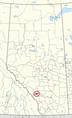
CAN AB 289 STONEY INDIAN RESERVES -142, -143, -144.svg
Location in Alberta
First Nations Stoney Nakoda
Treaty 7
Country Canada
Province Alberta
Municipal districts Bighorn No. 8
Rocky View County
Area
[1]
  Total39,264.5 ha (97,024.7 acres)
Population
 (2016) [2]
  Total3,713
  Density9.5/km2 (24/sq mi)

Stoney 142, 143, 144 is an Indian reserve of the Stoney Nakoda First Nation, comprising Bearspaw, Chiniki, and Wesley First Nations in Alberta, located between the Municipal District of Bighorn No. 8 and Rocky View County. [3] The largest community of the Nakoda people, it is 56 kilometers west of Calgary. [1]

Contents

The community is spread along both sides of the Trans-Canada Highway, east of Banff National Park and north of Kananaskis Improvement District. In addition to Kananaskis, it is also bordered by Bighorn No. 8, Rocky View County, and the town of Cochrane. By land area, it is the third-largest Indian reserve in Canada (after Blood 148 and Siksika 146, both also in Alberta).

According to the Canada 2011 Census:

History

Most of the film Buffalo Bill and the Indians, or Sitting Bull's History Lesson was shot on location on the reserve. [4] Frank "Sitting Wind" Kaquitts, who played Sitting Bull in the film, had been elected the first ever chief of Alberta's Nakoda (Stoney) First Nation, after three bands had amalgamated the year before. [5] [6] Kevin Costner's Open Range was also filmed on the reserve. The film Little Big Man starring Dustin Hoffman and Chief Dan George was shot here also, and the first screening was held in Calgary so the tribe could attend.

The Stoney Reserve was badly damaged by a massive flood in June 2013 and hundreds of residents were evacuated from their homes. [7]

See also

Related Research Articles

<span class="mw-page-title-main">Kananaskis Country</span> Multiple use area west of Calgary, Alberta, Canada

Kananaskis Country is a multi-use area west of Calgary, Alberta, Canada in the foothills and front ranges of the Canadian Rockies. The area is named for the Kananaskis River, which was named by John Palliser in 1858 after a Cree acquaintance. Covering an area of approximately 4,000 km2 (1,500 sq mi), Kananaskis Country was formed by the Alberta Government in 1978 to provide an assortment of land uses and designations. Land uses include resource extraction activities, recreation, power generation, and residential communities. Land designations include public land and protected areas.

<span class="mw-page-title-main">Anûkathâ Îpa</span> Mountain in Alberta, Canada

Anûkathâ Îpa is an outlier of Mount Charles Stewart in the Canadian Rockies of Alberta. It is one of the most prominent landmarks in the vicinity of Canmore, Alberta.

<span class="mw-page-title-main">Mount John Laurie</span> Mountain in Alberta, Canada

Mount John Laurie is a mountain in the Canadian Rockies, in Alberta's Municipal District of Bighorn No. 8.

<span class="mw-page-title-main">Assiniboine</span> First Nations people native to the northern Great Plains of North America

The Assiniboine or Assiniboin people, also known as the Hohe and known by the endonym Nakota, are a First Nations/Native American people originally from the Northern Great Plains of North America.

<span class="mw-page-title-main">The Three Sisters (Alberta)</span> Trio of mountains in Alberta, Canada

The Three Sisters are a trio of peaks near Canmore, Alberta, Canada. They are known individually as Big Sister, Middle Sister and Little Sister.

<span class="mw-page-title-main">Treaty 7</span> Treaty between First Nations and Canadian Crown

Treaty 7 is an agreement between the Crown and several, mainly Blackfoot, First Nation band governments in what is today the southern portion of Alberta. The idea of developing treaties for Blackfoot lands was brought to Blackfoot chief Crowfoot by John McDougall in 1875. It was concluded on September 22nd, 1877 and December 4th, 1877. The agreement was signed at the Blackfoot Crossing of the Bow River, at the present-day Siksika Nation reserve, approximately 75 km (47 mi) east of Calgary, Alberta. Chief Crowfoot was one of the signatories to Treaty 7. Another signing on this treaty occurred on December 4, 1877 to accommodate some Blackfoot leaders who were not present at the primary September 1877 signing.

First Nations in Alberta are a group of people who live in the Canadian province of Alberta. The First Nations are peoples recognized as Indigenous peoples or Plains Indians in Canada excluding the Inuit and the Métis. According to the 2011 Census, a population of 116,670 Albertans self-identified as First Nations. Specifically there were 96,730 First Nations people with registered Indian Status and 19,945 First Nations people without registered Indian Status. Alberta has the third largest First Nations population among the provinces and territories. From this total population, 47.3% of the population lives on an Indian reserve and the other 52.7% live in urban centres. According to the 2011 Census, the First Nations population in Edmonton totalled at 31,780, which is the second highest for any city in Canada. The First Nations population in Calgary, in reference to the 2011 Census, totalled at 17,040. There are 48 First Nations or "bands" in Alberta, belonging to nine different ethnic groups or "tribes" based on their ancestral languages.

<span class="mw-page-title-main">Peter Lougheed Provincial Park</span> Provincial park in Alberta, Canada

Peter Lougheed Provincial Park is in Kananaskis Country about 90 kilometres (56 mi) west of Calgary, along the Kananaskis Trail in Alberta, Canada.

<span class="mw-page-title-main">Division No. 15, Alberta</span> Census division in Alberta, Canada

Division No. 15 is a census division in Alberta, Canada. The majority of the division is located in Alberta's Rockies, while the southernmost portion of the division is located within southern Alberta. The division's largest urban community is the Town of Canmore.

<span class="mw-page-title-main">Nakoda people</span> First Nations people in Western Canada

The Nakoda (also known as Stoney, Îyârhe Nakoda, or Stoney Nakoda are an Indigenous people in Western Canada and, originally, the United States.

Seebe is a former hamlet and ghost town in Alberta, Canada, within the Municipal District of Bighorn No. 8. It is a former Calgary Power Company Ltd. employee townsite that was closed on August 31, 2004.

<span class="mw-page-title-main">Abraham Lake</span> A lake in Alberta, Canada

Abraham Lake, also known as Lake Abraham, is an artificial lake and Alberta's largest reservoir. It is located in the "Kootenay Plains area of the Canadian Rockies' front range", on the North Saskatchewan River in western Alberta, Canada.

The Alexis Nakota Sioux Nation no. 437 is a Nakoda First Nation which reserves near Edmonton, Hinton, and Whitecourt, in the Canadian province of Alberta, and headquartered at 54° N and 114°, about 85 kilometres (53 mi) west of Edmonton. The Alexis Nakota Sioux Nation is a member of Treaty 6.

Mini Thni is a First Nations settlement within the Stoney 142/143/144 Indian reserve in southern Alberta, Canada. It is located along the Canadian Pacific Railway between the Trans-Canada Highway and the Bow River, upstream from Ghost Lake. It has an elevation of 1,240 metres (4,070 ft). The settlement is located in census division No. 15 and in the federal riding of Wild Rose. The settlement and the Indian reserve are part of the Stoney Nation.

<span class="mw-page-title-main">Big Horn 144A</span> Indian reserve in Stoney Nakoda *Bearspaw *Chiniki *Wesley

Big Horn 144A is an Indian reserve of the Stoney Nakoda First Nation, comprising Bearspaw, Chiniki, and Wesley First Nations in Alberta, located within Clearwater County. In the 2016 Canadian Census, it recorded a population of 237 living in 44 of its 59 total private dwellings.

John Reilly is a former judge and best selling author. He served for 33 years as a judge of the Provincial Court of Alberta, largely in the area around Canmore and Cochrane, Alberta, until retiring in 2008.

<span class="mw-page-title-main">Banff-Kananaskis</span> Provincial electoral district in Alberta, Canada

Banff-Kananaskis is a provincial electoral district in Alberta, Canada. The district is one of 87 districts mandated to return a single member (MLA) to the Legislative Assembly of Alberta using the first past the post method of voting. It was contested for the first time in the 2019 Alberta election.

<span class="mw-page-title-main">Stoney 142B</span> Indian reserve in Stoney Nakoda *Bearspaw *Chiniki *Wesley

Stoney 142B is an Indian reserve of the Stoney Nakoda First Nation, comprising Bearspaw, Chiniki, and Wesley First Nations in Alberta, located within the Municipal District of Bighorn No. 8. It is 48 kilometres northwest of Calgary, Alberta, Canada.

The Rocky Mountain Outlook is a weekly local newspaper based in Canmore, Alberta, Canada. The Rocky Mountain Outlook is delivered across the Bow Valley in Banff, Canmore, Lake Louise, the Municipal District of Bighorn and the Stoney Nakoda First Nation. The paper covers news in and around the Bow Valley region, which spans from Lake Louise in the west to the Stoney Nakoda First Nation and Kananaskis Country in the east. The paper does not charge readers and relies on advertising for income.

Stoney Nakoda First Nation is a Nakoda First Nations band government Alberta, Canada. It is located West of Calgary, in the foot of the Rocky Mountains.

References

  1. 1 2 "Reserve/Settlement/Village Detail". Crown–Indigenous Relations and Northern Affairs Canada . Government of Canada. Retrieved August 12, 2019.
  2. "Census Profile, 2016 Census". Statistics Canada. February 8, 2017. Retrieved 2019-08-10.
  3. Government of Alberta (May 25, 2019). Municipal Boundaries (Map). AltaLIS.
  4. Kainai News, 23 May 1975
  5. Warren Harbeck, One last mountain journey with Sitting Wind, Cochrane Eagle, November 27, 2002
  6. Sitting Wind, Rocky Mountain Nakoda
  7. Siksika and Stoney are the First Nations hit hardest by floods, says chief, Calgary Herald, June 25, 2013

51°09′N114°56′W / 51.150°N 114.933°W / 51.150; -114.933