Namur River 174A

Last updated
Namur River 174A
Namur River Indian Reserve No. 174A
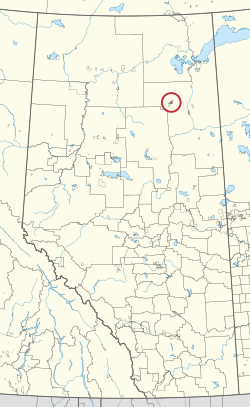
CAN AB 148 NAMUR RIVER INDIAN RESERVE -174A.svg
Location in Alberta
First Nation Fort McKay
Treaty 8
Country Canada
Province Alberta
Specialized municipality Wood Buffalo
Area
[1]
  Total4,614.9 ha (11,403.7 acres)

Namur River 174A is an Indian reserve of the Fort McKay First Nation in Alberta, located within the Regional Municipality of Wood Buffalo. [2] It is 65 kilometres northwest of Fort McMurray. [1]

Related Research Articles

<span class="mw-page-title-main">Chipewyan</span> Indigenous people of northwestern Canada

The Chipewyan are a Dene Indigenous Canadian people of the Athabaskan language family, whose ancestors are identified with the Taltheilei Shale archaeological tradition. They are part of the Northern Athabascan group of peoples, and come from what is now Western Canada.

<span class="mw-page-title-main">Regional Municipality of Wood Buffalo</span> Municipality in Alberta, Canada

The Regional Municipality of Wood Buffalo is a specialized municipality in northeast Alberta, Canada. It is the second largest municipality in Alberta by area and is home to oil sand deposits known as the Athabasca oil sands.

<span class="mw-page-title-main">Division No. 16, Alberta</span> Census division in Alberta, Canada

Division No. 16 is a census division in Alberta, Canada. It is located in the northeast portion of northern Alberta and surrounds the Urban Service Area of Fort McMurray.

<span class="mw-page-title-main">Fort McKay First Nation</span>

The Fort McKay First Nation (FMFN) is a First Nations government in northeast Alberta comprising five Indian reserves – Fort McKay 174, Fort McKay 174C, Fort McKay 174D, Namur Lake 174B and Namur River 174A. The FMFN, signed to Treaty 8, is affiliated with the Athabasca Tribal Council and its members are of Cree, Metis and Dene heritage. The FMFN's traditional lands include portions of the Athabasca oil sands.

<span class="mw-page-title-main">Boyer 164</span> Indian reserve in Beaver

Boyer River 164 is an Indian reserve of the Beaver First Nation in Alberta, located within Mackenzie County. It is 16 kilometers northwest of Fort Vermilion. In the 2016 Canadian Census, it recorded a population of 218 living in 63 of its 67 total private dwellings.

<span class="mw-page-title-main">Clearwater 175</span> Indian reserve in Fort McMurray

Clearwater 175 is an Indian reserve of the Fort McMurray First Nation in Alberta, located within the Regional Municipality of Wood Buffalo. It is 7 kilometers southeast of Fort McMurray.

<span class="mw-page-title-main">Gregoire Lake 176</span> Indian reserve in Fort McMurray

Gregoire Lake 176 is an Indian reserve of the Fort McMurray First Nation in Alberta, located within the Regional Municipality of Wood Buffalo. It is 35 kilometres southeast of Fort McMurray. In the 2016 Canadian Census, it recorded a population of 191 living in 62 of its 74 total private dwellings.

<span class="mw-page-title-main">Janvier 194</span> Indian reserve in Chipewyan Prairie

Janvier 194 is an Indian reserve of the Chipewyan Prairie First Nation in Alberta, Canada that is surrounded by the Regional Municipality of Wood Buffalo. It is 97 km (60 mi) southwest of Fort McMurray.

Namur 174 may refer to one of two adjacent Indian reserves northwest of Fort McMurray in Alberta, Canada, both owned by the Fort McKay First Nation:

<span class="mw-page-title-main">Old Fort 217</span> Indian reserve in Mikisew Cree

Old Fort 217 is an Indian reserve of the Mikisew Cree First Nation in Alberta, located within Regional Municipality of Wood Buffalo. In the 2016 Canadian Census, it recorded a population of 0 living in 0 private dwellings. It is located 188 kilometres (117 mi) north of Fort McMurray, at an elevation of 214 metres (702 ft). In 2001, there were 5 people living on-reserve.

<span class="mw-page-title-main">Peace Point 222</span> Indian reserve in Mikisew Cree

Peace Point 222 is an Indian reserve of the Mikisew Cree First Nation in Alberta, located within Improvement District No. 24.

<span class="mw-page-title-main">Namur Lake 174B</span> Indian reserve in Fort McKay

Namur Lake 174B is an Indian reserve of the Fort McKay First Nation in Alberta, located within the Regional Municipality of Wood Buffalo. It is 105 kilometres northwest of Fort McMurray.

<span class="mw-page-title-main">Fort McKay 174</span> Indian reserve in Fort McKay

Fort McKay 174 is an Indian reserve of the Fort McKay First Nation in Alberta, located within the Regional Municipality of Wood Buffalo.

<span class="mw-page-title-main">Fort McKay 174C</span> Indian reserve in Fort McKay

Fort McKay 174C is an Indian reserve of the Fort McKay First Nation in Alberta, located within the Regional Municipality of Wood Buffalo.

<span class="mw-page-title-main">Fort McKay 174D</span> Indian reserve in Fort McKay

Fort McKay 174D is an Indian reserve of the Fort McKay First Nation in Alberta, located within the Regional Municipality of Wood Buffalo.

<span class="mw-page-title-main">Tallcree 173A</span> Indian reserve in Tallcree

Tallcree 173A, also known as North Tallcree, is an Indian reserve of the Tallcree First Nation in Alberta, located within Mackenzie County. It is 40 kilometres (25 mi) southeast of Fort Vermilion. In the 2021 Canadian Census, Tallcree 173A had a recorded population of 201 living in 50 of its 56 total private dwellings.

<span class="mw-page-title-main">Tsʼu Nedhé 196H</span> Indian reserve in Smiths Landing

Tsʼu Nedhé 196H is an Indian reserve of the Smith's Landing First Nation in Alberta, located within Improvement District No. 24.

<span class="mw-page-title-main">Woodland Cree 226</span> Indian reserve in Woodland Cree

Woodland Cree 226 is an Indian reserve of the Woodland Cree First Nation in Alberta, located within Northern Sunrise County. It is 48 kilometres northeast of Peace River. In the 2016 Canadian Census, it recorded a population of 723 living in 188 of its 211 total private dwellings.

References

  1. 1 2 "Reserve/Settlement/Village Detail". Crown–Indigenous Relations and Northern Affairs Canada . Government of Canada. Retrieved August 12, 2019.
  2. Government of Alberta (May 25, 2019). Municipal Boundaries (Map). AltaLIS.

57°29′25″N112°31′39″W / 57.4903°N 112.5275°W / 57.4903; -112.5275 (Namur River 174A)