William McKenzie 151K

Last updated
William McKenzie 151K
William McKenzie Indian Reserve No. 151K
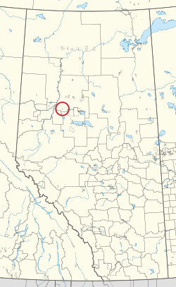
CAN AB 245 WILLIAM MCKENZIE INDIAN RESERVE -151K.svg
Location in Alberta
First Nation Duncan's
Treaty 8
Country Canada
Province Alberta
Municipal district Northern Sunrise
Area
[1]
  Total389.3 ha (962.0 acres)

William McKenzie 151K is an Indian reserve of the Duncan's First Nation in Alberta, located within Northern Sunrise County. [2] It is 33 kilometres north of McLennan. [1]

Related Research Articles

<span class="mw-page-title-main">Alexis Elk River 233</span> Indian reserve in Alexis Nakota Sioux

Alexis Elk River 233 is an Indian reserve of the Alexis Nakota Sioux Nation in Alberta, located within Yellowhead County. It is 87 kilometers southeast of Hinton.

<span class="mw-page-title-main">Big Horn 144A</span> Indian reserve in Stoney Nakoda *Bearspaw *Chiniki *Wesley

Big Horn 144A is an Indian reserve of the Stoney Nakoda First Nation, comprising Bearspaw, Chiniki, and Wesley First Nations in Alberta, located within Clearwater County. In the 2016 Canadian Census, it recorded a population of 237 living in 44 of its 59 total private dwellings.

<span class="mw-page-title-main">Boyer 164</span> Indian reserve in Beaver

Boyer River 164 is an Indian reserve of the Beaver First Nation in Alberta, located within Mackenzie County. It is 16 kilometers northwest of Fort Vermilion. In the 2016 Canadian Census, it recorded a population of 218 living in 63 of its 67 total private dwellings.

<span class="mw-page-title-main">Bushe River 207</span> Indian reserve in Dene Tha

Bushe River 207 is an Indian reserve of the Dene Tha' First Nation in Alberta, located within Mackenzie County. To the west, it is adjacent to the town of High Level. In the 2016 Canadian Census, it recorded a population of 503 living in 134 of its 142 total private dwellings.

<span class="mw-page-title-main">Child Lake 164A</span> Indian reserve in Beaver

Child Lake 164A is an Indian reserve of the Beaver First Nation in Alberta, located within Mackenzie County. It is 32 kilometers northwest of Fort Vermilion. The reserve takes its name from a nearby lake where a child once drowned.

<span class="mw-page-title-main">Clear Hills 152C</span> Indian reserve in Horse Lake

Clear Hills 152C is an Indian reserve of the Horse Lake First Nation in Alberta, located within Clear Hills County. It is 56 kilometers northwest of Fairview. In the 2016 Canadian Census, it recorded a population of 0 living in 1 of its 5 total private dwellings.

<span class="mw-page-title-main">Clearwater 175</span> Indian reserve in Fort McMurray

Clearwater 175 is an Indian reserve of the Fort McMurray First Nation in Alberta, located within the Regional Municipality of Wood Buffalo. It is 7 kilometers southeast of Fort McMurray.

<span class="mw-page-title-main">Duncan's 151A</span> Indian reserve in Duncans

Duncan's 151A is an Indian reserve of the Duncan's First Nation in Alberta, located within the Municipal District of Peace No. 135. It is 39 kilometers southwest of Peace River. In the 2016 Canadian Census, it recorded a population of 150 living in 52 of its 56 total private dwellings.

<span class="mw-page-title-main">Gregoire Lake 176</span> Indian reserve in Fort McMurray

Gregoire Lake 176 is an Indian reserve of the Fort McMurray First Nation in Alberta, located within the Regional Municipality of Wood Buffalo. It is 35 kilometres southeast of Fort McMurray. In the 2016 Canadian Census, it recorded a population of 191 living in 62 of its 74 total private dwellings.

<span class="mw-page-title-main">Janvier 194</span> Indian reserve in Chipewyan Prairie

Janvier 194 is an Indian reserve of the Chipewyan Prairie First Nation in Alberta, Canada that is surrounded by the Regional Municipality of Wood Buffalo. It is 97 km (60 mi) southwest of Fort McMurray.

<span class="mw-page-title-main">Kapawe'no 150B</span> Indian reserve in Kapaweno

Kapawe'no 150B, historically known as Freeman 150B, is an Indian reserve of the Kapawe'no First Nation in Alberta, located within Big Lakes County. It is 8 kilometers northwest of Lesser Slave Lake. In the 2016 Canadian Census, it recorded a population of 154 living in of its 45 total private dwellings.

<span class="mw-page-title-main">Sucker Creek 150A</span> Indian reserve in Sucker Creek

Sucker Creek 150A is an Indian reserve of the Sucker Creek First Nation in Alberta, located within Big Lakes County. It is 22 kilometres south of High Prairie. In the 2016 Canadian Census, it recorded a population of 689 living in 235 of its 274 total private dwellings.

<span class="mw-page-title-main">Kapawe'no 150C</span> Indian reserve in Kapaweno

Kapawe'no 150C, formerly known as Halcro 150C, is an Indian reserve of the Kapawe'no First Nation in Alberta, located within Big Lakes County. It is 17 kilometres northeast of High Prairie.

<span class="mw-page-title-main">Kapawe'no 150D</span> Indian reserve in Kapaweno

Kapawe'no 150D, formerly known as Pakashan 150D, is an Indian reserve of the Kapawe'no First Nation in Alberta, located within Big Lakes County. It is 13 kilometres northwest of Lesser Slave Lake. In the 2016 Canadian Census, it recorded a population of 5 living in 4 of its 7 total private dwellings.

<span class="mw-page-title-main">Kapawe'no 229</span> Indian reserve in Kapaweno

Kapawe'no 229 is an Indian reserve of the Kapawe'no First Nation in Alberta, located within Big Lakes County. It is 27 kilometres northeast of High Prairie.

<span class="mw-page-title-main">Kapawe'no 230</span> Indian reserve in Kapaweno

Kapawe'no 230 is an Indian reserve of the Kapawe'no First Nation in Alberta, located within Big Lakes County. It is 25 kilometres northeast of High Prairie.

<span class="mw-page-title-main">Swampy Lake 236</span> Indian reserve of the Loon River First Nation in Alberta, Canada

Swampy Lake 236 is an Indian reserve of the Loon River First Nation in Alberta, located within Northern Sunrise County. It is 6 kilometres west of Loon Lake.

<span class="mw-page-title-main">Woodland Cree 226</span> Indian reserve in Woodland Cree

Woodland Cree 226 is an Indian reserve of the Woodland Cree First Nation in Alberta, located within Northern Sunrise County. It is 48 kilometres northeast of Peace River. In the 2016 Canadian Census, it recorded a population of 723 living in 188 of its 211 total private dwellings.

<span class="mw-page-title-main">Woodland Cree 227</span> Indian reserve in Woodland Cree

Woodland Cree 227 is an Indian reserve of the Woodland Cree First Nation in Alberta, located within Northern Sunrise County. It is 60 kilometres northeast of Peace River.

<span class="mw-page-title-main">Woodland Cree 228</span> Indian reserve in Woodland Cree

Woodland Cree 228 is an Indian reserve of the Woodland Cree First Nation in Alberta, located within Northern Sunrise County. It is 75 kilometres northeast of Peace River. In the 2016 Canadian Census, it recorded a population of 150 living in 33 of its 36 total private dwellings.

References

  1. 1 2 "Reserve/Settlement/Village Detail". Crown–Indigenous Relations and Northern Affairs Canada . Government of Canada. Retrieved August 12, 2019.
  2. Government of Alberta (May 25, 2019). Municipal Boundaries (Map). AltaLIS.

56°00′21″N116°51′58″W / 56.0059°N 116.8662°W / 56.0059; -116.8662 (William McKenzie 151K)