Little Buffalo, Alberta

Last updated
Little Buffalo
Canada Alberta location map 2.svg
Red pog.svg
Location of Little Buffalo in Alberta
Coordinates: 56°26′15″N116°06′27″W / 56.4375°N 116.1075°W / 56.4375; -116.1075 Coordinates: 56°26′15″N116°06′27″W / 56.4375°N 116.1075°W / 56.4375; -116.1075
CountryFlag of Canada (Pantone).svg  Canada
Province Flag of Alberta.svg  Alberta
Census division No. 19
Municipal district Northern Sunrise County
Founded1953
Government
  Type Unincorporated
  Governing body Northern Sunrise County Council
  Ward 6 CouncillorDarlene Cardinal
Population
(2010) [1]
  Total225
Time zone UTC-7 (MST)

Little Buffalo is a hamlet in northern Alberta, Canada within Northern Sunrise County. [2] It is located on Highway 986, approximately 100 kilometres (62 mi) northeast of the Town of Peace River and 47 kilometres (29 mi) west of Highway 88. Little Buffalo Lake is to the south of the community.

Hamlet (place) small settlement in a rural area

A hamlet is a small human settlement. In different jurisdictions and geographies, hamlets may be the size of a town, village or parish, be considered a smaller settlement or subdivision or satellite entity to a larger settlement. The word and concept of a hamlet have roots in the Anglo-Norman settlement of England, where the old French hamlet came to apply to small human settlements. In British geography, a hamlet is considered smaller than a village and distinctly without a church.

Northern Alberta geographical object

Northern Alberta is a region located in the Canadian province of Alberta.

Canada Country in North America

Canada is a country in the northern part of North America. Its ten provinces and three territories extend from the Atlantic to the Pacific and northward into the Arctic Ocean, covering 9.98 million square kilometres, making it the world's second-largest country by total area. Canada's southern border with the United States is the world's longest bi-national land border. Its capital is Ottawa, and its three largest metropolitan areas are Toronto, Montreal, and Vancouver. As a whole, Canada is sparsely populated, the majority of its land area being dominated by forest and tundra. Consequently, its population is highly urbanized, with over 80 percent of its inhabitants concentrated in large and medium-sized cities, many near the southern border. Canada's climate varies widely across its vast area, ranging from arctic weather in the north, to hot summers in the southern regions, with four distinct seasons.

Contents

Land claims

"The Lubicon Lake Indian Band land claim has a history dating back one hundred years, when the Band was left out of the original Treaty Eight signing by government agents in 1889." [3] On October 22, 1988, Lubicon Chief Bernard Ominayak and Alberta Provincial Premier Don Getty negotiated an agreement, since called the "Grimshaw Accord". [4] through which the Province of Alberta transferred 79 square miles of land (with full surface and sub-surface rights) to the Government of Canada to establish a reserve for the Lubicon First Nation On 10 June 2013, on behalf of the Lubicon Cree, aboriginal rights lawyer, James O'Reilly sent letters to Shell Canada, PineCrest, Atco, Andora Energy Corp., Clean Harbours, Mancal Energy Inc. and Penn West Petroleum which operate in the disputed land claims area, warning that their resource projects will be "vigorously opposed" unless they have the consent of the First Nation. [5]

The Muskotew Sakahikan Enowuk or Lubicon Lake Nation is a Cree First Nation in Northern Alberta, Canada. They are commonly referred to as the Lubicon Lake Nation, Lubicon Cree, or the Lubicon Lake Cree. This should not be confused with the Lubicon Lake Band #453, which is a separate entity created by the Government of Canada by Order in Council in 1973.

2011 Little Buffalo oil spill

The Little Buffalo oil spill on April 29, 2011, resulted in the discharge of 28,000 barrels of oil in an isolated stretch of boreal forest in northern Alberta, approximately 10 kilometres (6.2 mi) from Little Buffalo. The spill was caused by a rupture in the Rainbow Pipeline system, owned by Plains Midstream Canada, a unit of Plains All American Pipeline. It was the largest oil spill in Alberta in 36 years. [6] [7] The local school was closed following the oil spill due to concerns about the effects of fumes. [8] In 2013, Alberta's Energy Resource Conservation Board (ERCB) issued a reprimand to Plains Mainstream for operational failures in connection with the oil spill. [9]

Alberta Province of Canada

Alberta is a western province of Canada. With an estimated population of 4,067,175 as of 2016 census, it is Canada's fourth most populous province and the most populous of Canada's three prairie provinces. Its area is about 660,000 square kilometres (250,000 sq mi). Alberta and its neighbour Saskatchewan were districts of the Northwest Territories until they were established as provinces on September 1, 1905. The premier has been Rachel Notley since 2015.

Plains All American Pipeline

Plains All American Pipeline is a publicly traded Master limited partnership in the oil pipeline transportation, marketing, and storage business in the United States, liquefied petroleum gas business in Canada, and natural gas storage business in Michigan and Louisiana. It owns about 37 million barrels of terminal and storage capacity and 15,000 miles (25,000 km) of crude oil pipelines.

Oil spill Release of a liquid petroleum hydrocarbon into the environment, especially marine areas, due to human activity

An oil spill is the release of a liquid petroleum hydrocarbon into the environment, especially the marine ecosystem, due to human activity, and is a form of pollution. The term is usually given to marine oil spills, where oil is released into the ocean or coastal waters, but spills may also occur on land. Oil spills may be due to releases of crude oil from tankers, offshore platforms, drilling rigs and wells, as well as spills of refined petroleum products and their by-products, heavier fuels used by large ships such as bunker fuel, or the spill of any oily refuse or waste oil.

2013 pipeline spill

Pennwest reported that on the evening of June 22, 2013, between "400,000 and 600,000 litres of salty waste water" and 5,000 litres of oil leaked from their pipeline approximately 20 km (12 mi) from Little Buffalo [10] on land that is proposed as a future reserve [11] and is regularly used by Lubicon Lake Cree for hunting and trapping. [10] The size of the spill and the 2.5 km2 (0.97 sq mi) area affected, which includes surface waters and muskeg lands, reported by Pennwest alarmed the Lubicon Lake Cree, who now claim the spill is larger than initial estimates. [11] Bernard Ominayak, the chief of the Lubicon Lake Nation is concerned about the safety of the Lubicon Cree citizens and their environment, [11] including groundwater and wildlife. Alberta Environment was onsite by June 24 and is investigating the leak, which occurred during the period of heavy rain. [11] The concurrent closure of Pennwest's office in downtown Calgary due to the 2013 Alberta floods has had a "negative effect on the management of the spill, particularly when it comes to communications." [11]

Chief Bernard Ominayak was born in 1950 at Lubicon Lake and was the former Chief of the Lubicon Lake Indian Nation.

Downtown Calgary Neighbourhood in Calgary, Alberta, Canada

Downtown Calgary is a region of central Calgary, Alberta, it contains the second largest concentration of head offices in Canada. The region is divided into several neighbourhoods, the Central Business District, Eau Claire, Chinatown, East Village, and the West End. There are a number of districts within Downtown Calgary as well, most of them being within the Central Business District.

2013 Alberta floods floods in Southern Alberta in 2013

In the days leading up to June 19, 2013, Alberta, Canada, experienced heavy rainfall that triggered catastrophic flooding described by the provincial government as the worst in Alberta's history. Areas along the Bow, Elbow, Highwood, Red Deer, Sheep, Little Bow, and South Saskatchewan rivers and their tributaries were particularly affected. A total of 32 states of local emergency were declared and 28 emergency operations centres were activated as water levels rose and numerous communities were placed under evacuation orders.

Demographics

The population of Little Buffalo according to Northern Sunrise County's 2010 municipal census is 225. [1]

See also

The Little Buffalo oil spill on April 29, 2011, resulted in the discharge of 28,000 barrels of oil in an isolated stretch of boreal forest in northern Alberta, about ten kilometres from Little Buffalo, Alberta. The spill was caused by rain then damaging the pipes in the Rainbow Pipeline system, owned by Plains Midstream Canada, a unit of Plains All American Pipeline. It was the largest oil spill in Alberta in 36 years. The local school was closed following the oil spill due to concerns about the effects of fumes.

Related Research Articles

Cushing, Oklahoma City in Oklahoma, United States

Cushing is a city in Payne County, Oklahoma, United States. The population was 7,826 at the 2010 census, a decline of 6.5% from 8,371 at the 2000 census.

Athabasca River river in Canada

The Athabasca River originates from the Columbia Glacier of the Columbia Icefield in Jasper National Park in Alberta, Canada. The impressive and scenic Athabasca Falls is located upstream about 30 km (19 mi) from the Jasper townsite.

Wood Buffalo National Park

Wood Buffalo National Park is the largest National Park of Canada at 44,807 km2 (17,300 sq mi). It is located in northeastern Alberta and the southern Northwest Territories. Larger in area than Switzerland, it is the second-largest national park in the world. The park was established in 1922 to protect the world's largest herd of free roaming wood bison, currently estimated at more than 5,000. It is one of two known nesting sites of whooping cranes.

Enbridge Inc. is a Canadian multinational energy transportation company based in Calgary, Alberta. It focuses on the transportation, distribution and generation of energy, primarily in North America. As a transporter of energy, Enbridge operates in Canada and the United States, the longest crude oil and liquid hydrocarbons transportation system in North America. As a distributor of various fuels, it owns and operates Canada's largest natural gas distribution network, providing distribution services in Ontario, Quebec, New Brunswick and New York State.

First Nations in Alberta are Indigenous peoples who live in the Canadian province of Alberta. The First Nations are peoples recognized as Aboriginal peoples in Canada excluding the Inuit and the Métis. According to the 2011 Census, a population of 116,670 Albertans self-identified as First Nations. Specifically there were 96,730 First Nations people with registered Indian Status and 19,945 First Nations people without registered Indian Status. Alberta has the third largest First Nations population among the provinces and territories. From this total population, 47.3% of the population lives on an Indian reserve and the other 52.7% live in urban centres. According to the 2011 Census, the First Nations population in Edmonton totalled at 31,780, which is the second highest for any city in Canada. The First Nations population in Calgary, in reference to the 2011 Census, totalled at 17,040. There are 48 First Nations or "bands" in Alberta, belonging to nine different ethnic groups or "tribes" based on their ancestral languages.

Lesser Slave Lake (electoral district)

Lesser Slave Lake is a provincial electoral district for the Legislative Assembly of Alberta, Canada. It has existed since 1971 and is mandated to return a single member using the first past the post method of voting.

Red Deer River river in Alberta, Canada

The Red Deer River is a river in Alberta and a small portion of Saskatchewan, Canada. It is a major tributary of the South Saskatchewan River and is part of the larger Saskatchewan-Nelson system that empties into Hudson Bay.

Division No. 17, Alberta Census division in Alberta in Canada

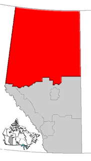
Division No. 17 is a census division in Alberta, Canada. It spans the central and northwest portions of northern Alberta and its largest urban community is the Town of Slave Lake. Division No. 17 is the largest census division in Alberta according to area and also has the lowest population density.

Petroleum industry in Canada

Petroleum production in Canada is a major industry which is important to the economy of North America. Canada has the third largest oil reserves in the world and is the world's seventh largest oil producer and fifth largest oil exporter. In 2015 it produced an average of 621,610 cubic metres per day (3.9 Mbbl/d) of crude oil and equivalent. Of that amount, 61% was upgraded and non-upgraded bitumen from oil sands, and the remainder light crude oil, heavy crude oil and natural-gas condensate. Most of Canadian petroleum production is exported, approximately 482,525 cubic metres per day (3 Mbbl/d) in 2015, with almost all of the exports going to the United States. Canada is by far the largest single source of oil imports to the United States, providing 43% of US crude oil imports in 2015.

Cadotte Lake lake in Alberta, Canada

Cadotte Lake is an unincorporated community in northern Alberta, Canada within Northern Sunrise County. It is located on the northern shore of the homonymous lake, along Highway 986, 79 km (49 mi) east of Peace River and 68 km (42 mi) west of the Bicentennial Highway.

Gleniffer Lake also known as Gleniffer Reservoir is an artificial lake in central Alberta, Canada created in 1983 by the construction of the Dickson Dam which impounded the Red Deer River, a major tributary of the South Saskatchewan River which flows into the Saskatchewan River Basin.

The Enbridge Northern Gateway Pipelines was a project to build a twin pipeline from Bruderheim, Alberta to Kitimat, British Columbia. The eastbound pipeline would have imported natural gas condensate and the westbound pipeline would have exported diluted bitumen from the Athabasca oil sands to a marine terminal in Kitimat for transportation to Asian markets via oil tankers. The project would have also included terminal facilities with "integrated marine infrastructure at tidewater to accommodate loading and unloading of oil and condensate tankers, and marine transportation of oil and condensate." The $CDN 7.9 billion project was proposed in mid-2000s and has been postponed several times. The proposed project would have been developed by Enbridge Inc., a Canadian crude oil and liquids pipeline and storage company.

Long Lake (oil sands) oil sands extraction project

The Long Lake oil sands upgrader project is an in situ oil extraction project 40 km (25 mi) southeast of Fort McMurray in the Athabasca oil sands region of Alberta. The upgrader side of the facility has been shut down indefinitely after the deaths of two workers caused by an explosion January 16, 2016 in the Hydrocracker Unit however the SAGD site is still operational. The project is operated by Nexen, a wholly owned subsidiary of China National Offshore Oil Corporation (CNOOC) Limited. Long Lake is an integrated steam-assisted gravity drainage (SAGD) and upgrading operation that uses a proprietary OrCrude technology as well as hydrocracking and gasification to produce Premium Synthetic Crude (PSC) oil. Production capacity at Long Lake is 72,000 barrels per day (11,400 m3/d) of bitumen which, when upgraded, generates approximately 58,500 barrels per day (9,300 m3/d) of crude oil.

The Beaver Lake Cree Nation is a First Nations band government located 105 kilometres (65 mi) northeast of Edmonton, Alberta, representing people of the Cree ethno-linguistic group in the area around Lac La Biche, Alberta, where the band office is currently located. Their treaty area is Treaty 6. The Intergovernmental Affairs office consults with persons on the Government treaty contacts list. There are two parcels of land reserved for the band by the Canadian Crown, Beaver Lake Indian Reserve No. 131 and Blue Quills First Nation Indian Reserve. The latter reserve is shared by six bands; Beaver Lake Cree Nations, Cold Lake First Nations, Frog Lake First Nation, Heart Lake First Nation, Kehewin Cree Nation, Saddle Lake Cree Nation.

The North Peace Tribal Council represents five First Nations in northwestern Alberta, Canada. The North Peace Tribal Council was incorporated in 1987, by the Beaver First Nation, Dene Tha' First Nation, Little Red River Cree First Nation, and Tallcree Tribal Government. The Lubicon Lake Nation was accepted into membership in 1995, but left in 2013.

Tar Sands Healing Walk organization

The Tar Sands Healing Walk began in 2010. It was founded by Jesse Cardinal, in collaboration with the indigenous women of Keepers of the Athabasca. Eriel Tchekwie Deranger, a Dene women, is the main organizer. One of Eriel’s co-organizers for the Healing Walk is Melina Laboucan-Massimo, a Lubicon Cree environmental activist. Over four consecutive years the Tar Sands Healing Walk brings together hundreds of people to walk in a spiritual gathering to protect culture, environment and climate from the expansion of the tar sands. This women's initiative aims to unite the peoples of the Athabasca River and Lake Watershed to secure and protect water and watershed lands for ecological, social, cultural and community health and well being.

Melina Laboucan-Massimo is a Greenpeace Activist who advocates for indigenous rights and ecological well-being in Canada. Massimo is most known for her installation of a solar panel system in Little Buffalo called The Solar Project.

References

  1. 1 2 "County Statistics". Northern Sunrise County. Retrieved 2011-03-30.
  2. Alberta Municipal Affairs (2010-04-01). "Specialized and Rural Municipalities and Their Communities" (PDF). Archived from the original (PDF) on 2012-02-29. Retrieved 2010-07-03.
  3. Morin, Ivan (December 1988). "Lubicon Land Claim Talks Back On Track". Saskatchewan Indian. p. 6.
  4. "The Grimshaw Accord". Lubicon. Retrieved 15 June 2013.
  5. "Lubicon First Nation sues province and feds over energy revenues". CBC. 10 June 2013. Retrieved 15 June 2013.
  6. Welsch, E. (May 5, 2011). "Size of Oil Spill in Canada Grows." Wall Street Journal.
  7. Vanderklippe, N. (May 4, 2011). "Costs for oil companies pile up after spill." The Globe and Mail.
  8. The Globe and Mail (May 04, 2011). Location of oil spill near Little Buffalo, Alta.
  9. CBC News (February 26, 2013). Plains Midstream reprimanded for 2011 Alberta oil spill. Retrieved on: 2013-02-27.
  10. 1 2 Canadian Press (24 June 2013). "Pennwest pipeline spill estimate grows with salt water". Calgary Herald.
  11. 1 2 3 4 5 "Pennwest pipeline spill in northern Alberta". Metro News. 23 June 2013. Retrieved 25 June 2013.