Craigmyle, Alberta

Last updated

Craigmyle
Canada Alberta relief location map - transverse mercator proj.svg
Red pog.svg
Craigmyle
Location of Craigmyle
Canada relief map 2.svg
Red pog.svg
Craigmyle
Craigmyle (Canada)
Coordinates: 51°40′11″N112°14′35″W / 51.66972°N 112.24306°W / 51.66972; -112.24306
CountryCanada
Province Alberta
Region Southern Alberta
Census division 5
Municipal district Starland County
Government
  Type Unincorporated
  Governing bodyStarland County Council
Population
 (2013) [1]
  Total79
Time zone UTC−07:00 (MST)
  Summer (DST) UTC−06:00 (MDT)
Area code(s) 403, 587, 825

Craigmyle is a hamlet in Alberta, Canada within Starland County. [2] It is located between the towns of Delia and Hanna. It was named in 1912 by a Canadian Northern Railway ahead of the train's arrival in April 1914. [3] The name is said to be based on a Scottish estate. [4] Previously incorporated as a village, Craigmyle dissolved to become a hamlet on 1 January 1972. [5]

Contents

Climate

Climate data for Craigmyle, Alberta
MonthJanFebMarAprMayJunJulAugSepOctNovDecYear
Record high °C (°F)14.0
(57.2)
15.5
(59.9)
26.0
(78.8)
30.0
(86.0)
34.5
(94.1)
37.5
(99.5)
38.5
(101.3)
37.0
(98.6)
35.6
(96.1)
28.9
(84.0)
21.7
(71.1)
15.6
(60.1)
38.5
(101.3)
Mean daily maximum °C (°F)−6.0
(21.2)
−3.2
(26.2)
2.7
(36.9)
11.8
(53.2)
17.7
(63.9)
21.4
(70.5)
24.7
(76.5)
23.6
(74.5)
18.3
(64.9)
11.4
(52.5)
0.6
(33.1)
−3.6
(25.5)
10.0
(50.0)
Daily mean °C (°F)−11.3
(11.7)
−8.7
(16.3)
−2.9
(26.8)
4.9
(40.8)
10.5
(50.9)
14.6
(58.3)
17.3
(63.1)
16.2
(61.2)
11.1
(52.0)
4.6
(40.3)
−4.5
(23.9)
−8.6
(16.5)
3.6
(38.5)
Mean daily minimum °C (°F)−16.6
(2.1)
−14.3
(6.3)
−8.5
(16.7)
−2.1
(28.2)
3.2
(37.8)
7.8
(46.0)
9.9
(49.8)
8.7
(47.7)
3.8
(38.8)
−2.1
(28.2)
−9.6
(14.7)
−14.1
(6.6)
−2.8
(27.0)
Record low °C (°F)−43.3
(−45.9)
−42
(−44)
−38.9
(−38.0)
−26.7
(−16.1)
−11
(12)
−6.1
(21.0)
0.0
(32.0)
−3.5
(25.7)
−10
(14)
−26
(−15)
−34.5
(−30.1)
−45
(−49)
−45
(−49)
Average precipitation mm (inches)14.4
(0.57)
12.6
(0.50)
23.0
(0.91)
25.5
(1.00)
46.7
(1.84)
81.2
(3.20)
63.4
(2.50)
57.8
(2.28)
41.0
(1.61)
15.2
(0.60)
16.5
(0.65)
13.8
(0.54)
411.2
(16.19)
Average rainfall mm (inches)0.0
(0.0)
0.1
(0.00)
1.3
(0.05)
15.4
(0.61)
42.3
(1.67)
81.2
(3.20)
63.4
(2.50)
57.8
(2.28)
38.8
(1.53)
8.1
(0.32)
0.7
(0.03)
0.1
(0.00)
309.3
(12.18)
Average snowfall cm (inches)14.4
(5.7)
12.5
(4.9)
21.7
(8.5)
10.1
(4.0)
4.5
(1.8)
0.0
(0.0)
0.0
(0.0)
0.0
(0.0)
2.3
(0.9)
7.1
(2.8)
15.8
(6.2)
13.7
(5.4)
101.9
(40.1)
Source: Environment Canada [6]

Demographics

Population history
of Craigmyle
YearPop.±%
1901    
1906    
1911    
1916    
1921231    
1926232+0.4%
1931236+1.7%
1936214−9.3%
1941186−13.1%
1946140−24.7%
1951136−2.9%
1956138+1.5%
1961107−22.5%
1966    
1971    
1976    
1981    
1986    
1991    
Source: Statistics Canada [7] [8]

The population of Craigmyle according to the 2013 municipal census conducted by Starland County is 79. [1]

See also

Related Research Articles

<span class="mw-page-title-main">Drumheller</span> Town in Alberta, Canada

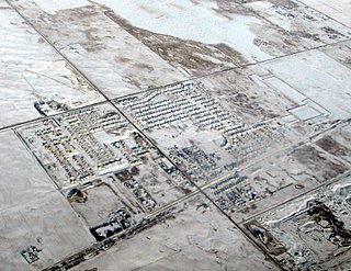
Drumheller is a town on the Red Deer River in the badlands of east-central Alberta, Canada. It is located 110 kilometres (68 mi) northeast of Calgary and 97 kilometres (60 mi) south of Stettler. The Drumheller portion of the Red Deer River valley, often referred to as Dinosaur Valley, has an approximate width of 2 kilometres (1.2 mi) and an approximate length of 28 kilometres (17 mi).

Frank is an urban community in the Rocky Mountains within the Municipality of Crowsnest Pass in southwest Alberta, Canada. It was formerly incorporated as a village prior to 1979 when it amalgamated with four other municipalities to form Crowsnest Pass.

<span class="mw-page-title-main">Stony Plain, Alberta</span> Town in Alberta, Canada

Stony Plain is a town in the Edmonton Metropolitan Region of Alberta, Canada that is surrounded by Parkland County. It is west of Edmonton adjacent to the City of Spruce Grove and sits on Treaty 6 land.

<span class="mw-page-title-main">Strathmore, Alberta</span> Town in Alberta, Canada

Strathmore is a town located in southern Alberta, Canada that is surrounded by Wheatland County. It is along the Trans-Canada Highway approximately 50 kilometres (30 mi) east of Calgary.

<span class="mw-page-title-main">Hythe, Alberta</span> Hamlet in Alberta, Canada

Hythe is a hamlet in northwest Alberta, Canada within the County of Grande Prairie No. 1. It is located on Highway 43 approximately 58 km (36 mi) northwest of the City of Grande Prairie and 73 km (45 mi) southeast of the City of Dawson Creek, British Columbia. It held village status prior to July 2021.

<span class="mw-page-title-main">Kinuso</span> Hamlet in Alberta, Canada

Kinuso is a hamlet in northern Alberta, Canada within Big Lakes County, and surrounded by the Swan River First Nation reserve. It is located approximately 48 kilometres (30 mi) west of Slave Lake and 71 km east of High Prairie along Highway 2, south of the southern shore of Lesser Slave Lake.

<span class="mw-page-title-main">Coleman, Alberta</span> Unincorporated community in Alberta, Canada

Coleman is a community in the Rocky Mountains within the Municipality of Crowsnest Pass in southwest Alberta, Canada. It was formerly incorporated as a town prior to 1979 when it amalgamated with four other municipalities to form Crowsnest Pass.

<span class="mw-page-title-main">Langdon, Alberta</span> Hamlet in Alberta, Canada

Langdon is a hamlet in southern Alberta, Canada under the jurisdiction of Rocky View County. It previously held village status between August 31, 1907, and January 1, 1946.

Clairmont is a hamlet in northern Alberta, Canada within the County of Grande Prairie No. 1. Previously an incorporated municipality, Clairmont dissolved from village status on January 1, 1946 to become part of the Municipal District of Bear Lake No. 740.

Enchant is a hamlet in southern Alberta, Canada within the Municipal District of Taber. It is on Highway 526 and the Canadian Pacific Kansas City railway, between Vauxhall and Lomond. It has an elevation of 810 metres (2,660 ft).

Compeer is a hamlet in east-central Alberta, Canada within Special Area No. 4. Previously an incorporated municipality, Compeer dissolved from village status on December 31, 1936, to become part of the Municipal District of Neutral Hills No. 331.

<span class="mw-page-title-main">Bellis, Alberta</span> Hamlet in Alberta, Canada

Bellis is a hamlet in central Alberta, Canada within Smoky Lake County. Previously an incorporated municipality, Bellis dissolved from village status on January 1, 1946 to become part of the Municipal District of Vilna No. 575.

Cadogan is a hamlet in central Alberta, Canada within the Municipal District of Provost No. 52. Previously an incorporated municipality, Cadogan dissolved from village status on January 1, 1946 to become part of the Municipal District of Hillcrest No. 362.

Cardiff is a hamlet in central Alberta, Canada within Sturgeon County. It is located 3 kilometres (1.9 mi) east of Highway 2, approximately 15 kilometres (9.3 mi) north of Edmonton's city limits. The Town of Morinville is 1.6 kilometres (0.99 mi) to the west of Cardiff.

Chinook is a hamlet in southern Alberta, Canada within Special Area No. 3. It is located on Highway 9 approximately 119 kilometres (74 mi) northeast of Brooks.

Jenner is a hamlet in southern Alberta, Canada within Special Area No. 2. It is located approximately 43 kilometres (27 mi) northeast of Highway 1 and 54 kilometres (34 mi) northeast of Brooks. Previously an incorporated community, Jenner dissolved from village status on June 25, 1943.

Lodgepole is a hamlet in central Alberta, Canada within Brazeau County. It is located approximately 31 kilometres (19 mi) west of Highway 22 and 131 kilometres (81 mi) southwest of Edmonton.

<span class="mw-page-title-main">Monitor, Alberta</span> Hamlet in Alberta, Canada

Monitor is a hamlet in east-central Alberta, Canada within Special Area No. 4. Monitor is located on Highway 41, approximately 215 kilometres (134 mi) north of Medicine Hat.

Queenstown is a hamlet in southern Alberta, Canada within Vulcan County. It is located approximately 26 kilometres (16 mi) south of Highway 1 and 92 kilometres (57 mi) southeast of Calgary.

Ranfurly is a hamlet in central Alberta, Canada within the County of Minburn No. 27. Previously an incorporated municipality, Ranfurly dissolved from village status on January 1, 1946 to become part of the Municipal District of Birch Lake No. 484.

References

  1. 1 2 "Past Census Trackers: 2013 Municipal Censuses". Alberta Population. Archived from the original on November 17, 2021. Retrieved September 25, 2021.
  2. "Specialized and Rural Municipalities and Their Communities" (PDF). Alberta Municipal Affairs. January 12, 2022. Retrieved January 21, 2022.
  3. Battle, Lester (1970). Delia - Craigmyle Saga. Delia: Delia and District Historical Society. p. 610. Archived from the original on September 24, 2015. Retrieved June 21, 2013.
  4. Place-names of Alberta. Ottawa: Geographic Board of Canada. 1928. p. 39. Retrieved April 23, 2019.
  5. "The Alberta Gazette, 1971 (Volume 67) Order in Council 1876/71: Village of Craigmyle Dissolved". Government of Alberta. November 3, 1971. p. 2896. Retrieved October 11, 2015.[ permanent dead link ]
  6. "Craigmyle, Alberta". Canadian Climate Normals 1981–2010 (in English and French). Environment Canada. October 31, 2011. Retrieved March 12, 2014.
  7. "Table 5: Population of urban centres, 1916-1946, with guide to locations". 1946 Census of Alberta (PDF). Vol. Population. Ottawa: Dominion Bureau of Statistics. August 22, 1949. Retrieved August 11, 2022.
  8. "Table 6: Population by census subdivisions, 1901–1961". 1961 Census of Canada (PDF). Series 1.1: Historical, 1901–1961. Vol. I: Population. Ottawa: Dominion Bureau of Statistics. March 8, 1963. Retrieved August 11, 2022.