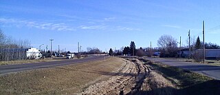
Ardrossan is a hamlet in Alberta, Canada, within Strathcona County. It is located on Highway 824, approximately 7 kilometres (4.3 mi) east of Sherwood Park.

South Cooking Lake is a hamlet in Alberta, Canada within Strathcona County. It is located on Highway 14, approximately 19 km (12 mi) southeast of Sherwood Park.
Cochrane Lake is a hamlet in southern Alberta under the jurisdiction of Rocky View County. Statistics Canada also recognizes a smaller portion of the hamlet as a designated place under the name of Cochrane Lake Subdivision.

Atmore is a hamlet in Alberta, Canada within Athabasca County. It is located 1 km (0.62 mi) east of the junction of Highway 55 and Highway 63, 43 km (27 mi) west of Lac La Biche, 54 km (34 mi) east of Athabasca and 250 km (160 mi) south of Fort McMurray.
Brule is a hamlet in west-central Alberta, Canada within Yellowhead County. It is located on the northwest shore of Brûlé Lake, approximately 20 kilometres (12 mi) west of Hinton. It has an elevation of 1,040 metres (3,410 ft).
Mountain View is a hamlet in Alberta, Canada within Cardston County. It is located along Highway 5 approximately 25 kilometres (16 mi) west of Cardston and 20 kilometres (12 mi) east of Waterton Lakes National Park near the United States border. It is also a kickoff point for visitors to Police Outpost Provincial Park, 18 kilometers to the south.
Sandy Lake, also known as Pelican Mountain, is a hamlet in Alberta, Canada within the Municipal District of Opportunity No. 17. It is located on Highway 813, between Calling Lake and Wabasca. It has an elevation of 565 metres (1,854 ft).

Grassy Lake is a hamlet in Alberta, Canada within the Municipal District of Taber. It is located on the Crowsnest Highway (Highway 3), midway between the cities of Lethbridge to the west and Medicine Hat to the east. It is approximately 13 km (8.1 mi) west of Burdett and 34 km (21 mi) east of Taber. It has an elevation of 810 metres (2,660 ft). It was formerly incorporated as a village, dissolving into the Municipal District of Taber on July 1, 1996.
North Cooking Lake is a hamlet in Alberta, Canada within Strathcona County. It is located on Highway 630 and on the northeast shore of Cooking Lake, approximately 24 kilometres (15 mi) southeast of Sherwood Park. It is 4 kilometres (2.5 mi) south of the Waskehegan Staging Area entrance to Cooking Lake-Blackfoot Grazing, Wildlife Provincial Recreation Area.
Josephburg is a hamlet in Alberta, Canada within Strathcona County. It is located on Highway 830, 6.5 kilometres (4.0 mi) east of Fort Saskatchewan. It is near Alberta's Industrial Heartland, home to petrochemical industries.

Antler Lake is a hamlet in Alberta, Canada within Strathcona County. It is located on the shores of Antler Lake on Range Road 211 and 211A just north of Wye Road, approximately 18 km (11 mi) east of Sherwood Park and 25 km (16 mi) northwest of Tofield.
Collingwood Cove is a hamlet in Alberta, Canada within Strathcona County. It is located at the terminus of Highway 629, approximately 17 kilometres (11 mi) southeast of Sherwood Park.

Hastings Lake is a hamlet in Alberta, Canada within Strathcona County. It is located on the south shore of Hastings Lake, approximately 40 kilometres (25 mi) southeast of Sherwood Park. It is 1.5 kilometres (0.93 mi) north of Highway 14.
Beaver Lake is a hamlet in northern Alberta, Canada within Lac La Biche County. It is located on the shore of Beaver Lake, 4 kilometres (2.5 mi) east of Highway 36, approximately 116 kilometres (72 mi) northwest of Cold Lake.

Bellis is a hamlet in central Alberta, Canada within Smoky Lake County. Previously an incorporated municipality, Bellis dissolved from village status on January 1, 1946 to become part of the Municipal District of Vilna No. 575.
Benalto is a hamlet in central Alberta, Canada within Red Deer County. It is located approximately 13 kilometres (8.1 mi) west of the Town of Sylvan Lake. Benalto is also recognized by Statistics Canada as a designated place.
Buck Lake is a hamlet in central Alberta, Canada within the County of Wetaskiwin No. 10. It is located on Highway 13, approximately 109 kilometres (68 mi) southwest of Edmonton. It is located on the shore of Buck Lake.
Joussard is a hamlet in northern Alberta within Big Lakes County. It is 2 kilometres (1.2 mi) north of Highway 2, approximately 83 kilometres (52 mi) west of Slave Lake.
Long Lake is a hamlet in central Alberta, Canada within Thorhild County. It is located on the west shore of Long Lake, approximately 12 kilometres (7.5 mi) east of Highway 63 and 114 kilometres (71 mi) northeast of Edmonton.
Moon River Estates is a hamlet in southern Alberta, Canada within the Municipal District of Willow Creek No. 26 that was declared on October 17, 1984. It is located 6 kilometres (3.7 mi) south of Highway 3, approximately 22 kilometres (14 mi) west of Lethbridge.


